Cayman: Tropical Laura Bulletin – 10AM UPDATE From 4am
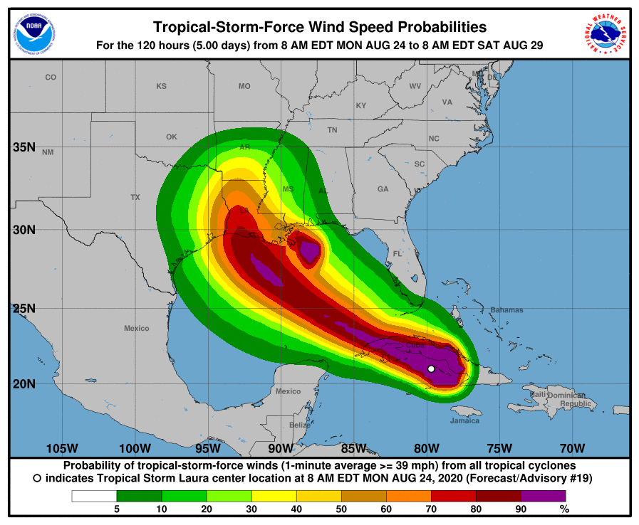
UPDATE: At 10 am Tropical Storm Laura was located near Latitude 21.2 North… Longitude 80.6 West or about 115 mile north-northwest of Cayman Brac and 142 miles north-northeast of Grand Cayman. The storm is moving towards the west-northwest near 20 mph with maximum sustained winds of 60 mph.
THE GOVERNMENT OF THE CAYMAN ISLANDS MAINTAINS A TROPICAL STORM WARNING IN PLACE FOR THE SISTER ISLANDS.
Conditions expected over the Sister Islands:
The latest forecast issued by the National Hurricane Center in Miami, Florida, suggests that Tropical Storm Laura will continue on its present track. This projection has the Sister Islands has Tropical Storm force winds ceasing by this afternoon. Wind direction is expected to be from the south-southwest near 25 to 30 knots becoming southeasterly 15 to 20 knots by this evening. Higher gusts nearing 35 knots are likely especially through this afternoon.
Moderate to locally heavy showers are expected through this evening as Tropical Storm Laura moves along the south coast of Cuba. Rainfall accumulation estimates between 2 to 4 inches with a localized maximum of 6 inches of rainfall could occur over the Sister Islands during the next 24 hours and FLOODING OF LOW LYING AREAS ARE LIKELY. Residents in these low-lying areas should take the necessary precautions.
Seas conditions over the Sister Islands are expected to be rough with wave heights of 6 to 8 feet today and subsiding with wave heights of 4 to 6 feet by tonight. ALL MARINE INTEREST OVER THE SISTER ISLANDS SHOULD SEEK SAFE HARBOUR AND REMAIN THERE UNTIL AT LEAST TOMORROW MORNING.
————————————————————————————————————————————————————————————————————————————————————————————-
4 am August 24th 2020, Tropical Laura Bulletin 3.
At 4 am Tropical Storm Laura was located near Latitude 20.8 North… Longitude 78.9 West or about 95 mile northeast of Cayman Brac and 192 miles -northeast of Grand Cayman. The storm is moving towards the west-northwest near 21 mph with maximum sustained winds of 65mph. On this track Tropical Storm Laura is expected to at its closest point of approach be near 91miles north-northeast of Cayman Brac by around 5am today.
THE GOVERNMEMT OF THE CAYMAN ISLANDS MAINTAINS A TROPICAL STORM WARNING IN PLACE FOR THE SISTER ISLANDS.
Conditions expected over the Sister Islands:
The latest forecast issued by the National Hurricane Center in Miami, Florida, suggests that Tropical Storm Laura will continue on its present track. This projection has the Sister Islands experiencing Tropical Storm force winds through this afternoon. Wind direction is expected to be from the south-southwest near 25 to 30 knots, south-southeasterly by mid-morning and becoming southeasterly 15 to 20 knots by this evening. Higher gusts nearing 35knost are likely especially through this afternoon.
Moderate to locally heavy showers are expected through this evening as Tropical Storm Laura moves along the south coast of Cuba. Rainfall accumulation estimates between 2 to 4 inches with a localized maximum of 6 inches of rainfall could occur over the Sister Islands during the next 24 hours and FLOODING OF LOW LYING AREAS ARE LIKELY. Residents in these low-lying areas should take the necessary precautions.
Seas conditions over the Sister Islands are expected to be rough with wave heights of 6 to 8 feet tomorrow morning and subsiding with wave heights of 4 to 6 feet by tonight. ALL MARINE INTEREST OVER THE SISTER ISLANDS SHOULD SEEK SAFE HARBOUR AND REMAIN THERE UNTIL AT LEAST TOMORROW EVENING.