Tropical Storm Laura shatters record, sets course toward US
From AccuWeather News
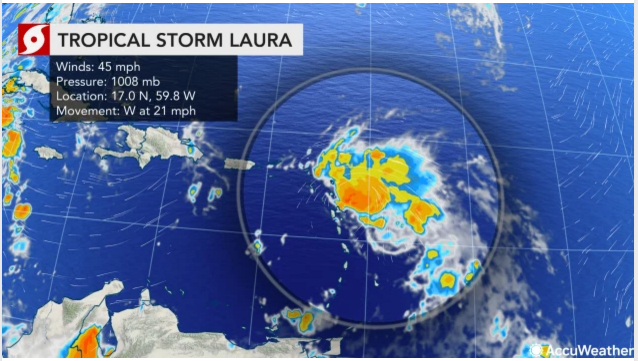
Laura is the ninth storm to set a new early benchmark this season, beating the previous “L-storm” record held by Luis, which formed on Aug. 29, 1995. Tropical storm watches are in effect for the Leeward Islands, Puerto Rico and the Virgin Islands, as well as the southeastern Bahamas as Laura races westward at 21 mph.
AccuWeather Global Weather Center – August 21, 2020 – Tropical Storm Laura developed in the Atlantic just a couple of hundred miles east-southeast of the northern Leeward Islands on Friday morning. The storm not only shattered the record for the earliest L-named storm on record in the basin, but it will also forge a track toward the United States early next week.
Data found from a National Oceanic and Atmospheric Administration (NOAA) Hurricane Hunter aircraft flight signaled that Tropical Depression 13 had strengthened to Laura and had maximum sustained winds of 45 mph. Tropical Depression 13 had formed in the central Atlantic late Wednesday evening.
Laura is the ninth storm to set a new early benchmark this season, beating the previous “L-storm” record held by Luis, which formed on Aug. 29, 1995. Tropical storm watches are in effect for the Leeward Islands, Puerto Rico and the Virgin Islands, as well as the southeastern Bahamas as Laura races westward at 21 mph.

Accuweather meteorologists have been watching the tropical Atlantic with extra close attention as the anticipated ramp-up of an already record-setting hurricane season begins. Forecasters are monitoring Tropical Depression 14, which could soon become Tropical Storm Marco, and they warn that both systems could make U.S. landfalls a day apart early next week.
Another disturbance near the coast of Africa, which is expected to take a few more days to develop, is also being watched closely by AccuWeather meteorologists.
The Leeward Islands are first in the path for impacts from Tropical Storm Laura.

About AccuWeather, Inc. and AccuWeather.com
Laura will spread gusty winds and the possibility of periodic heavy rainfall westward over parts of the Leeward Islands from Friday to Saturday,” Lead Tropical Forecaster and Senior Meteorologist Dan Kottlowski said.
With the current forecast for some gusty winds and downpours to the northern Caribbean, Laura will be less than one on the AccuWeather RealImpact Scale™ for Hurricanes, a scale that rates tropical systems from less than one to 5 based on expected impacts.

People across the northern islands of the Caribbean, as well as the Turks and Caicos, southern Bahamas, the Florida Keys and the southern part of the Florida Peninsula should be prepared for tropical storm conditions, as an average, as the storm moves along with the potential for more significant conditions, depending on the exact track and strength of the feature itself.

Should the system track just north of the northern islands of the Caribbean, conditions there may not be severe, but it could allow the center of the storm to strengthen further over warm water with minimal impediment from the high mountains in Puerto Rico and Hispaniola. Such a scenario could bring damaging conditions to the Turks and Caicos and part of the southern islands of the Bahamas.
AccuWeather, recognized and documented as the most accurate source of weather forecasts and warnings in the world, has saved tens of thousands of lives, prevented hundreds of thousands of injuries and tens of billions of dollars in property damage. With global headquarters in State College, PA and other offices around the world, AccuWeather serves more than 1.5 billion people daily to help them plan their lives and get more out of their day through digital media properties, such as AccuWeather.com and mobile, as well as radio, television, newspapers, and the national 24/7 AccuWeather Network channel. Additionally, AccuWeather produces and distributes news, weather content, and video for more than 180,000 third-party websites.
“We expect Laura to move across the Florida Straits and it may strengthen into a hurricane on Sunday or Monday before taking a turn northward in the Gulf of Mexico,” Kottlowski said.
This forecast is based on the anticipated strengthening and westward extension of the Bermuda-Azores high pressure area. Should the high fail to strengthen and extend westward, there would be room for an earlier northward turn.

There are also other players on the long-range weather maps with both a southward dip in the jet stream over the South Central states and the Gulf of Mexico and Tropical Depression 14, which is expected to strengthen into Tropical Storm Marco and track into the western Gulf of Mexico early next week as well.
This southern U.S. feature is forecast to weaken this weekend to next week. How quickly the weakening occurs may determine whether this jet stream dip tugs the tropical system northward or allows it to continue on a west-northwest path through the Gulf.
A similar effect could be seen on Tropical Depression 14, either being tugged farther north and east, or turning more westerly in the Gulf. The circulations of both tropical systems, which are expected to be tropical storms or hurricanes by that time, could also interact with each other, changing their respective tracks and strength.
A third disturbance just emerged from Africa and is forecast to move westward across the Atlantic in the coming days.

Prior to Laura’s formation, Cristobal, Edouard, Fay, Gonzalo, Hanna, Isaias, Josephine and Kyle had all set new records for their designated letters in 2020. With the 2020 Atlantic hurricane season already way ahead of the average pace and surpassing marks left by the notorious 2005 hurricane season, and the height of the hurricane season looming from the end of August to early October, not only are more records likely to be set, but there is also the likelihood that lives and property will be threatened in the weeks ahead.
The lid could soon come off the Atlantic basin with the potential for multiple named systems spinning at the same time, including multiple threats to lives and property at the same time from the Caribbean to North America.

AccuWeather meteorologists are expecting a hyperactive year for tropical storms and hurricanes — enough that Greek letters may once again be needed. Due to 2020’s record pace and upcoming conditions expected in the basin,AccuWeather meteorologists upped their forecast for the number of tropical storms in late July, with up to 24 now predicted and up to 11 hurricanes projected for the season.
Tropical storms are named for most letters of the alphabet, with the exception of Q, U, X, Y and Z. Beyond that, Greek letters are used to name systems. The infamous 2005 Atlantic hurricane season holds the record for the greatest number of named storms at 28, and 2005 was the only year to use Greek letters.
For more on this story, video and audio go to: AccuWeather