Tropical Storm Gonzalo Forecast to become a Hurricane before reaching the Windward Islands this weekend

From Weather.com
At a Glance
- Tropical Storm Gonzalo is tracking toward the Lesser Antilles in the Atlantic.
- It is forecast to become a hurricane Thursday.
- But its intensity forecast is very uncertain.
- It should arrive in the southern Windward Islands Saturday, as a hurricane or tropical storm.
- Gonzalo is the earliest seventh named storm to form in the Atlantic.
Tropical Storm Gonzalo is expected to become the first hurricane of the 2020 Atlantic hurricane season, prompting hurricane watches in the Windward Islands, but its forecast remains a significant challenge with large uncertainty.
Gonzalo is located several hundred miles east of the southern Windward Islands, moving west.
A hurricane watch has been issued for Barbados and St. Vincent and the Grenadines, where hurricane conditions are possible Saturday.
(MORE: Hurricane Season Terms You Need to Know)
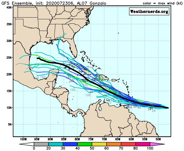
Gonzalo’s tiny size and the environment around it pose a major forecast challenge for its future intensity. You might have to squint to pick up the size of its tropical storm-force winds shaded orange in the graphic below.

Dry air is currently plentiful near Gonzalo, and appears to be having an influence on it, disrupting the organization of convection near its center. You can see this vast stretch of dry air in the satellite image below, denoted by the orange and red areas.
While shearing winds are currently not near Gonzalo, it may encounter some modest wind shear near the Windward Islands or eastern Caribbean Sea later this weekend.

These factors would argue for a weakening of Gonzalo.
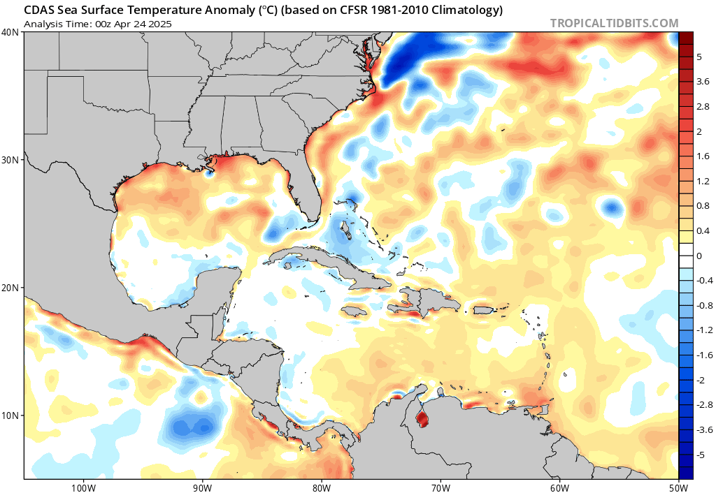
However, there is an ample supply of warm, deep ocean waterahead of Gonzalo, generally warmer than average for this time of year.
Furthermore, Gonzalo is a tiny tropical storm. Small tropical storms like this can intensify quickly in the right conditions, but they can also succumb to unfavorable conditions more quickly than a larger storm. In other words, they can strengthen and weaken much more and at a faster rate than expected.
So, the range of outcomes for the intensity forecast is large, anywhere from this storm weakening or dissipating near the Windward Islands, to a hurricane striking the Windward Islands and continuing into the eastern Caribbean Sea.
Fortunately, the track forecast is a bit more straightforward. We expect a general west-northwest track into the Windward Islands by Saturday, then into the eastern Caribbean Sea by Sunday.
Gonzalo’s small size also means its areal extent of impacts may be small, so any subtle shift in the track could mean significant changes in impact in the Windward Islands.
Given the intensity conundrum, it’s uncertain how far Gonzalo will travel into the Caribbean next week.

The southern Windward Islands should be prepared for strong winds, heavy rainfall and rough surf from Gonzalo this weekend. It’s too early to determine the severity of any impacts given the uncertain intensity forecast explained earlier.
Gonzalo is the earliest seventh named tropical storm on record to form in the Atlantic basin, according to Phil Klotzbach, a tropical scientist at Colorado State University. The previous record was held by Tropical Storm Gert, which developed on July 24, 2005.
The Weather Company’s primary journalistic mission is to report on breaking weather news, the environment and the importance of science to our lives. This story does not necessarily represent the position of our parent company, IBM.
For more on this story go to: WEATHER.COM


