Eastern Pacific may yield Gulf of Mexico tropical concerns/Cayman premier hurricane message
 The Premier’s Hurricane Season Message 2014
GRAND CAYMAN, Cayman Islands – As we stop for a moment and realise how fast this year’s calendar has inched toward 1 June and the beginning of another hurricane season, I and many others are reminded that this will be the 10th year since Grand Cayman took the full brunt of Hurricane Ivan.
This year will also be the sixth anniversary since Hurricane Paloma devastated Cayman Brac and parts of Little Cayman.
It is my fear that we are becoming complacent in our preparations. I pray to God that everyone who experienced those two storms remembers, as this new hurricane season approaches, how important it is to not only stock up on your hurricane supplies, but to have a plan for evacuations either off Island, to a shelter, to inland property of family or friends or to stay home and ride out any potential storms. If you do decide to stay home, please ensure that your house is a safe place to remain.
While the early predictions are for a quiet 2014 Atlantic Hurricane Season, I would urge everyone to be prepared. Do not be lulled by the suggestion that there will be nine tropical storms but only three becoming hurricanes as is predicted this year.
Annual hurricane predictions are merely a best estimate of expected hurricane activity in the Atlantic, Gulf of Mexico and Caribbean.
The Colorado State forecast was issued on 11 April. The United States’ National Oceanic and Atmospheric Administration headed to New York City on 22 May to make its predictions of a quiet season. I make mention of this because it is the first time NOAA has left either its South Florida or Washington, D.C., domains to issue the yearly prediction. They did this in New York because of the damage wreaked to the Eastern Seaboard by Superstorm Sandy, which slammed that region in October 2012.
A stew pot of ingredients helped a niggling Category I Hurricane Sandy become the massive storm that left behind $100 billion in damages and a United States populace reeling at loss of life and property.
We saw in Hurricane Ivan that storms can be fickle. I remember well watching the track with Ivan and being more concerned about our Sister Islands and our friends in Jamaica. Then it wobbled. I dare say, the majority of us on Grand Cayman were not prepared; after all, it had been 16 years since Hurricane Gilbert and some 70 years since Cayman had felt the massive blows of a killer storm in 1932.
In the past 10 years many will have moved to these Islands who don’t know about hurricane preparations. I ask all Caymanians and those who call these Islands home and know how to prepare to reach out to the newcomers and see that they have proper hurricane supplies and plans.
If you do not yet have a personal hurricane plan, please get one in place. Be certain that you have your hurricane supplies and, if you live in a high risk or vulnerable area, plan your escape route to the nearest hurricane shelter. Government preparedness cannot be a substitute for personal preparedness. We all need to be ready so that we can survive any storms that come our way and be in a better position to do any necessary rebuilding.

There can be information overload, especially as storms approach our shores, but I urge you to pay attention to the Government announcements and bulletins when they become necessary.
The National Weather Service, emergency managers from Hazard Management Cayman Island and the local media will again work together to get necessary information out to the public in a regular and timely manner.
It is my prayer that the early predictions ring true and that God spares these Islands once again during this, the 2014 Hurricane Season
Eastern Pacific may yield Gulf of Mexico tropical concerns
By Kristina Pydynowski, Senior Meteorologist From Accuweather
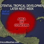
Tropical troubles brewing in the eastern Pacific may lead to concerns in the Gulf and far northwestern Caribbean soon after the official start to the Atlantic hurricane season.
AccuWeather.com meteorologists are monitoring an area south of Mexico, in the eastern Pacific, for a new tropical storm to take shape early next week.
It is possible that the system’s energy could then slowly fuel tropical development in the Atlantic Basin in the days that follow.
Hurricane season in the Atlantic Basin officially commences on June 1.
After tracking across and bringing the threat of flooding rain to southern Mexico and neighboring Central America, energy from the system is likely to reach the southern Gulf of Mexico or the far northwestern Caribbean during the latter part of next week.
“The environment that we are seeing unfolding across the Gulf of Mexico and far northwestern Caribbean for next week would cause any tropical feature to move slowly and support possible slow development,” stated AccuWeather.com Meteorologist Rob Miller.
A slower solution would increase the chances of the system developing, according to AccuWeather.com Hurricane Expert Dan Kottlowski.
“The faster the system reaches the Gulf of Mexico, it will have a harder time developing due to the presence of strong wind shear,” Kottlowski stated. Wind shear refers to winds above the surface that can rip apart developing tropical systems.
“The longer it waits to come out, the better chances the wind shear slackens and development takes place.”
Regardless of whether a tropical system takes shape, heavy rain could be drawn across western Cuba and northward to Florida and the central Gulf Coast later next week or the following weekend.
The area of concern for tropical development in both basins is currently located several hundred miles south of southern Mexico and is a disorganized cluster of showers and thunderstorms.
“A broad area of low pressure with tropical characteristics is expected to organize out of this cluster by Sunday,” stated Miller.
“It will tend to drift northward into the Gulf of Tehuantepec by Tuesday, possibly strengthening into a strong tropical storm or hurricane.”
The waters in the path of the system are sufficiently warm for tropical development. While some wind shear is present, it is not overly strong.
The next tropical storm in the eastern Pacific would acquire the name “Boris.”
Miller expects the system to move inland from the Gulf of Tehuantepec around Tuesday of next week.
“The threat for damaging wind would be in a concentrated area around the point of landfall. Flooding rain and mudslides would be the main impact with some mountainous areas potentially receiving 10 to 20 inches (250 to 500 mm) of rain through early next week,” Miller continued.
As the system moves onshore and its moisture is drawn northward, heavy rain is likely to overspread the majority of far southeastern Mexico, including the Yucatan Peninsula, as well as Guatemala and Belize.
Cities potentially to endure a soaking from the system include Oaxaca, Veracruz, Merida, Belmopan and Guatemala City. Vacationers at the resort cities of Cancun and Chetumal also face an unpleasant wet stretch of weather.
“It has already been active across the resort areas on the Yucatan Peninsula due to daily thunderstorms, but the weather will only get worse next week as moisture from the eastern Pacific system comes into play,” Miller stated.
Despite the disruptions to vacationers and the prospect of flooding and mudslides, Miller pointed out that the rain will bring long-term benefits to easing the ongoing drought across the area.
If the system in the eastern Pacific acquires the name “Boris” and makes the track across southern Mexico without dissipating, it would then keep the name “Boris” in the Gulf of Mexico or northwestern Caribbean.
If the system dissipates over southern Mexico and only a piece of its energy fuels a new tropical storm, the new system would acquire a name from the Atlantic Basin’s list. The first tropical storm of 2014 in the Atlantic would be named “Arthur.”
For more on this story go to:
http://www.accuweather.com/en/weather-news/eastern-pacific-may-yield-gulf/27857594
Related story
Storm could be brewing in Caribbean
By Kevin Robinson, From Peniscola News Journal
Early predictions by Crown Weather Service meteorologists indicate that a low pressure system could form in the Caribbean by early next week and reach the Gulf of Mexico as a tropical storm soon afterward.
It will still be several days before meteorologists will be able to gauge the brewing storm’s strength and path with certainty, but Rob Lightbown, owner of Crown Weather Service, said that the system will definitely drench the Panhandle.
“At the very minimum we’ll see a significant amount of rainfall stream out of the Caribbean into the Panhandle area … possibly 6-10 inches between late next week and the beginning of the following week, which is obviously something you folks don’t need,” he said.
Crown Weather Services of Caribou, Maine complies data from numerous weather prediction models and amalgamates them into one forecast. Lightbown said that several models show the storm developing off the coast of Belize around June 2 or 3.
From there, Lightbown believes a high pressure system over the Atlantic will push the system north-northeast or northeast until it makes landfall June 6 or 7.
“The big wild card is whether this develops into a tropical storm,” Lightbown said.
He said that amount of wind shear around the system will be the chief determining factor in whether it develops into a tropical storm or depression, or just produces heavy rain.
The National Weather Service is predicting a high probability of rain during the next several days. Meteorologist Jack Cullen of the National Weather Service in Mobile said the potential for flooding is high given that the ground still is partly saturated from the severe storms of April 29 and 30.
“We’ve had a good dry week or so, so we’ve had a chance to dry out a bit,” Cullen said. “But the ground is still fairly wet deep down, and it’s not going to take much rain to cause problems.”
A flood watch is in effect for Escambia and Santa Rosa counties until 6 p.m. today.
Last week, the National Oceanic and Atmospheric Association released its annual outlook for the 2014 Atlantic Hurricane Season. Forecasters predict between eight and 13 named storms, of which three to six could become hurricanes including one or two major hurricanes.
National Hurricane Preparedness week is under way and starting Saturday, items such as lamps, flashlights, generators, batteries, fuel containers and more will be tax free until June 8. A full list of qualifying items is available at myflorida.com/dor.
For more information about Crown Weather Services, visit http://www.crownweather.com
(Photo: AFP AFP/Getty Images)
For more on this story go to: http://www.pnj.com/story/news/2014/05/29/crown-weather-service-tropical-storm-pensacola-panhandle/9742037/
Related story:
2014 Atlantic Hurricane Season Birdseye Discussion #1
By: NCHurricane2009 From Wunderground
Even though the Atlantic Hurricane Season officially starts about one hour from now…releasing my first discussion of the season due to enhanced thunderstorm activity currently in the Gulf of Mexico extending southward into the western Caribbean Sea. This activity is currently supported by split flow upper divergence between southerlies on the southeast flank of a cut-off upper vortex over the Texas/Louisiana area and mainstream upper westerlies to the south of the upper vortex. This split flow upper divergence also supports a surface trough across the Gulf of Mexico. The aforementioned upper vortex and surface trough are marked as a blue L and red-dashed line in the atmospheric features chart below.
Their are no signs of further organization in this activity…which is why I am not considering this system a special feature at this time. However over the course of the next week…what is currently tropical disturbance Invest 93-E in the Eastern Pacific is forecast to move northward across southeast Mexico and western Central America…eventually toward the Gulf of Mexico…where it could agitate the weather currently enhanced by the upper vortex further. The GFS computer model suggests tropical cyclone formation in the eastern Gulf from this scenario about 6 days from now…while no additional computer models show development.
…ATMOSPHERIC FEATURES BIRDSEYE CHART… Click to enlarge
This chart is generated based on surface analysis from the National Hurricane Center TAFB at 1800Z, and the 1925Z-released WPC analysis.
Features boxed in green…if any…are mentioned in the National Hurricane Center (NHC) traditional 48-hour outlook and or are considered an “Invest” on the Naval Research Laboratory site of the US Navy at the time the chart was generated. I do not box features in green if they are only included in the NHC’s longer term 5-day outlook.
In light blue is upper air analysis, with 200 mb wind barbs calculated by GOES satellite imagery showing the upper-level wind direction. Based on the 200 mb wind barbs, blue-dashed lines are locations of upper troughs, blue-zig-zag lines are locations of upper ridges. Blue Ls are locations of upper lows, blue Hs are locations of upper ridges.
In red is surface analysis, with solid lines indicating locations of surface fronts, dashed lines indicating locations of surface troughs, and zig-zag lines indicating surface ridge axes. Ls indicate surface lows, Hs indicate surface highs.
 …THERMODYNAMICS BIRDSEYE CHART… (Click to enlarge)
This chart is generated using GOES water vapor satellite imagery. Brown indicates dry air. White, blue, and purple indicates moist air. An increase in moisture indicates slower air parcel lapse rates with elevation and hence an increase toward instability.
Sea-surface temperatures are overlaid with light blue isotherms. The 26 deg C isotherm is highlighted in red. Waters at and south of the 26 deg C isotherm indicate low-level warmth and hence faster environmental lapse rates with elevation (more instability). Waters north of the 26 deg C isotherm indicate slower environmental lapse rates with elevation (less instability).
For more on this story go to: http://www.wunderground.com/blog/NCHurricane2009/comment.html?entrynum=392
Related story:
Global tropical cyclones shifting poleward as the climate warms
Dr. Jeff Masters From Weather Underground
Over the past 30 years, the location where tropical cyclones reach their maximum intensity has been shifting toward the poles in both the northern and southern hemispheres at a rate of about 35 miles (1/2° of latitude) per decade, according to a May 2014 study published in the journal Nature. Tropical cyclones include tropical storms, hurricanes, and typhoons. “Historical intensity estimates can be very inconsistent over time, but the location where a tropical cyclone reaches its maximum intensity is a more reliable value and less likely to be influenced by data discrepancies or uncertainties,” said NOAA/University of Wisconsin lead author Jim Kossin in a NOAA press release. The researchers used data only from 1982 – 2012, the era when accurate global satellite data makes a full study of tropical cyclone intensities most feasible.
Figure 1. MODIS image of Hurricane Earl taken at 2 pm EDT September 1, 2010, by NASA’s Aqua satellite. Earl’s 140 mph Category 4 winds when it was off the coast of Northern Florida on September 2, 2010, made it the third strongest Atlantic hurricane on record so far north in U.S. coastal waters. Only Hurricane Esther of 1961 and Hurricane Connie of 1955 made it farther north in U.S. coastal waters at a higher strength. Both storms had winds 5 mph stronger than Earl–145 mph. One other Atlantic hurricane was stronger than Esther and Connie at a more northerly latitude–the second storm of 1922, which had winds of 150 mph. However, this hurricane was far out at sea, north of Bermuda. Image credit: NASA.
Causes of the poleward shift
The poleward shift in tropical cyclones was likely due to observed changes in vertical wind shear and tropical cyclone potential intensity over the past 30 years, which changed the regions most favorable for tropical cyclone development, the researchers said. Wind shear has been decreasing closer to the poles, and the potential intensity has been increasing (the potential intensity of a tropical cyclone depends upon the sea surface temperature underneath the storm and the amount of atmospheric instability, with warm air near the surface and cold air aloft giving higher instability and potential intensity.) Interestingly, these shifts were primarily observed in the Western North Pacific Ocean and the Southern Hemisphere’s ocean areas. The North Atlantic Ocean and Eastern North Pacific exhibited only small poleward trends; the North Indian Ocean did not show any poleward trends. The researchers proposed that the poleward migration of tropical cyclones is linked to the observed poleward migration of the tropics over the past 30 years, since both have migrated similar distances. The causes of the expansion of the tropics are not certain, but a 2013 study led by Christopher Lucas of the Centre for Australian Weather and Climate Research/Bureau of Meteorology, The expanding tropics: a critical assessment of the observational and modeling studies, found that including increasing greenhouses gases, stratospheric ozone depletion, and pollution in the form of small particles were likely to blame, with no single factor by itself explaining the full expansion.
Consequences
As tropical cyclones move poleward, some regions closer to the Equator may experience reduced risk of damage, while coastal populations and infrastructure poleward of the tropics may experience increased risk. With their devastating winds and flooding, tropical cyclones can especially endanger coastal cities not adequately prepared for them. Additionally, regions in the tropics that depend on cyclones’ rainfall to help replenish water resources may be at risk for lower water availability as the storms migrate away from them.
References
Kossin, J.P, K.A. Emanual, and G.A. Vecchi, 2014, The poleward migration of the location of tropical cyclone maximum intensity, Nature 509, 349–352 (15 May 2014) doi:10.1038/nature13278
Dr. Kossin used a similar data set in a 2013 paper, Trend Analysis with a New Global Record of Tropical Cyclone Intensity, to show that the strongest Atlantic hurricanes that reached a peak strength of at least 112 mph (Category 3) increased in strength by 18 mph (8 m/s) per decade between 1982 – 2009. Globally, the increase in strength of the strongest tropical cyclones was much smaller, about 2 mph (1 m/s) per decade.
Dr. Kossin also published a 2008 paper in Geophysical Research Letters, “Is the North Atlantic hurricane season getting longer?” He concluded that yes, there is a “apparent tendency toward more common early- and late-season storms that correlates with warming Sea Surface Temperature but the uncertainty in these relationships is high”. See my blog post on this paper here.
What the official climate assessments say about climate change and hurricanes
The 2013 IPCC report gives “low confidence”–a 20% chance–that we have observed a human-caused increase in intense hurricanes in some parts of the world. This is a reduction in odds from the 2007 report, which said that it was more likely than not (greater than 50% chance.) The IPCC likely took note of a landmark 2010 review paper, “Tropical Cyclones and Climate Change”, authored by ten top hurricane scientists, which concluded that the U.S. had not seen any long-term increase in landfalling tropical storms and hurricanes, and that “it remains uncertain whether past changes in tropical cyclone activity have exceeded the variability expected from natural causes.” The 2013 IPCC report predicts that there is a greater than 50% chance (more likely than not) that we will see a human-caused increase in intense hurricanes by 2100 in some regions; this is also a reduction from the 2007 report, which said this would be likely (66% chance or higher.)
The May 2014 United States National Climate Assessment found that “The intensity, frequency, and duration of North Atlantic hurricanes, as well as the frequency of the strongest (Category 4 and 5) hurricanes, have all increased since the early 1980s. The relative contributions of human and natural causes to these increases are still uncertain. Hurricane-associated storm intensity and rainfall rates are projected to increase as the climate continues to warm.”
For more on this story go to: http://www.wunderground.com/blog/JeffMasters/comment.html?entrynum=2686