Tropical Storm Watch issued for Grand Cayman and Jamaica -UPDATED 8:00EDT
UPDATE
NOAA HURRICANE HUNTERS INVESTIGATING THE DISTURBANCE
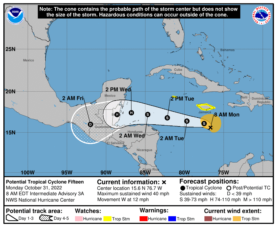
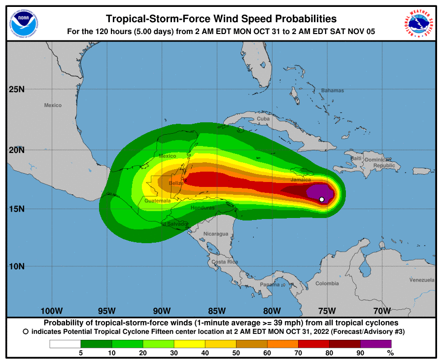
Potential Tropical Cyclone Fifteen Discussion Number   3
NWS National Hurricane Center Miami FL       AL152022
500 AM EDT Mon Oct 31 2022

The system has changed little in organization overnight.  Deep
convection is not very extensive at this time and convective banding
features are rather limited, as evidenced by a Dvorak classification
of T1.0 from TAFB.  Thus, the disturbance still lacks sufficient
organized convection to be classified as a tropical cyclone.
Observations from an Air Force Hurricane Hunter aircraft and
scatterometer data indicate that the circulation is somewhat
elongated from south to north, and the maximum winds are 30-35 kt.
Satellite images show that the broad center is located just to the
west of the main area of deep convection.

The disturbance continues moving generally westward, or around
270/10 kt.  A mid-level anticyclone to the north of the system
should maintain a westward to west-northwestward track for the next
48 hours or so.  Then, as the high shifts westward, the system is
forecast to turn west-southwestward  when it nears the coast of
Belize or eastern Yucatan.  The official track forecast is close to
the model consensus and not much different from the previous NHC
prediction.  It should be noted, however, that the the forecast
track could undergo some additional adjustments until the
circulation center becomes better defined.

It is expected that the system will acquire sufficient convective
organization to make the transition to a tropical cyclone in 12
hours or so.  During the next couple of days, the system/tropical
cyclone will be traversing very warm waters and moving through a
fairly moist air mass.  Also, the upper-level winds are forecast by
the global models to become increasingly anticyclonic which should
enhance the outflow over the area.  Therefore strengthening appears
likely and the official forecast continues to call for hurricane
status before landfall in Belize or the eastern Yucatan Peninsula.
This is near or above the latest intensity consensus guidance.


Key Messages:

1. Tropical storm conditions are possible within the Tropical Storm
Watch areas beginning today for Jamaica and on Tuesday for Grand
Cayman Island.

2. Interests along the coast of Central America, especially near
Belize and the Yucatan Peninsula of Mexico, should monitor the
progress of this system. Additional watches and warnings will
likely be required early this week.


FORECAST POSITIONS AND MAX WINDS

INIT  31/0900Z 15.8N  76.1W   35 KT  40 MPH...POTENTIAL TROP CYCLONE
 12H  31/1800Z 16.1N  77.5W   40 KT  45 MPH...TROPICAL CYCLONE
 24H  01/0600Z 16.4N  79.7W   45 KT  50 MPH
 36H  01/1800Z 16.8N  82.2W   50 KT  60 MPH
 48H  02/0600Z 17.2N  84.7W   60 KT  70 MPH
 60H  02/1800Z 17.4N  86.8W   70 KT  80 MPH
 72H  03/0600Z 17.2N  88.6W   70 KT  80 MPH...INLAND
 96H  04/0600Z 16.0N  92.0W   30 KT  35 MPH...INLAND
120H  05/0600Z...DISSIPATED

$$
Forecaster Pasch
Original Story Oct 30 2022
The National Hurricane Center today Sunday (30) has issued a Tropical Storm Watch for Grand Cayman and Jamaica as a system continues to organise over the Caribbean Sea.
Reports from NOAA and Air Force Reserve Hurricane Hunter aircraft today has shown increased organization of the system, which was producing winds of 35-40 mph to the north of its centre/
It has been given a 90% chance of developing into a tropical depression in the next 48 hours, according to the 5 p.m. Sunday outlook.
The system is forecast to move west-northwest at 10 to 15 mph over the central and northwestern Caribbean. In addition to Grand Cayman and Jamaica, heavy rain is possible in the Virgin Islands, Puerto Rico, Haiti and Dominican Republic.
From The National Hurricane Center
Potential Tropical Cyclone Fifteen Discussion Number   1
NWS National Hurricane Center Miami FL       AL152022
500 PM EDT Sun Oct 30 2022

This morning we were fortunate to have concurrent NOAA and Air Force
Reserve Hurricane Hunter missions, which provided a wealth of
flight-level, Tail Doppler Radar, and dropsonde data over the system
in the central Caribbean Sea. The data indicated that a
well-defined, while somewhat broad, circulation had formed with a
minimum pressure of 1005 mb. A combination of SFMR winds and surface
dropsonde data also suggested that the system had 35-kt winds in its
northern semicircle. With that said, the satellite presentation of
the system currently lacks sufficient convective organization to be
considered a tropical cyclone. However, given the well-defined
center and tropical-storm-force winds, there is significant risk for
tropical storm conditions in the near future in portions of Jamaica
and Grand Cayman Island. With the expectation that this system will
likely become a tropical storm soon, advisories have been initiated
on Potential Tropical Cyclone Fifteen.

The estimated motion of the disturbance is off to the west-northwest
at 290/9 kt. This general motion is forecast to continue for the
next day or so, as an expansive mid-level ridge is currently
centered north of the system and expected to move westward with
the cyclone. Toward the end of the forecast period, the ridge may
nose further westward as a deep-layer trough becomes established
well to the the northeast, which could result in a south of due
west motion when the system approaches the coast of
Belize.  Landfall is expected between the 72- and 96-hour forecast
points. The initial NHC track forecast is roughly a blend of the
latest GFS and ECMWF guidance, which is also quite close to
the HCCA and TCVA consensus aids.

Based on the current structure, it may take a bit longer for the
convection to become sufficently organized to allow the formation of
a tropical cyclone, but this is forecast to occur at some point
tonight, likely during the typical diurnal maximum. After deep
convection become better established, environmental conditions
appear to be conducive for further intensification, especially in
the 24-48 hour period when the vertical wind shear is expected to be
lowest (5-15 kt) as the system traverses 29-30 C sea-surface
temperatures. Mid-level relative humidity is quite low (55-60
percent), but given the relatively low shear, this may act to keep
the system's structure small with a constricted radius of maximum
winds. The initial intensity forecast after 24 hours closely follows
the latest HCCA and ICON intensity guidance, making the system a
Category 1 hurricane in 60-72 hours. The system should weaken
quickly over land and is forecast to dissipate before day 5.

Based on the latest forecast, the government of Jamaica has issued
a Tropical Storm Watch for Jamaica, and the government in the
Cayman Islands has issued a Tropical Storm Watch for Grand Cayman
Island.


Key Messages:

1. Tropical storm conditions are possible within the Tropical Storm
Watch areas beginning Monday for Jamaica and on Tuesday for Grand
Cayman Island.

2. Interests along the coast of Central America, especially near
Belize, should monitor the progress of this system. Additional
watches and warnings will likely be required early this week.


FORECAST POSITIONS AND MAX WINDS

INIT  30/2100Z 15.7N  73.6W   35 KT  40 MPH...POTENTIAL TROP CYCLONE
 12H  31/0600Z 16.0N  74.9W   35 KT  40 MPH...TROPICAL CYCLONE
 24H  31/1800Z 16.3N  76.6W   40 KT  45 MPH
 36H  01/0600Z 16.7N  78.8W   50 KT  60 MPH
 48H  01/1800Z 17.2N  81.3W   60 KT  70 MPH
 60H  02/0600Z 17.5N  83.6W   65 KT  75 MPH
 72H  02/1800Z 17.4N  85.7W   70 KT  80 MPH
 96H  03/1800Z 16.4N  89.5W   35 KT  40 MPH...INLAND
120H  04/1800Z...DISSIPATED

$$
Forecaster Papin/Cangialosi


