Tropical Storm Laura shatters record, sets course toward US [Much closer to Cayman Islands]
Tropical storm warning in effect for Cayman Brac and Little Cayman
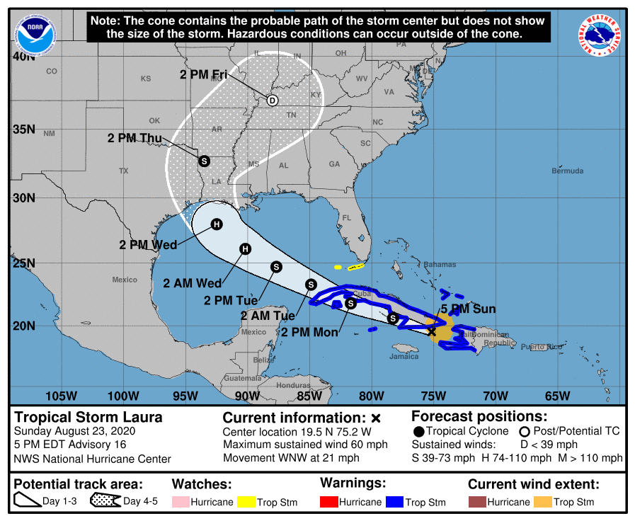
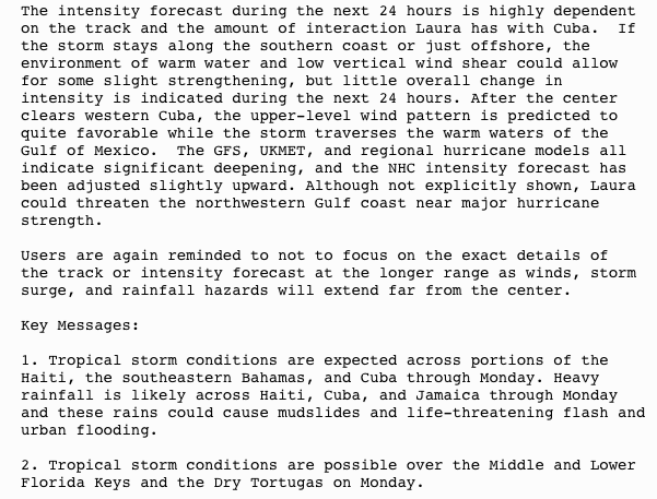
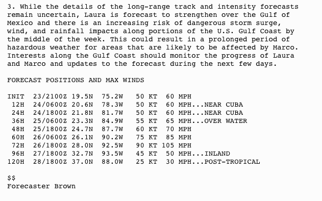
UPDATE ON TROPICAL STORM LAURA
Issued: 4p.m., 23 August 2020
Key Message:
At 4 pm, Sunday 23 August 2020, Cayman Brac and Little Cayman were placed under a Tropical Storm Warning due to the new forecast track of Tropical Storm Laura.
The forecast path for this storm drifted south as of Sunday morning, and although the latest forecast path suggests tropical force winds may still remain north of the Cayman Islands.
An associated pattern of inclement weather, including heavy showers, strong winds, and flooding of low-lying areas is expected to impact the Sister Islands overnight
On this track Tropical Storm Laura is expected to reach its closest point of approach to the Cayman Islands, near 92 miles north-northeast of Cayman Brac, by around 5am tomorrow, Monday, 24 August.
.
Hazard Management Cayman Islands advice to local population:
As a result of this residents of Cayman Brac and Little Cayman are advised to get their boats to safe harbor as quickly as possible today, and to hunker down through tomorrow evening. Residents of low-lying areas are also urged to take the necessary precautions.
N.B. Conditions expected over Grand Cayman:
Over Grand Cayman, conditions are expected to be bit more subdued with Tropical Storm Laura expected to pass about 156 miles north-northeast of Grand Cayman at its closest point of approach.
Rainfall estimate for Grand Cayman suggest accumulations of 1 inch are likely through tomorrow evening. Showers may be locally heavy at times. Higher gusts of wind are likely in and around heavy showers.
While the risk to marine interests in Grand Cayman might be low at this time, extra caution should be taken through the next 24hrs.
The National Weather Service and Hazard Management Cayman Islands will continue to monitor the storm overnight, with the next weather bulletin issued at 10 p.m.. For the latest weather information visit www.weather.gov.ky and for hurricane preparedness information visit www.caymanprepared.gov.ky.
NWS Update on Tropical Storm Laura
HMCI Advises Readiness for TS Laura
From NHC
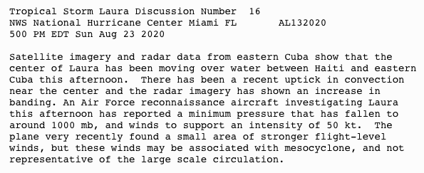
AIR FORCE HURRICANE HUNTER AIRCRAFT FINDS A SLIGHTLY STRONGER LAURA JUST SOUTH OF EASTERN CUBA… …HEAVY RAINFALL AND LIFE-THREATENING FLASH FLOODING LIKELY OVER THE DOMINICAN REPUBLIC…HAITI…CUBA…AND JAMAICA
ACCUWEATHER METEOROLOGISTS PROVIDE UPDATE ON TROPICAL STORM LAURA
AccuWeather Global Weather Center — August 23, 2020 — AccuWeather expert meteorologists provide updates to media working on stories related to Tropical Storm Laura.
Please contact [email protected] or 781.530.6863 at any time to arrange interviews with AccuWeather experts or to request the most updated graphics for print or broadcast.
WHAT: AccuWeather Interviews, Updates, Graphics Requests
WHEN: 24/7
CONTACT: [email protected]
LATEST GRAPHICS


By Jake Sojda, AccuWeather meteorologist
Tropical Storm Laura will continue to batter the islands of the northern Caribbean early this week before delivering another blow to the U.S. Gulf Coast mere days after Marco.
Laura developed in the Atlantic just a couple of hundred miles east-southeast of the northern Leeward Islands on Friday morning, shattering the record for the earliest L-named storm on record in the basin. The previous “L-storm” record was held by Luis, which formed on Aug. 29, 1995.
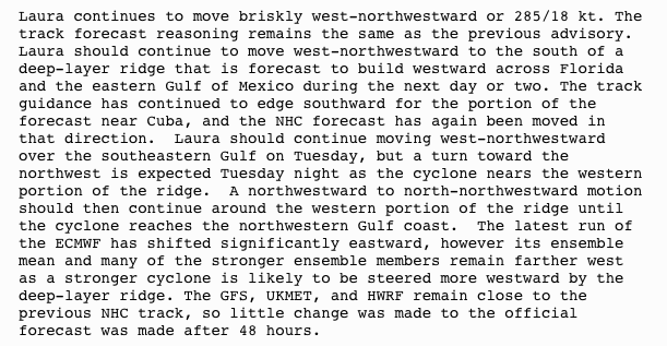
As of Sunday evening, the storm had wind speeds of 60 mph about 50 miles south of Guantanamo, Cuba and was moving to the west-northwest at 21 mph.
Tropical storm watches and warnings are in effect from Hispaniola to Cuba, the Florida Keys and central Bahamas.
Laura has already unleashed a damaging blow across the islands of the northern Caribbean, with Puerto Rico being especially hard hit.
Puerto Rico Gov. Wanda Vázquez declared a state of emergency and warned residents to stay inside as downpours and gusty winds drenched the island early this weekend. Nearly 6 inches of rain fell in some areas, prompting flood warnings. The Rio Guanajibo River near Hormigueros has risen about 6 feet as of Saturday night.
For the latest news and updates click here or visit AccuWeather.com >>
About AccuWeather, Inc. and AccuWeather.com – AccuWeather, recognized and documented as the most accurate source of weather forecasts and warnings in the world has saved tens of thousands of lives, prevented hundreds of thousands of injuries and tens of billions of dollars in property damage. With global headquarters in State College, PA and other offices around the world, AccuWeather serves more than 1.5 billion people daily to help them plan their lives and get more out of their day through radio, television, newspapers, smart phones, tablets, connected TVs, the AccuWeather Network and AccuWeather.com. Additionally, AccuWeather produces and distributes news, weather content, and video for more than 180,000 third-party websites.
As conditions quiet down in Puerto Rico with Laura moving away, rain and gusty winds will continue to spread westward with the storm through Hispaniola, the southern Bahamas, Cuba and the Florida Keys through Monday.
People across these areas should be prepared for tropical storm conditions, as an average, as the storm moves along, along with the risk for flash flooding, power outages and damage.
With the current forecast for some gusty winds and downpours to the northern Caribbean, Laura will be less than one on the AccuWeather RealImpact™ Scale for Hurricanes, a scale that rates tropical systems from less than one to 5 based on expected impacts.
Officials in the Florida Keys declared a local State of Emergency at noon on Friday, ordering a mandatory evacuation for local residents living in boats, mobile homes or any recreational vehicles, such as campers. A warning issued by Monroe County encouraged travelers visiting the area to alter their plans so they are not in the Florida Keys by noon on Sunday.
Louisiana Gov. John Bel Edwards declared a State of Emergency on Friday evening as well for the state in an effort to allow local governments assistance in preparation at a state level.
“It shouldn’t be lost on anyone that in addition to these weather threats, we still have to deal with the COVID-19 pandemic,” Edwards tweeted, explaining that personal protective equipment should be new additions to emergency kits, including masks and hand sanitizer.
Edwards also requested a Federal Emergency Declaration prior to either storm making landfall on Saturday.
“This is unlike anything we have seen, with two hurricanes expected to impact our state nearly back to back,” he said. “This may mean that people will have to shelter in place for more than 72 hours and that there may not be time to do things like restore lost power between the two storms.”
Tropical-storm-force winds of 40-60 mph with an AccuWeather Local StormMax™ of 70 mph will sweep through Hispaniola and Cuba into Monday.
While Laura may lose some wind intensity due to interaction with land as it continues its journey across the northern Caribbean, forecasters say the impacts of the storm are likely to be the same, regardless of wind intensity.
Heavy rain from the storm can average 4-8 inches with an AccuWeather Local StormMax™ of 12 inches across Hispaniola and Cuba, leading to flash flooding, washouts and mudslides.
“Some tropical-storm-force wind gusts of 40-50 mph can reach the Florida Keys Monday,” AccuWeather Meteorologist Brett Rossio said.
“Once the primary circulation of Laura emerges over the waters of the southeastern Gulf of Mexico late Monday into Tuesday, environmental conditions will be more favorable for strengthening, and Laura is expected to become a hurricane prior to reaching the Gulf Coast,” AccuWeather Senior Meteorologist Rob Miller said.
CLICK HERE FOR THE FREE ACCUWEATHER APP
The forecast track of Laura is based on the anticipated strengthening and westward extension of the Bermuda-Azores high pressure area, which will push the storm into the central Gulf of Mexico.
Should the high fail to strengthen and extend westward, there would be room for an earlier northward turn, but forecasters say the chance of this scenario panning out is rather low at this point. In turn, if the high expands farther west than currently forecast, this could push Laura into the western Gulf Coast, and possibly put Houston at risk for more severe impacts.
People along the central Gulf Coast may have to deal with two landfalling hurricanes just days apart, following Marco’s anticipated ramp up to a hurricane and landfall along the Louisiana coastline early this week.
“Rainfall from Laura may fall across the same places that received tremendous rainfall from Marco, further exacerbating the flooding situation along the Gulf Coast,” Rossio said.
Damaging winds will reach the central Gulf Coast later Tuesday into Wednesday, with wind gusts of 80-100 mph near where Laura makes landfall with an AccuWeather Local StormMax™ wind gust of 110 mph.
“These winds can cause power outages and damage to weak structures and trees,” Rossio said.
All residents along the U.S. Gulf Coast will need to closely monitor the progress of Marco and Laura and begin making preparations now, along with following evacuation orders from local officials.
For more on this story go to: ACCUWEATHER