Newly-formed Tropical Storm Marco to eye Mexico, then US
By Jake Sojda, AccuWeather meteorologist From AccuWeather News
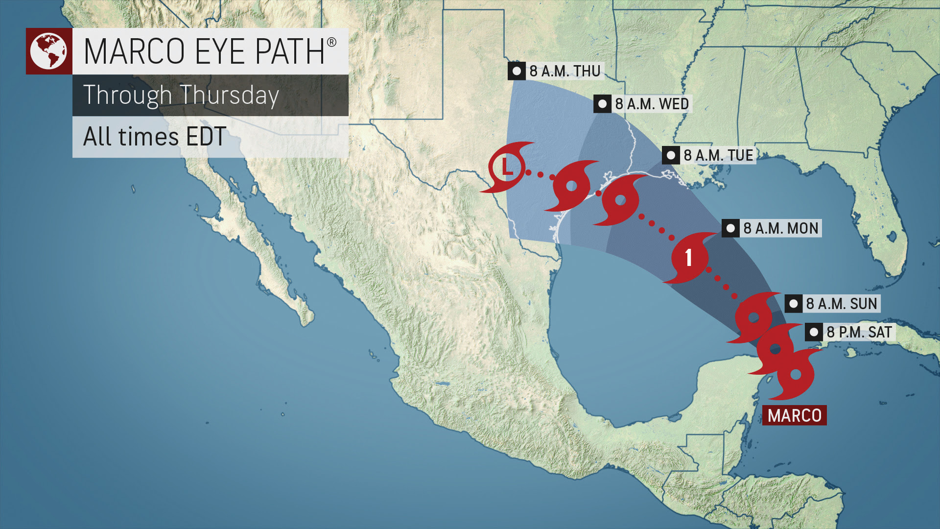
Tropical Depression 14 strengthened to Tropical Storm Marco over the warm waters of the northwestern Caribbean on Friday night. The storm was located about 105 miles east-southeast of Cozumel, Mexico, and had maximum sustained winds of 65 mph with a north-northwest movement at 12 mph at 11 a.m. EDT Saturday.
Forecasters warn that residents along the western Gulf Coast of the U.S. should keep a close eye on the system’s strength and forecast track and make storm preparations now.
Louisiana Gov. John Edwards tweeted late Thursday that officials are monitoring two systems that could enter the Gulf of Mexico early next week and urged residents to gather a plan and consider adding items to guard against the coronavirus pandemic to storm kits. “I want to urge everyone to prepare for whatever may come and to get a game plan,” Edwards said.

A tropical storm warning and hurricane watch have been posted for the Mexico coastline from Punta Herrero to Cancun.
“Marco is in a very favorable environment for continued strengthening right up until landfall in the eastern Yucatan Saturday evening,” said AccuWeather Hurricane Expert Dan Kottlowski, adding that very warm waters and wind patterns will remain conducive for further intensification.
However, if Marco passes just off the coast of the Yucatan Peninsula it can continue to strengthen into Saturday night.
Marco became the tenth storm in 2020 to go down in the record books for the basin. Marco beat Hurricane Maria from the 2005 season, and that storm wasn’t given the name Maria until Sept. 2. This was the second Atlantic record set late this week, as Laura claimed the title for the earliest L-named storm on record when it was developed at 9:00 a.m. EDT Friday. Laura was located just east of the northern Leeward Islands when it was named.
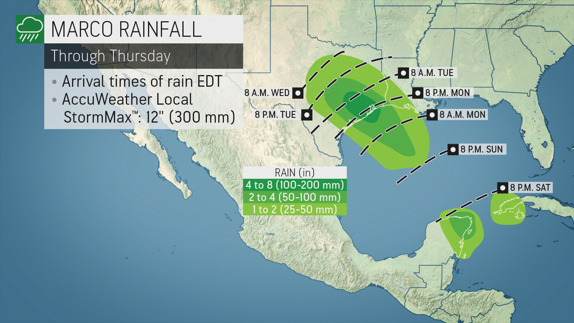
Heavy rain and gusty winds will continue to spread into the northeastern Yucatan Peninsula and western Cuba as Marco heads northwest this weekend.
Through this weekend, a large swath of rainfall amounts of 1-2 inches (25-50 mm) are expected across the Yucatan and western Cuba. Heavier totals are expected near the northeastern tip of the Yucatan Peninsula, including Cancun, where 2-4 inches (25-50 mm) is expected.
CLICK HERE FOR THE FREE ACCUWEATHER APP
The mountainous portions of the region will be particularly susceptible to some of the highest rainfall totals. With a lot of rain in just a bit of time, the ground will become saturated and unstable quite quickly, leading to the risk for mudslides.
After the system crosses the Yucatan Peninsula this weekend, it is predicted to emerge in the Gulf of Mexico. Once in the Gulf of Mexico, it is expected to continue strengthening and could become a hurricane before threatening portions of the U.S. Gulf Coast next week.
As the system strengthens in the Gulf, heavier rainfall totals are expected to occur in the southern U.S., with a swath of 4-8 inches and an AccuWeather Local StormMax™ of 12 inches of rain anticipated from coastal southwest Louisiana into southeast Texas. This heavy rainfall will occur regardless of the strength of Marco as it nears landfall.
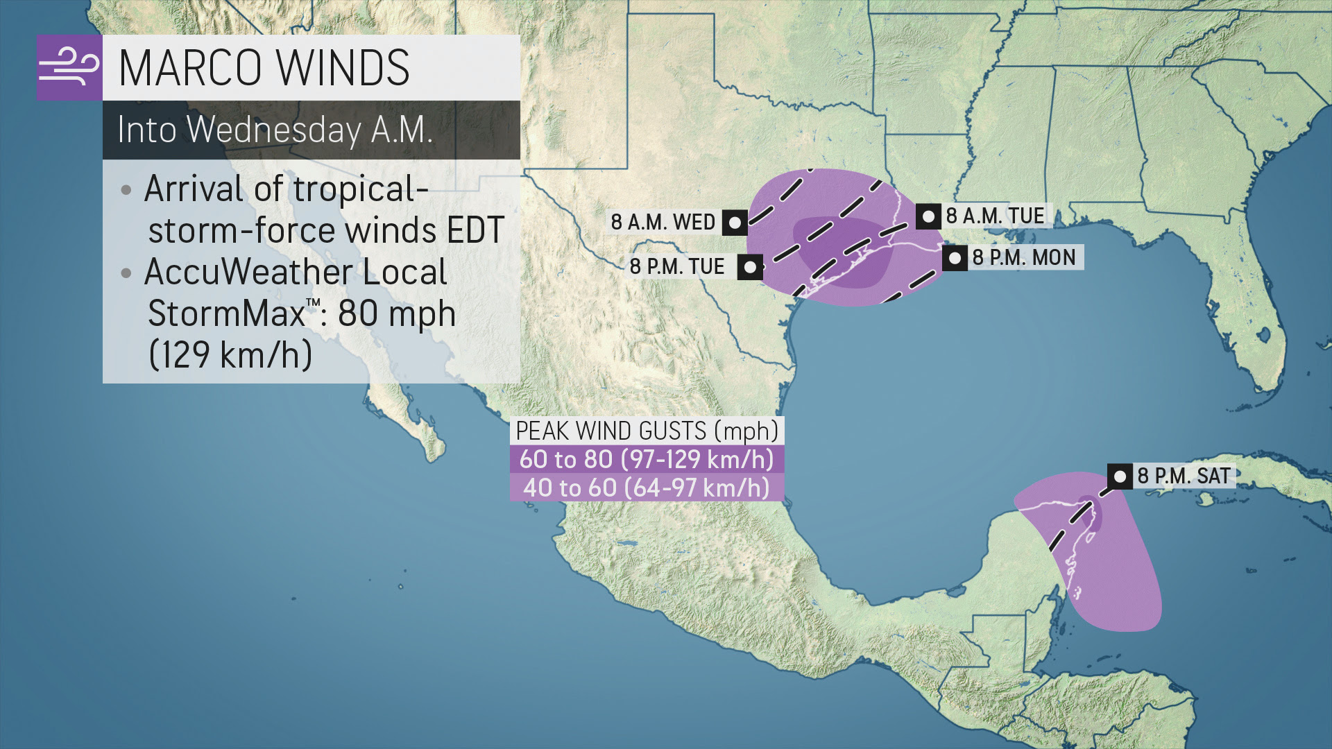
Damaging winds are also expected, especially in exposed windward locations like coastal areas around and north of the center of the storm. These areas are most likely to be impacted by destructive onshore winds. Should the storm remain stronger, these areas could also experience coastal flooding.
With these anticipated impacts from rain and wind, this system will be less than one for the Yucatan Peninsula on the AccuWeather RealImpact Scale™ for Hurricanes, a six-point scale from less than one to 5 that rates tropical systems based on impacts.

The complexity of the weather pattern over North America and the Gulf of Mexico means the final track of this tropical system early next week as it heads toward the U.S. is still somewhat uncertain.
“A dip in the jet stream over the western Gulf of Mexico this weekend and the expectation of Tropical Storm Laura to strengthen and move into the Gulf early next week as well make the forecast for both of these systems a bit more difficult,” Kottlowski said.
The circulations of both systems could interact with each other, altering their respective tracks and intensities, as they draw closer in proximity.
“Whichever storm becomes stronger faster is likely to win out and remain the stronger storm as they enter the Gulf of Mexico, while the other one weakens,” Kottlowski explained. “It is unlikely that we actually see two hurricanes make landfall in that close proximity and near the same time.”
However, forecasters say that residents all along the Gulf Coast should prepare for hurricane impacts. Even if the systems never reaches hurricane strength, hurricane-force wind gusts and significant flooding will remain threats.
At this point, the greatest impacts from rain, wind and storm surge flooding are expected to be along and near southeastern Texas and the Louisiana coastline.
Oil and gas rigs are most concentrated in the central and western two-thirds of the Gulf of Mexico, with refineries in the Houston and Galveston area and around New Orleans. “Two potential [Gulf of Mexico] storms could certainly keep the rigs offline for a few days,” according to AccuWeather Senior Meteorologist Dale Mohler.
For more on this story go to: ACCUWEATHER


