NEW UPDATE – ISAAC DISSIPATES – Isaac may become a hurricane after threatening Jamaica, impacting Lesser Antilles

From HMCI Sep 15 2018
Great news – The NHC has advised that Isaac has dissipated and has now issued its last advisory on the remnants of Isaac!
The Cayman Islands National weather service will continue to monitor the remnants of Isaac as it moves over the central Caribbean. The local forecast indicates an 80 % chance of rainfall on Tuesday, Wednesday and Thursday which at times could be locally heavy and lead to flooding of low lying areas. Also for the same time period – southeasterly winds 10 to 15 knots with height gusts, and Wave heights of 3 to 5 feet with larger swells, especially for the south and southeast of Grand Cayman. Small craft are advised to exercise caution over open water (on Tuesday, Wednesday and Thursday)
Latest from NHC ISAAC DISSIPATES SAT SEP 16
Remnants Of Isaac Discussion Number 31
NWS National Hurricane Center Miami FL AL092018
500 AM EDT Sat Sep 15 2018
A NOAA Hurricane Hunter aircraft investigated Isaac over the past
few hours and was unable to identify a well-defined center. The
plane found multiple small and poorly-defined circulations embedded
within a larger area of weak and variable winds, well to the south
of the previous estimated center location. The plane also found that
the minimum pressure has risen to around 1006 mb. All of this data
confirmed what two late-arriving ASCAT overpasses from earlier this
evening indicated, that Isaac has opened up into a southwest to
northeast oriented trough. Since Isaac does not have a well-defined
center, it no longer meets the NHC definition of a tropical cyclone
and this is the last advisory.
The strongest SFMR winds found by the plane were around 30 kt,
mainly to the north of the deep convection, so the intensity has
been set at that value. Although some of the regional hurricane
models suggest that small short-lived circulations like the ones
found by the plane could temporarily spin up within the larger
envelope of the tropical wave over the next several days, none of
the dynamical models currently show any significant redevelopment of
Isaac. The wave will likely continue westward across the Caribbean
Sea over the next few days, producing gusty winds and occasional
heavy rains over portions of Hispaniola and Jamaica.
This is the last public advisory issued by the National Hurricane
Center on Isaac. Additional information can be found in High Seas
Forecasts issued by the National Weather Service, under AWIPS header
NFDHSFAT1, WMO header FZNT01 KWBC, and available online at
https://ocean.weather.gov/shtml/NFDHSFAT1.shtml.
FORECAST POSITIONS AND MAX WINDS
INIT 15/0900Z 14.8N 70.8W 30 KT 35 MPH
12H 15/1800Z…DISSIPATED
$$
Forecaster Zelinsky
Isaac Regains Tropical Storm Strength (Fri SEP 14)
From Cayman Islands Hazard Management
At 4 PM – News in from the National Hurricane Centre confirms Isaac has regained Tropical Storm strength. The centre of Isaac was located near latitude 15.3 North, longitude 67.3 West. Isaac is moving west near 14 mph with maximum sustained winds of 40 mph. A westward track with some decrease in forward speed is expected for the next few days, followed by a possible turn to the west-northwest late Sunday. On this track the storm could be close to the Cayman Islands by Monday morning.
Little change in strength is forecast during the next 36 hours but Isaac is currently forecast to weaken to a Tropical depression on Sunday and degenerate into an open wave on Monday.
It should be noted that there remains significant uncertainty in the intensity forecast for Isaac and the NHC is already advising Isaac could deliver 4 to 6 inches of rainfall to Jamaica with the possibility of flash floods to that Island.
Tropical Storm force winds currently extend outwards 45 miles for the centre of circulation and the estimated minim central pressure is 1003 mb
Residents in the Cayman Islands are urged to closely follow the progress of Tropical Storm Isaac as changes to the forecast track and intensity are possible.
RECOMMENDED ACTIONS
The Cayman Islands Government is following the current forecast of the NHC which indicates Isaac will weaken to a Tropical Depression then an open wave, however local residents are asked to closely follow the official forecasts over the weekend and maintain high levels of preparedness.
Update from NHC:
 Tropical Storm Isaac Discussion Number 29
NWS National Hurricane Center Miami FL AL092018
500 PM AST Fri Sep 14 2018
It has been a very interesting flight of the NOAA Hurricane Hunter
aircraft this afternoon. Dropsonde and SFMR data indicate that the
maximum winds are around 35 kt again, and the pressure has fallen
to about 1002 mb. However, the system is tilted southward with
vertical height due to northerly shear, and scatterometer and
Hurricane Hunter tail-Doppler radar data indicate the system is
elongated from northeast to southwest, albeit closed. Note that the
plane was unable to sample the southwestern quadrant well because of
strong convection and intense lightning, so the flight-level winds
showing no circulation were unrepresentative.
 The intensity forecast hasn’t gotten any easier with Isaac.
Vertical shear is expected to decrease a bit more, which might
diminish the effects of dry air seen on water vapor images around
the cyclone. However, the GFS and ECMWF continue to insist that
Isaac will degenerate into a wave within the next 2 or 3 days, which
is almost unanimously supported by their respective ensemble
members. This is the solution that the official forecast follows.
It should be noted that none of the global models show pressures
this low now with Isaac, except the UKMET, and that model is the one
that holds onto the circulation the longest. The reality of the
situation is that the long-term future of Isaac is cloudy, and the
best advice is just to follow NHC advisories every 6 hours to see
if we gain any confidence.
Isaac is moving westward at about 12 kt. A ridge over the
southwestern Atlantic should steer the cyclone westward over the
weekend then west-northwestward early next week as Isaac reaches a
weaker portion of the ridge. Just like yesterday, a stronger system
would likely turn more to the west-northwest earlier, moving
closer to Jamaica. Since the system is forecast to be weaker, the
forecast lies on the westward and faster side of the guidance, and
should also be considered low confidence since it depends on the
intensity. Interests in Jamaica should monitor the progress of the
Isaac.
FORECAST POSITIONS AND MAX WINDS
INIT 14/2100Z 15.3N 68.2W 35 KT 40 MPH
12H 15/0600Z 15.4N 70.1W 35 KT 40 MPH
24H 15/1800Z 15.4N 72.2W 35 KT 40 MPH
36H 16/0600Z 15.7N 74.2W 35 KT 40 MPH
48H 16/1800Z 16.2N 76.3W 30 KT 35 MPH
72H 17/1800Z 17.5N 80.0W 25 KT 30 MPH
96H 18/1800Z…DISSIPATED
$$
Forecaster Blake
By Courtney Spamer, AccuWeather meteorologist, By Renee Duff, AccuWeather meteorologist From Accuweather
Tropical Storm Isaac, after plowing through the Lesser Antilles with flooding rain and gusty winds, will threaten the western Caribbean by next week.
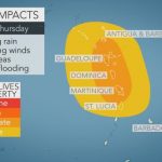
Isaac will pass through the Lesser Antilles on Thursday near Dominica and Martinique then continue on a westward path through the Caribbean into Sunday.
Tropical storm warnings continued on Thursday for the islands of Martinique, Dominica and Guadeloupe.
Wind gusts in excess of 80 km/h (50 mph) will be found on these islands, especially in the higher elevations and at the windward-facing coasts.
Even with the storm’s brisk movement, rainfall can be heavy enough to trigger localized flooding. Tree and power line damage will also be possible.
After briefly reaching hurricane strength, Isaac weakened to a tropical storm on Monday night and is expected to maintain tropical storm strength through the end of the week.


As Isaac weakened earlier this week, it became a broader storm, allowing some gusty showers to reach farther away from the center.
The islands of Montserrat, Antigua and and St Lucia may get these showers in addition to rough seas and strong rip currents into early Friday.
Small craft may need to remain in port into Friday, as seas may remain dangerous until Isaac pulls away.
Many of these islands are still rebuilding following Hurricane Maria, which crossed the Lesser Antilles and moved over Puerto Rico almost a year ago.
Beyond the Lesser Antilles, Isaac is forecast to track south of Puerto Rico and Hispaniola. An uptick in shower and thunderstorm activity is expected in these areas late in the week and over the weekend.
The southern-facing coastlines may have rough seas and well as stronger rip currents.
Isaac impacts 9.12 AM
Residents and visitors of Jamaica will need to closely monitor the track of Isaac, as well.
The storm may pass very close to the island by the end of the weekend, bringing with it heavy rain and gusty winds.
Those on the island of Jamaica should make sure to have an emergency preparedness plan in place if you do not already have one.
The track of Isaac becomes more uncertain late in the weekend.
“Waters remain very warm over the western Caribbean and Gulf of Mexico,” said AccuWeather Senior Meteorologist Alex Sosnowski.
“Provided wind shear is low, there is the potential for Isaac to gain strength and possibly ramp up to a hurricane before approaching any land in along the U.S. Gulf Coast next week,” Sosnowski added.
If Isaac is unable to overcome the area of disruptive winds in the atmosphere, the environment instead could weaken Isaac to just a tropical wave before reaching the Yucatan Channel.
Should this be the case, lingering tropical moisture could bring heavier rains to the Yucatan Peninsula of Mexico as well as the western half of Cuba early next week.
Stay up-to-date with the latest tropical developments by downloading the free AccuWeather app.
IMAGE:
IsaacLesserThur
For more on this story go to; https://www.accuweather.com/en/weather-news/isaac-to-batter-lesser-antilles-with-torrential-rain-puerto-rico-hispaniola-on-alert/70006013
Related:
Tropical Storm Isaac
From Hazard Management Cayman Islands
At 4 PM Wed 12th Sep the centre of Tropical Storm Isaac was located near latitude 15.4 North, longitude 56.6 West. Isaac is moving toward the west near 20 mph, and this general motion is expected to continue for the next few days. On the forecast track, Isaac is anticipated to move near or over the central Lesser Antilles on Thursday (13th September), move into the eastern Caribbean Sea Thursday, and move into the central Caribbean Sea by the weekend.
Maximum sustained winds remain near 60 mph with higher gusts. Some weakening forecast during the next 48 hours. Tropical-storm-force winds extend outward up to 175 miles from the centre. The estimated minimum central pressure is 1003 mb (29.62 inches).
Key Points:
• Tropical Storm Isaac is expected to remain at tropic storm intensity when it moves across the Lesser Antilles by tomorrow bringing potentially life –threatening flash flooding to that area.
• Residents of the Cayman Islands should continue to monitor the progress of Tropical Storm Isaac as the official NHC forecast now places Isaac near the Cayman area by Monday.
• There is a reasonably high degree of uncertainty in the current forecast track and intensity.
Recommended Actions:
“At this time, Tropical Storm Isaac is not considered an imminent threat to the Cayman Islands but that could change,” explained the Honourable Tara Rivers, Minister responsible for Hazard Management Cayman Islands, “as we enter the more active phase of the hurricane season residents should have their hurricane preparedness plans well established and in place, and be ready to complete final arrangements such as shuttering and moving to safe shelter if necessary.”
ARE YOU PREPARING?
· Come to a decision about where you will shelter during a storm
· Ensure that travel documents and insurance policies are up to date
· Place all vital documents in a waterproof ‘grab and go’ container
· Service your generator if you have one
· Check your shutters, make sure that they fit and you have all the parts
· Trim back trees
· Store non-perishable food and water
· Assemble an emergency supplies kit
· Stock up now on emergency supplies that can be used after a hurricane. These supplies should include a first aid kit, survival kits for the home, automobile, and workplace, flashlight and batteries, garbage bags, toilet paper, soap, can opener, work gloves, battery operated radio, and emergency water and food.
· Store enough supplies to last at least 3 days. For additional information about the emergency supply kit pick up a copy of the Hurricane Information Kit which is available at the Government Administration Building on Elgin Avenue, or alternatively you can download a copy on www.Caymanprepared.ky;
WHAT SHOULD YOU HAVE IN YOUR DISASTER SUPPLY KIT?
· Water – at least 1 gallon daily per person for 3 to 7 days
· Food – at least enough for 3 to 7 days
· Non-perishable packaged or canned food / juices / vitamins
· Foods for infants or the elderly
· Snack foods / high energy good such as crackers / peanut butter / jelly
· Non-electric can opener / aluminum foil / zip lock bags
· Cooking tools / fuel / Sterno / charcoal grill / pots and pans
· Paper plates / plastic utensils / plastic cups / garbage bags
· Blankets / Pillows, etc.
· Clothing – rain gear / sturdy shoes
· Whistle – to signal for help if needed
· Two coolers – One for food storage the other for ice
· First Aid Kit / Medicines / Prescription Drugs – include hand sanitizer, sunscreen, insect repellant and lip balm, extra eye glasses, contact lens cleaner, hearing aid batteries
· Special Items – for the elderly, the disabled and for babies, bottles, pacifier, diapers, formula, sterile water, clothing, bedding, toys etc)
· Toiletries / Hygiene items / Moisture wipes – Toilet paper, paper towels, deodorant, soap, toothbrush, toothpaste
· Flashlight / Batteries / Light sticks / Candles / Lighter or Matches
· Radio – Battery operated
· Telephones – Fully charged cell phone with extra battery and get a car charger
· Cash (with some small bills) – Banks and ATMs may not be available for extended periods
· Keys – Make at least one extra set of keys for your residence and vehicle
· Toys, Books and Games
· Paper / Pens / Pencils
· Important documents – Store in a waterproof or watertight container. Include passports, driver’s license, vehicle registration and title, birth and marriage certificates, insurance policies, medical and immunization records, will and power of attorney documents, bank account numbers, land and property titles, a list of important phone numbers etc. You may want to copy your computer hard drive to a portable disk or thumb drive as well and store this in your container.
· Tools – keep a set with you during the storm
PET CARE ITEMS
· Immunization records / medications
· Ample supply of food and water / water and food bowls
· A carrier or cage / trash bags for handling waste / newspaper
· Muzzle (if needed) collar and leash / cat litter / scoop
·
WHAT SHOULD YOU HAVE IN YOUR NON-PERISHABLE EMERGENCY SUPPLIES KIT?
· Basic Tool Kit –include hammer, pliers, wrenches, screwdrivers
· Tarps – or roll of plastic sheeting
· Duct Tape
· Work Gloves and rubber gloves
· Unscented bleach to clean up and disinfect water
· Plastic Garbage Bags
· Garbage can or bucket with tight fitting lid for carrying water or using as an emergency toilet
· Jerry Container for gasoline
RECOMMENDED ACTIONS ‘WATCH’ AND ‘WARNING’
At the Watch Phase (48 hours or less before the onset on Tropical Storm / Hurricane force winds):
• Board up all windows with shutters.
• Check batteries and stock up on canned food, cash, flashlights, garbage bags, toilet paper, first aid kit / medical supplies.
• Ensure that your battery operated radio is working.
• Store a gallon of water per person per day to last a week in sealed containers. Additional water supplies can be stored in clean bathtubs and sinks but this supply should not be considered an alternative to water stored in containers.
• Bring in outside objects (e.g., garbage cans, lawn furniture, bicycles).
• Start making ice (in jugs and containers) to help keep items cool in the freezer, and also so food and ice can be transferred to a cooler in the event that the power remains out for an extended period.
• Fuel up vehicles and get them to higher ground if possible.
• Secure boats.
• Listen closely to the advice of local officials, and evacuate if told to do so.
Warning Phase (36 hours or less before landfall):
• Turn your refrigerator or freezer to the coldest setting and open only when necessary. If you lose power, food will last longer. Keep a thermometer in the refrigerator to be able to check the food temperature when the power is restored.
• Turn on your TV/radio, and check regularly in order to get the latest weather updates and emergency instructions
• Charge cell phones to ensure you will have a full battery in case you lose power.
• Store valuables, personal papers, important documents, computer back-ups in waterproof containers, use large industrial strength garbage bags to wrap up computer, paintings etc. and move to the highest level of your home if you do not plan to take them with you if you are sheltering elsewhere.
• Unplug small appliances. Small appliances may be affected by electrical power surges that may occur as the storm approaches.
• Have a supply of flashlights and extra batteries handy. Avoid using open flames (candles and kerosene lamps) as a source of light. Flashlights provide the safest emergency lighting source. Kerosene lamps require a great deal of ventilation and are not designed for indoor use.
• Listen to the advice of local officials, and evacuate if told to do so.
• Seek shelter if you do not plan to stay in your home.
• If you are not advised to evacuate, stay indoors and away from windows.
• Stay away from flood waters; never drive through them.
• Be aware of the calm “eye”; the storm is not over.
If evacuating your home to a Shelter.
• Secure your home by unplugging appliances and turning off electricity and the mains water valve.
• If time permits and you live area prone to flooding, move furniture and other vulnerable items to a higher floor. If you live in a single story dwelling consider lifting furniture and appliances such as refrigerators etc. up by placing on concrete blocks.
• Lock up your home and leave.
ITEMS TO TAKE WITH YOU IF YOUR ARE NOT STAYING AT HOME OR IF GOING TO A SHELTER:
• Bring preassembled emergency supplies and protective clothing.
• First aid kit and prescription medications.
• Baby food and diapers.
• Non-perishable food items and bottled water.
• Cards, games, books.
• Change of clothes.
• Toiletries.
• Battery-powered radio and extra batteries.
• Flashlight (one per person) and extra batteries.
• Blankets or sleeping bags and pillow.
• Identification.
• Valuable papers (copies of insurance papers, passports, and other essential documents).


