Cayman: Hurricane Ian Public Advisory
SUMMARY OF 800 AM EDT…1200 UTC…INFORMATION
———————————————-
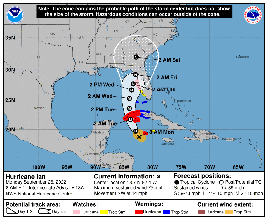
LOCATION…18.7N 82.4W ABOUT 90 MI…145 KM WSW OF GRAND CAYMAN ABOUT 275 MI…440 KM SE OF THE WESTERN TIP OF CUBA MAXIMUM SUSTAINED WINDS…75 MPH…120 KM/H PRESENT MOVEMENT…NW OR 325 DEGREES AT 14 MPH…22 KM/H MINIMUM CENTRAL PRESSURE…981 MB…28.97 INCHES
DISCUSSION AND OUTLOOK
———————-
At 800 AM EDT (1200 UTC), the center of Hurricane Ian was located near latitude 18.7 North, longitude 82.4 West. Ian is moving toward the northwest near 14 mph (22 km/h). A turn toward the north-northwest is expected later today, followed by a northward motion on Tuesday with a slightly slower forward speed. A turn toward the north-northeast is forecast on Tuesday night or early Wednesday. On the forecast track, the center of Ian is expected to pass near or west of the Cayman Islands today, and near or over western Cuba tonight and early Tuesday. Ian will then emerge over the southeastern Gulf of Mexico on Tuesday, pass west of the Florida Keys late Tuesday, and approach the west coast of Florida on Wednesday. Maximum sustained winds are near 75 mph (120 km/h) with higher gusts. Rapid strengthening is expected during the next day or so, and Ian is forecast to become a major hurricane tonight when it is near western Cuba. Hurricane-force winds extend outward up to 15 miles (30 km) from the center and tropical-storm-force winds extend outward up to 90 miles (150 km). The estimated minimum central pressure is 981 mb (28.97 inches) based on dropsonde data from the NOAA and Air Force Hurricane Hunters.