Tropical rain and wind impacts may reach the Southeast US early next week
AccuWeather Public Relations

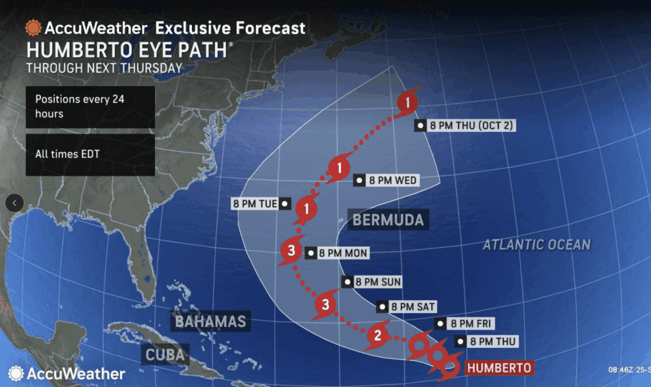
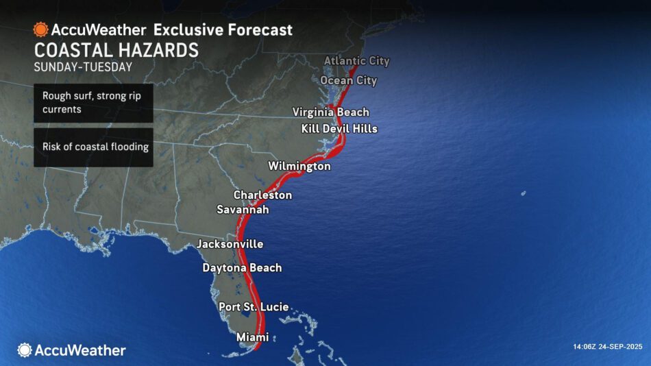
Humberto is forecast to strengthen to a major hurricane that is expected to produce rough surf and rip currents reaching the Bahamas and much of the U.S. East Coast starting Sunday
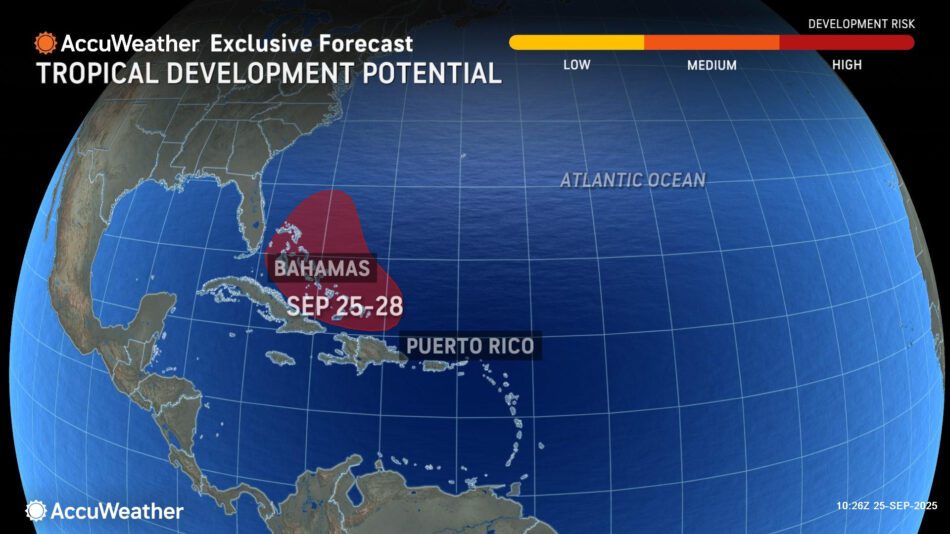
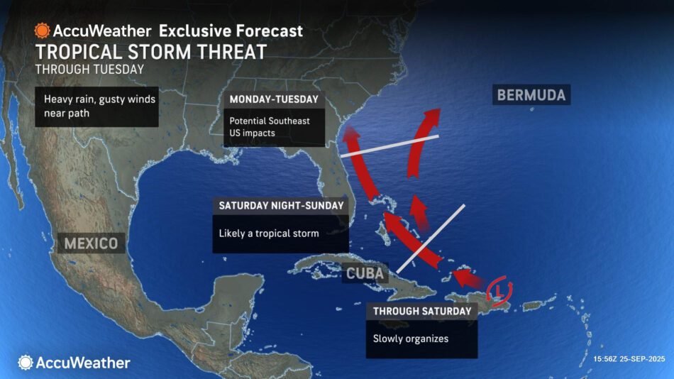
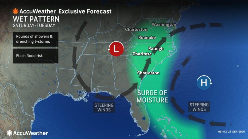
> A tropical rainstorm moving toward the Bahamas has a high risk of developing into a tropical storm that may bring rain and wind impacts to the Southeast U.S. as early as Monday.
AccuWeather® Global Weather Center – Sept. 25, 2025 – Humberto is forecast to intensify into a powerful hurricane and is expected to pass between Bermuda and the U.S. East Coast early next week.
AccuWeather® hurricane experts warn that a tropical wave near Hispaniola has evolved into a tropical rainstorm. It is moving toward the Bahamas and may bring direct tropical impacts to the East Coast early next week.
“Humberto is slowly gaining wind intensity as it battles some disruptive wind shear. As the shear eases and the storm moves northwest, Humberto is forecast to intensify into a major hurricane over the weekend or early next week. At this time, Humberto is expected to track between the U.S. East Coast and Bermuda, bringing some wind and rain to the islands early next week,” AccuWeather® Lead Hurricane Expert Alex DaSilva said.
AccuWeather® hurricane experts say a tropical rainstorm moving toward the Bahamas poses a potentially greater threat to the southeastern United States in the coming days. The next name on the list of 2025 Atlantic hurricanes is Imelda.
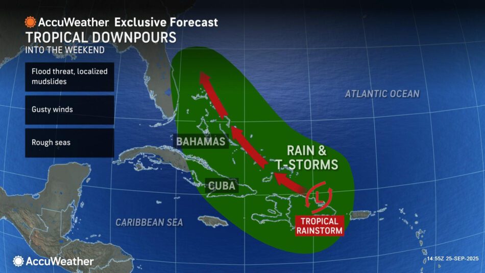
“The tropical rainstorm is moving across the Dominican Republic and toward the Bahamas. Interaction with land is limiting development, but this tropical rainstorm is expected to organize once it reaches the warm waters of the Bahamas. Downpours from the tropical rainstorm will soak the Dominican Republic and islands across the Bahamas,” DaSilva explained.
AccuWeather® hurricane experts say this tropical rainstorm may quickly gain wind intensity and has the potential to become a hurricane later this weekend or early next week.
“The forecast for the tropics this week is complex. We do not see two storms develop this close in proximity very often. There are several potential scenarios for the tropical rainstorm in the Bahamas. If this tropical rainstorm develops and does not interact with Humberto, it may track northward toward the East Coast,” DaSilva said. This scenario could bring flooding rainfall and gusty winds to parts of the East Coast, especially the Carolinas and Virginia. Storm surge impacts along the coastline and inlets are also possible.”
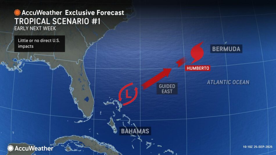
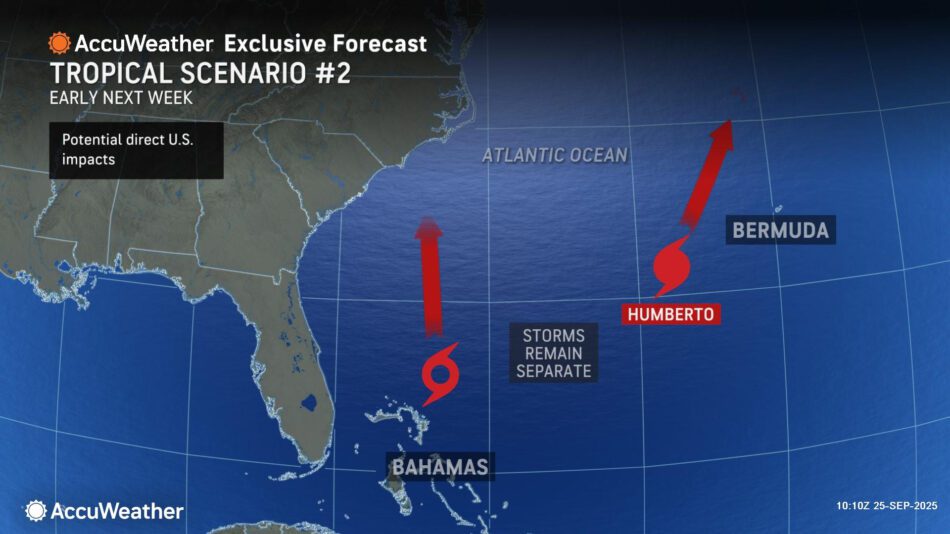
“If this evolving storm has less wind intensity than Humberto, it may be guided to the east and enveloped or even absorbed into Humberto. This scenario would limit tropical impacts from reaching the East Coast,” DaSilva said.
AccuWeather uses the term “tropical rainstorm” to describe certain tropical systems that may bring significant impacts from rain or wind before they are officially classified as a tropical depression or storm in order to raise public awareness of their disruptive, damaging and dangerous potential.
At this time, AccuWeather® hurricane experts believe the scenario potentially bringing impacts to the Southeast U.S. is more likely than other potential outcomes. However, there remains greater-than-average uncertainty in the forecast. People and businesses across the Bahamas, Bermuda and southeastern United States are encouraged to frequently check AccuWeather® forecast updates in the coming days.
AccuWeather® hurricane experts say there is a low possibility interaction between the two storms could lead to a phenomenon known as the Fujiwhara Effect.
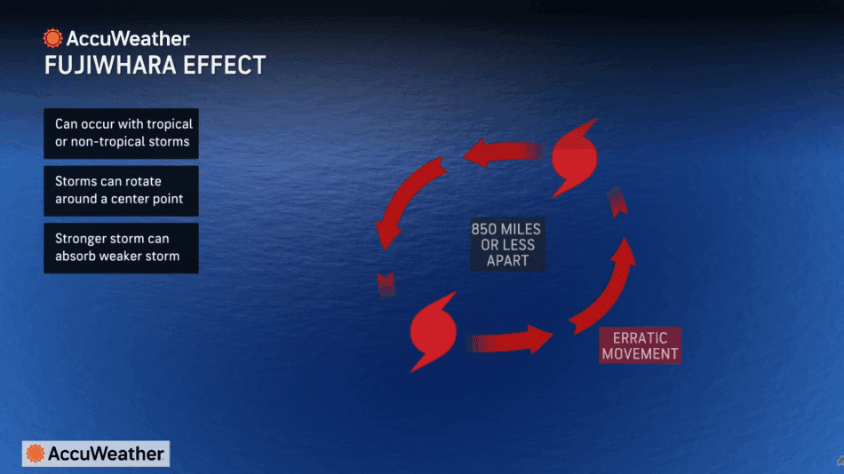
This rare storm behavior is named after Japanese meteorologist Sakuhei Fujiwhara, who first described it in a 1921 research paper. The Fujiwhara Effect occurs when two storms in close proximity begin to rotate around a center point, similar to the teacup ride at an amusement park or ballroom dancers moving in unison. This phenomenon is more common in the western Pacific and rare in the Atlantic.
If such an interaction occurs, the track and intensity of each storm may be impacted, potentially resulting in a prolonged period of heavy rainfall across parts of the southeastern United States. Another possible scenario is a weaker storm closer to the U.S. coastline that could be absorbed by a more intense Humberto, leading to fewer direct impacts in the U.S.
“Very rough surf and dangerous rip currents are expected across the Bahamas and U.S. East Coast starting Sunday, regardless of how these two storms evolve and potentially interact,” DaSilva said.
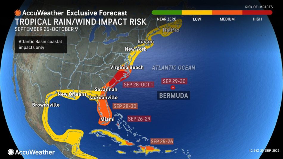
AccuWeather® hurricane experts say there is a high risk of tropical rain and wind impacts before the end of the month across the Bahamas and Bermuda, as well as parts of South Carolina and North Carolina.
- Additional tropical waves moving off Africa over the next several weeks will also have to be watched for possible development.
- AccuWeather® hurricane experts reduced the maximum number of named storms and hurricanes forecast to develop this year due to the unusual midseason lull.
- The AccuWeather® 2025 Atlantic Hurricane Season Forecast now predicts 13-16 named storms and six to nine hurricanes.
- It is important to note that the forecast for three to six direct impacts on the U.S. has not changed, despite a slight lowering of the total number of storms and hurricanes.
bout AccuWeather, Inc. and AccuWeather.com – AccuWeather®, recognized and documented as the most accurate source of weather forecasts and warnings in the world has saved tens of thousands of lives, prevented hundreds of thousands of injuries and tens of billions of dollars in property damage. With global headquarters in State College, PA and other offices around the world, AccuWeather® serves more than 1.5 billion people daily to help them plan their lives and get more out of their day through radio, television, newspapers, smart phones, tablets, connected TVs, the AccuWeather® Network and AccuWeather.com. Additionally, AccuWeather® produces and distributes news, weather content, and video for more than 180,000 third-party websites.
There is no better place to track the storm and its impacts than AccuWeather.com, the free AccuWeather mobile apps, the AccuWeather® TV Network or AccuWeather® partner outlets.