Rough surf and wind impacts from Hurricane Erin expand as the storm nears U.S. and Bermuda
AccuWeather® hurricane experts say waves of 15-20 feet, storm surge of 3-6 feet and life-threatening rip currents are expected along the Outer Banks
Tropical-storm-force winds will likely extend outward more than 230 miles from the center of the storm by the middle of this week
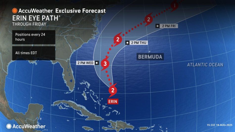
AccuWeather® Global Weather Center – Aug. 19, 2025 – AccuWeather® hurricane experts are urging people along the mid-Atlantic coast to follow evacuation orders and exercise extreme caution at the beach as Hurricane Erin approaches the United States. Erin is forecast to track 150-250 miles east of North Carolina’s Outer Banks this week, with its closest approach to the U.S. coastline Thursday.
“People should follow evacuation orders. Hurricane Erin is expected to blast parts of the Outer Banks with 60-to-80-mph wind gusts, several feet of storm surge and waves reaching 15-20 feet. Coastal flooding and surge could wash away dunes and leave roads submerged,” AccuWeather Lead Hurricane Expert Alex DaSilva warned. “These dangerous conditions could leave roads impassable for days, making rescues and evacuations nearly impossible. Some beach houses in areas battling beach erosion could be damaged or even collapse into the rough surf this week.”
Impacts expected in the Caribbean
Hurricane Erin is forecast to move north then turn to the northeast late Wednesday.
“Hurricane Erin is losing wind intensity as it encounters more dry air and disruptive wind shear,” DaSilva said. “Erin is a remarkably powerful storm. It exploded into a Category 5 hurricane with winds reaching 160 mph over the weekend. Erin has since lost wind intensity, but the size of the storm has grown dramatically. Tropical-storm-force winds will likely extend outward more than 230 miles from the center of the storm.”
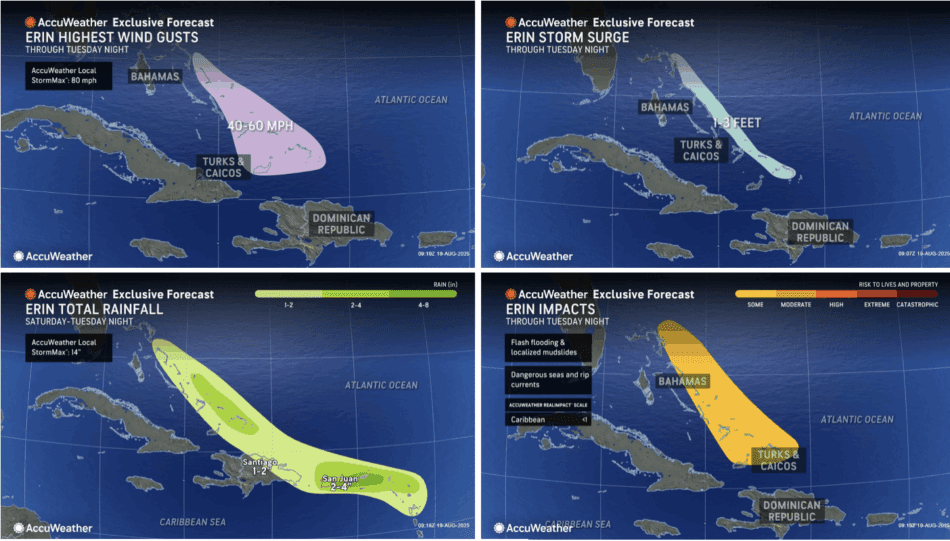
Heavy rain and strong winds will continue to affect the Turks and Caicos and the Bahamas through Tuesday night. Rainfall of 1-2 inches is expected across northern parts of the Dominican Republic, while 2-4 inches are possible in the Turks and Caicos Islands and parts of the southeastern Bahamas. An AccuWeather Local StormMax™ of 14 inches is possible. This rain could trigger flash flooding and mudslides in the higher terrain.
Erin will bring wind gusts of 40-60 mph across the Turks and Caicos and the southern and eastern Bahamas through Tuesday night. Stronger gusts up to 60-70 mph are possible in the Turks and Caicos, with an AccuWeather Local StormMax™ of 80 mph.
Hurricane Erin will also produce a storm surge of 1-3 feet from the Turks and Caicos Islands to San Salvador through Tuesday night. This surge may damage coastal homes and businesses and will be accompanied by dangerous surf and rip currents.
Hazardous conditions along the U.S. East Coast
AccuWeather® hurricane experts say Hurricane Erin is forecast to track between the East Coast and Bermuda on Wednesday and Thursday.
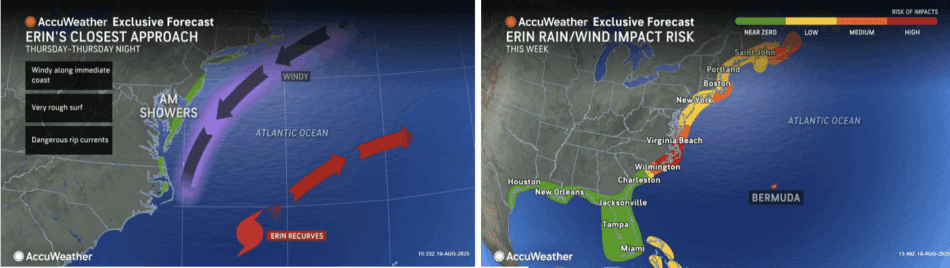
Dangerous rough surf, coastal flooding and life-threatening rip currents are expected along the mid-Atlantic coastline. AccuWeather® hurricane experts say there is a moderate risk to life and property Tuesday through Thursday night.
“The dangers at the beach this week should not be underestimated. Dozens of rip current rescues have already been reported along the Carolinas. The force of the rip currents and rough surf along the Atlantic coast this week is life-threatening,” DaSilva warned. “Hurricane Erin is producing a tremendous amount of energy that will bring hazardous beach conditions from Florida to New England.”
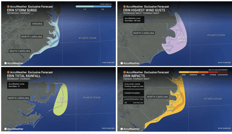
As the storm moves northward between the East Coast and Bermuda, winds may gust up to 40-60 mph along the Outer Banks of North Carolina, with an AccuWeather Local StormMax™ of 80 mph. These winds could cause tree damage, localized power outages, life-threatening rip currents and rough surf.
Hurricane Erin’s wind field is expected to expand significantly, driving waves of 15-20 feet onto the coast of North Carolina and creating life-threatening marine conditions.
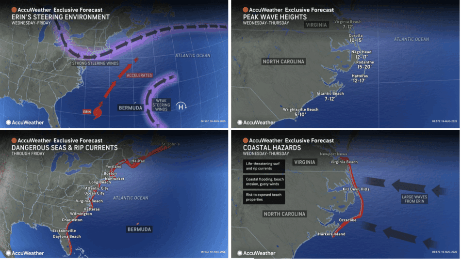
Hurricane Erin may produce storm surge up to 6 feet along the Outer Banks of North Carolina. Surge of up to 3 feet is expected from the northern South Carolina to southern Virginia. This surge may damage or destroy coastal homes and wash out low-lying roadways, such as NC-12, making travel impossible.
“Coastal flooding is expected from northern South Carolina, along much of the North Carolina, and parts of Southern Virginia as Erin moves northeast and parallels the coastline,” DaSilva said.
Impacts expected in Bermuda and Atlantic Canada
AccuWeather® hurricane experts say Erin is forecast to pass west of Bermuda. The storm could bring heavy rain and strong winds to the island, along with dangerous marine and surf conditions, including large swells and strong rip currents.

Rainfall of 1-2 inches is expected in Bermuda, with an AccuWeather Local StormMax™ of 8 inches. Heavy downpours may cause ponding on streets and roadways and flooding in low-lying areas.
Wind gusts of 40-60 mph are expected in Bermuda from Wednesday to Friday, with an AccuWeather Local StormMax™ of 80 mph. These winds may cause tree damage and localized power outages.
As Hurricane Erin passes between the East Coast and Bermuda, the southern shores of Bermuda may experience 1-3 feet of storm surge from Wednesday night through Friday morning.
AccuWeather® hurricane experts report that tropical-storm-force winds are also possible in parts of Nantucket and Cape Cod later this week as Erin moves northeast.
Erin is forecast to pass east of Atlantic Canada late this week into the weekend. The storm could bring rain and gusty winds to parts of Newfoundland and Labrador, along with dangerous marine and surf conditions, including large swells and strong rip currents.

Winds are expected to gust 40-60 mph along portions of Newfoundland, Canada, with an AccuWeather Local StormMax™ of 60 mph. These winds may cause tree damage, localized power outages and life-threatening rip currents and rough surf.
Due to rain, wind and surge, Erin is a less than one on the AccuWeather RealImpact™Scale for Hurricanes in the Caribbean, United States, Bermuda and Canada.