Residents in the Cayman Islands need to keep a very close eye on Melissa

From AccuWeather
The following information is available from AccuWeather Lead Hurricane Expert Alex DaSilva:
“Residents in the Cayman Islands need to keep a very close eye on Melissa as forecast trends over the last 24 hours have been further west in terms of storm track. The potential exists for a tropical storm or hurricane to be near the islands during the early or middle portions of next week. The storm could be moving very slowly at that time and significant rainfall, damaging winds and storm surge could be possible.”
From NHC
| Tropical Storm Melissa |
..AIR FORCE HURRICANE HUNTERS INVESTIGATING MELISSA.. …HEAVY RAINS EXPECTED TO SPREAD TOWARD HISPANIOLA DURING THE NEXT COUPLE OF DAYS
ropical Storm Melissa Discussion Number 1
NWS National Hurricane Center Miami FL AL132025
1100 AM EDT Tue Oct 21 2025
Satellite images, regional Caribbean radar data, and surface
observations indicate that invest 98L has developed a well-defined center and organized deep convection to be designated a tropical cyclone. A ship report that recently passed near the center of the system reported a minimum pressure of about 1003 mb. Satellite imagery shows the system is asymmetric, with the low-level center
near the western edge of the central dense overcast. The initial intensity is set at 45 kt, based on a blend of the latest satellite intensity estimates, marking the formation of Tropical Storm Melissa. An Air Force Hurricane Hunter aircraft is scheduled to investigate the system this afternoon, and their data should provide a better assessment of Melissa's strength and structure.
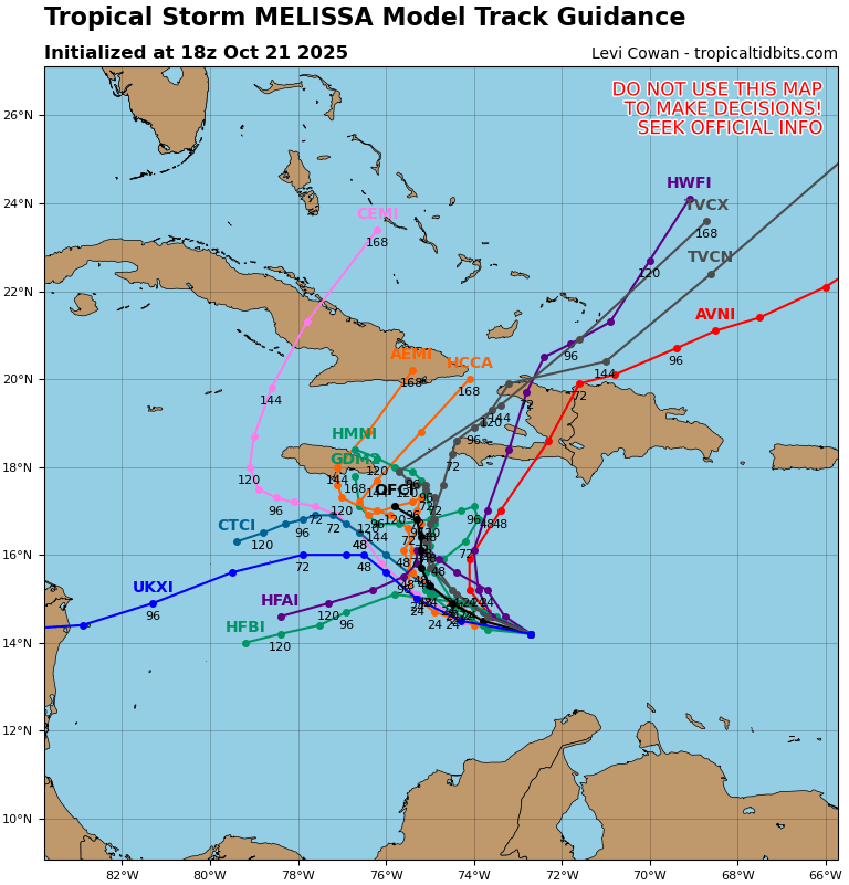
The system was moving very quickly westward over the past several
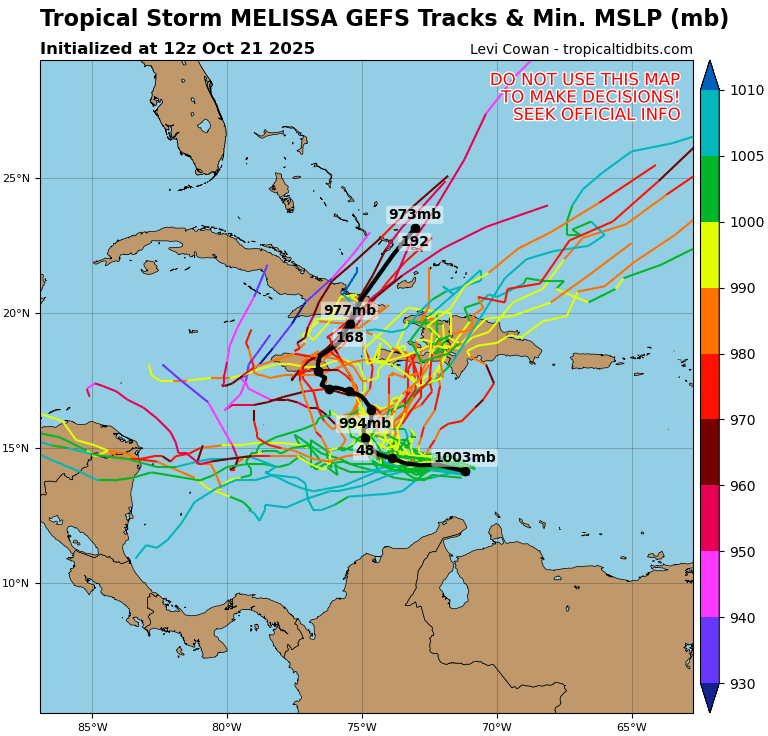
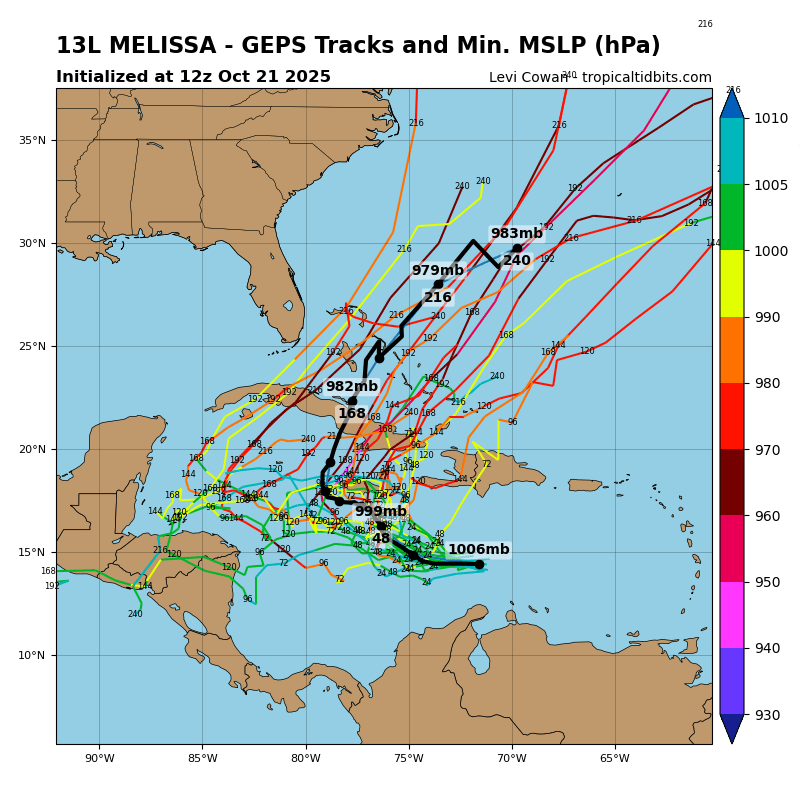
days, but it has slowed down significantly this morning, which has likely helped Melissa form. The initial motion is estimated to be 280/12 kt. Melissa should continue to slow down and gradually turn to the northwest and then north during the next couple of days toward a weakness in the subtropical ridge. This motion will likely take the storm very near the southwestern tip of Haiti and Jamaica by Thursday. After that time, the guidance diverges significantly with some models like the GFS and HWRF showing a motion to the northeast into the weakness, while the other solutions show a stall or a westward drift on the south side of a building ridge. An examination of the GFS, ECMWF, and Google DeepMind ensemble suites suggest that the majority of the members show Melissa not moving into the weakness and remaining in the Caribbean Sea throughout the week and into the weekend. The NHC official track forecast lies between the Google DeepMind ensemble mean track and the correct consensus aid, HCCA.
Melissa is expected to be over the very warm waters of the
Caribbean, but the models suggest that vertical wind shear will be moderate with some dry air in the vicinity of the storm during the next few days. Based on these mixed signals, the strengthening trend is expected to be slow and steady, not rapid. However, the future intensity of Melissa is linked to the track and since that is quite uncertain beyond a couple of days, the strength of the storm is also quite uncertain. The NHC intensity forecast is in best agreement with the HCCA model.
Key Messages:
1. Melissa is expected to bring heavy rainfall and the risk of
significant flash flooding and the danger of landslides to portions of Haiti and the Dominican Republic through the weekend.
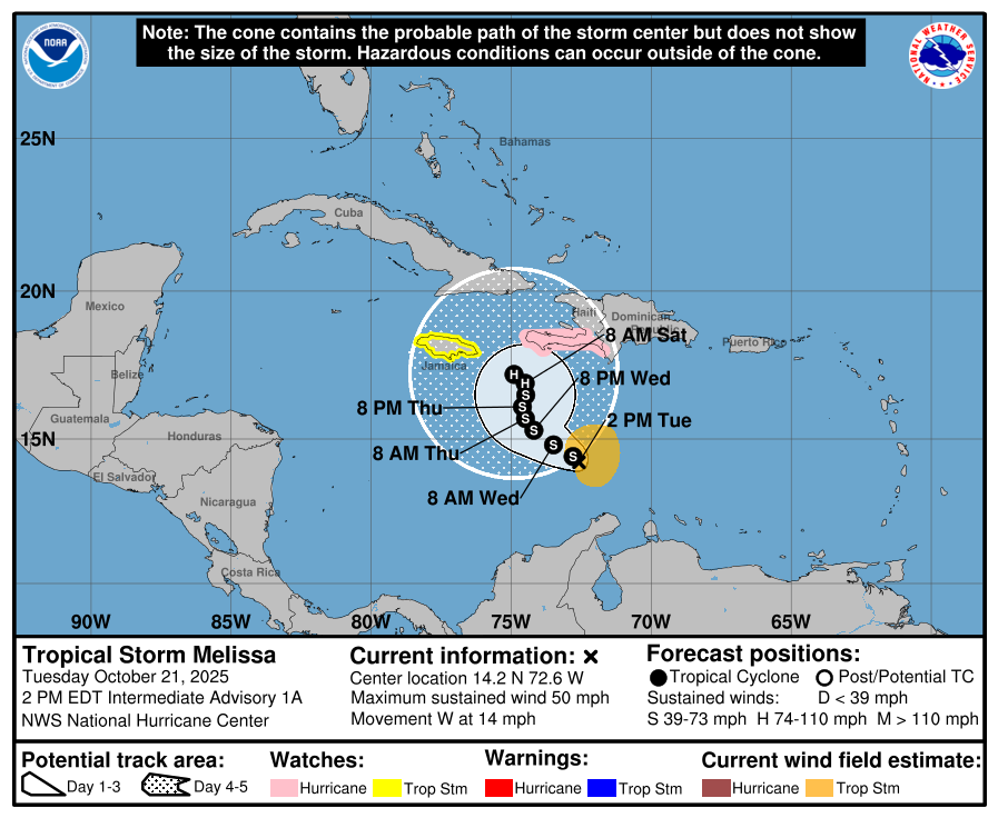
2. A Hurricane Watch has been issued for the southern coast and
Tiburon peninsula of Haiti. A Tropical Storm Watch has been issued for Jamaica. Preparations to protect life and property should be completed by Thursday.
3. There is significant uncertainty in the track and intensity
forecast of Melissa. Interests elsewhere in Hispaniola and Cuba
should continue to monitor the latest forecasts.
FORECAST POSITIONS AND MAX WINDS
INIT 21/1500Z 14.3N 71.7W 45 KT 50 MPH
12H 22/0000Z 14.4N 72.8W 50 KT 60 MPH
24H 22/1200Z 14.8N 73.5W 55 KT 65 MPH
36H 23/0000Z 15.3N 74.2W 60 KT 70 MPH
48H 23/1200Z 15.7N 74.5W 60 KT 70 MPH
60H 24/0000Z 16.1N 74.6W 60 KT 70 MPH
72H 24/1200Z 16.5N 74.5W 60 KT 70 MPH
96H 25/1200Z 16.9N 74.5W 65 KT 75 MPH
120H 26/1200Z 17.2N 74.9W 70 KT 80 MPH
$$
Forecaster Cangialosi/Bucci