New tropical rainstorm develops in the Atlantic; East Coast beach hazards linger into the weekend

> Dangerous rip currents and rough surf will impact East Coast beaches through Saturday as Erin pushes into the open Atlantic
> AccuWeather® hurricane experts say a new tropical rainstorm is forecast to strengthen into a hurricane that will bring rain, wind and storm surge impacts to Bermuda next week
AccuWeather® Global Weather Center – Aug. 22, 2025 – As Hurricane Erin moves away from the East Coast into the open Atlantic, AccuWeather® hurricane experts are tracking a new tropical rainstorm expected to bring direct impacts to Bermuda next week.

“A tropical rainstorm formed Thursday afternoon in the Atlantic. This cluster of showers and thunderstorms is forecast to strengthen to a tropical storm over the weekend as it moves north of the Leeward Islands. People in Bermuda should prepare for wind, rain and storm surge impacts later this weekend into early next week,” AccuWeather® Lead Hurricane Expert Alex DaSilva said. “At this time, direct wind and rain impacts are not expected in the U.S., but rip currents and rough surf could impact some East Coast beaches again next week.”
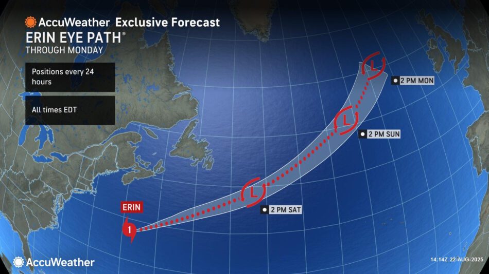
Erin pushes out to sea
Hurricane Erin will continue to move northeast across the northern Atlantic through the weekend.
Life-threatening rough surf and rip currents will persist along the East Coast of the United States through Saturday. Coastal flooding is expected from central North Carolina northward into southern New England.
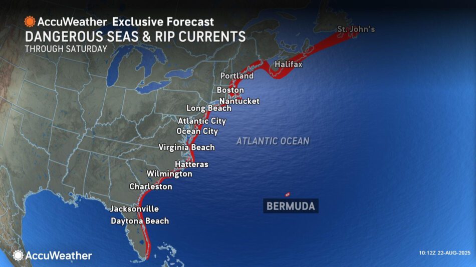
“Rough surf and rip currents will linger along beaches across the East Coast through Saturday as Erin pushes out to sea. Everyone heading to the beach this weekend should pay attention to the warning flags and stay in areas where lifeguards are on duty,” DaSilva said. “The weather may seem like a perfect beach day under a blue sky, but rip currents lurking underwater will be powerful and dangerous.”
New tropical rainstorm forms in the Atlantic
AccuWeather® hurricane experts are tracking a new tropical rainstorm that has formed northeast of the Lesser Antilles. It is expected to strengthen into a hurricane as it tracks north-northwestward across the Atlantic.

AccuWeather® uses the term “tropical rainstorm” to describe certain tropical systems that may bring significant impacts from rain or wind before they are officially classified as a tropical depression or storm in order to raise public awareness of their disruptive, damaging and dangerous potential.
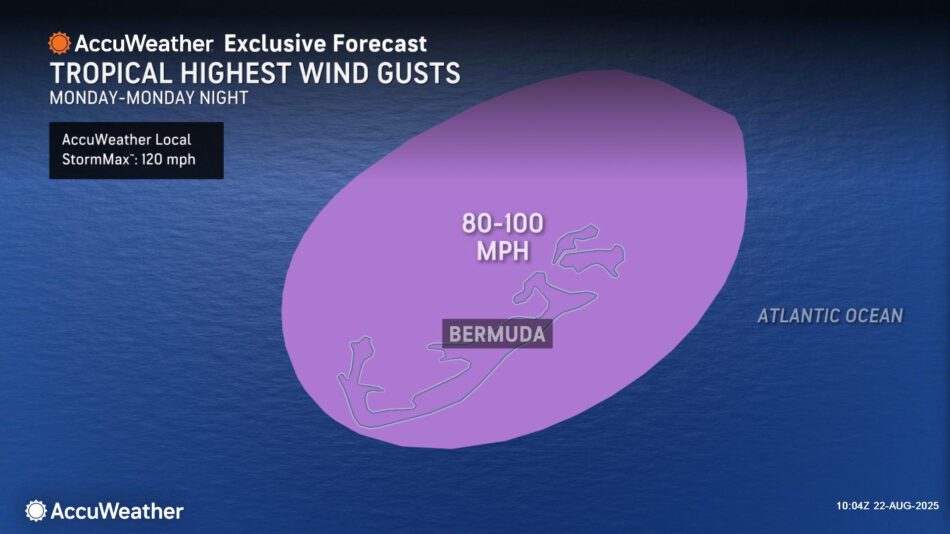
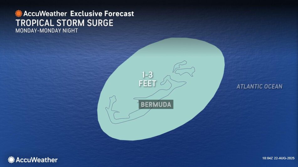
“This storm is expected to bring several inches of rain, wind gusts of 80-100 mph and several feet of storm surge to Bermuda,” DaSilva said.
This tropical rainstorm is expected to track to the northwest before quickly turning northward in the western Atlantic while gaining wind intensity, becoming a tropical storm Saturday.
The next name on the 2025 Atlantic Hurricane list is Fernand. As the storm continues to gain wind intensity this weekend and move north, it is expected to become a Category 1 hurricane and pass very close to Bermuda Monday.
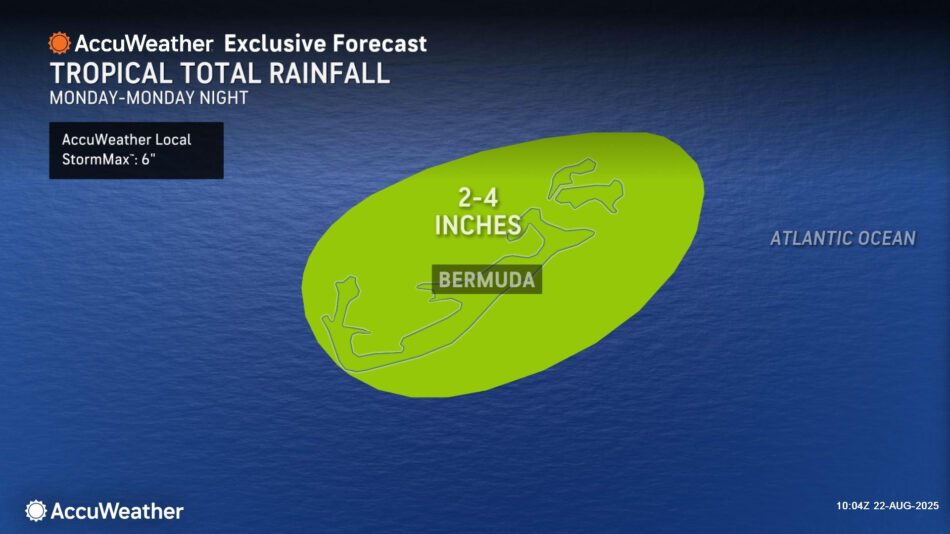
AccuWeather® hurricane experts forecast 2-4 inches of rain in Bermuda, with an AccuWeather Local StormMax™ of 6 inches.
Strong wind gusts of 80-100 mph are expected in Bermuda Monday, with an AccuWeather Local StormMax™ of 120 mph. These winds can down trees,cause minor damage to houses and lead to sporadic power outages.
A dangerous storm surge of 1-3 feet could impact beaches across Bermuda.
Impacts will also be possible in portions of Atlantic Canada next week, as the storm passes just offshore of Newfoundland, bringing rain and wind.
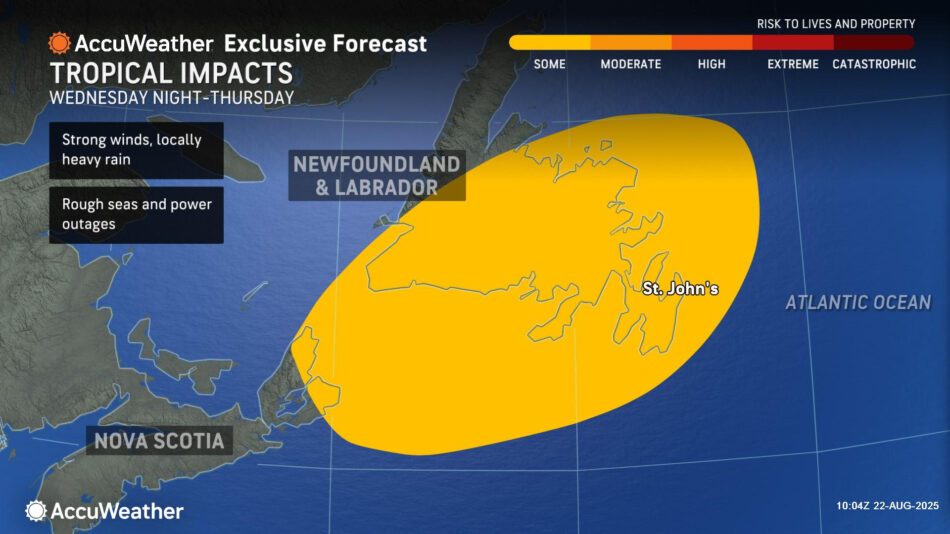
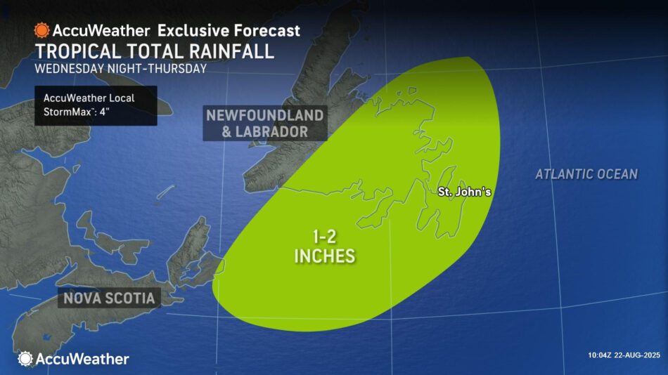
The storm will bring a broad area of 40- to 60-mph wind gusts to eastern Nova Scotia and much of Newfoundland, as well as an area of 60- to 80-mph gusts in southeastern Newfoundland, including St. John’s. An AccuWeather Local StormMax™ of 90 mph is also possible. These strong winds can also down trees, cause property damage and lead to power outages.
Additional tropical hazards on the horizon
AccuWeather® hurricane experts are tracking a high-risk area for tropical development in the eastern and central Atlantic from Aug. 23-25.
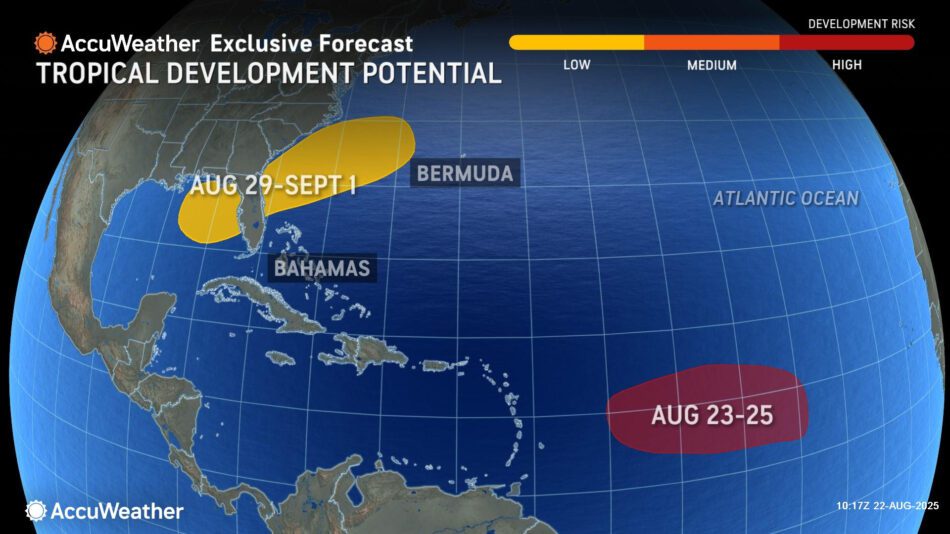
“A tropical wave moving through the Atlantic main development region has a limited window for development over the next few days before it encounters dry air and hostile atmospheric conditions,” DaSilva explained. “This tropical wave will be monitored closely late this weekend into early next week as it moves over exceptionally warm waters.”
AccuWeather® hurricane experts are also monitoring a low-risk area for tropical development in the northeastern Gulf and along the Southeast coast from Aug. 29-Sept. 1.
“A slow-moving cold front could spin up homegrown tropical development near the coast around the end of the month into early September. Hurricane Erin left behind a trail of cooler water in its wake, but the water temperatures will rebound over the next week or two. It will be warm enough to support tropical development,” DaSilva said.
AccuWeather® uses the term “homegrown tropical development” to describe tropical storms and hurricanes that develop close to the U.S. coast, often in the Gulf or the southwestern Atlantic.
“Waters in the Gulf and Caribbean are exceptionally warm right now, and temperatures are expected to continue rising in the coming weeks. Conditions are primed for rapid intensification if a storm develops or moves into the Gulf or Caribbean,” DaSilva said. “The heart of hurricane season is starting to heat up. Atmospheric conditions in the Atlantic are forecast to become more conducive for tropical development heading into the first and second weeks of September. The climatological peak of the Atlantic hurricane season is Sept. 10. We expect the second half of the hurricane season to be more active than the first half.”
AccuWeather® hurricane experts predicted three to five named storms will develop in the Atlantic basin during August.
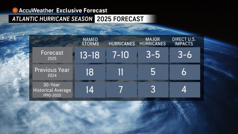
The AccuWeather® 2025 Atlantic Hurricane Season Forecast predicts 13 to 18 named storms, including seven to 10 hurricanes. Of these, three to five could be major hurricanes of Category 3 strength or higher on the Saffir-Simpson Hurricane Wind Scale. A Category 3 hurricane has sustained winds of 111-129 mph.
AccuWeather® is forecasting three to six direct impacts to the U.S. this year, which is the same range AccuWeather® predicted for the historic 2024 Atlantic hurricane season. AccuWeather® was the first known source to issue an Atlantic hurricane season forecast in March.
In a May update, AccuWeather® hurricane experts urged people, businesses, officials and emergency responders to prepare for an increased risk of flooding and tornado impacts reaching far inland after landfall, similar to last year.
Additional AccuWeather® Resources:
US Atlantic Coast to face lingering surf hazards as Hurricane Erin departs
Tropical rainstorm develops in Atlantic following Hurricane Erin
Hurricane Erin, far offshore, unleashes coastal flooding in the Northeast
How to avoid the potentially deadly grip of a rip current
The dangers of rip currents
Rip currents account for over 80% of beach rescues, but what are they and how can you stay safe?
Flooding and tornado impacts could reach far inland again this Atlantic hurricane season
AccuWeather® forecasting 3-6 direct storm impacts to the U.S. during the 2025 Atlantic Hurricane season
AccuWeather RealImpact™ Scale for Hurricanes
AccuWeather® Hurricane Tracker