Major flooding risk from newly formed Tropical Rainstorm in the Caribbean
From AccuWeather
AccuWeather is the first known source to issue a storm track for a tropical rainstorm that is expected to move westward over the next few days while gradually gaining wind intensity
> A tropical storm is expected to develop over the next day or two. The next name on the list of Atlantic basin storms is Melissa
> Torrential rainfall could trigger life-threatening flooding and mudslides in Haiti, Dominican Republic, and Cuba starting later this week
AccuWeather® Global Weather Center – Oct. 21, 2025 – Catastrophic and life-threatening flooding is possible starting later this week, as a Tropical Rainstorm has now formed in the western Caribbean. AccuWeather is the first known source to issue a forecast track for the brewing tropical storm that is expected to strengthen into a hurricane in the Caribbean later this week.

AccuWeather uses the term “tropical rainstorm” to describe certain tropical systems that may bring significant impacts from rain or wind before they are officially classified as a tropical depression or storm in order to raise public awareness of their disruptive, damaging and dangerous potential.
“AccuWeather hurricane experts are increasingly concerned about the potential for a life-threatening, catastrophic flooding disaster across parts of the Caribbean, especially near steep terrain across parts of Cuba, Haiti and the Dominican Republic should the storm move north and slow down considerably,” AccuWeather Chief Meteorologist Jonathan Porter said.
- AccuWeather hurricane experts say a tropical rainstorm formed Monday night in the eastern Caribbean, just west of the Lesser Antilles.
- This tropical rainstorm is expected to gradually gain wind intensity as it moves westward over the next few days. Due to conditions conducive for strengthening, the storm is expected to intensify into a hurricane as it slows down and begins to turn to the north later this week.
- The next name on the list of Atlantic basin storms is Melissa.
- It is also possible that this rainstorm could undergo rapid intensification as it sits over the warm waters of the Caribbean.
- As the storm moves northward, significant flooding and strong winds will be possible in Jamaica, Cuba, and Hispaniola.
- There is also the possibility the storm drifts farther west before making a northward turn. People in the Caribbean and Mexico should continue to monitor the progress of this storm, as a shift in track can bring impacts farther west.
“Mountains add an extra lifting mechanism to enhance rainfall rates, which can fall at 4 inches or more per hour in tropical rainbands,” Porter said. “The rain may come too fast, too furious and in areas of steep terrain, runoff is greatly enhanced, further increasing the risk for catastrophic flooding and mudslides, damaging buildings and roads, with the potential for bridges, roadways, railroads and other infrastructure to be washed out or destroyed.”
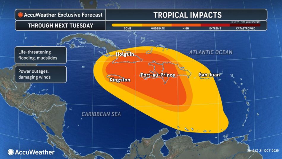
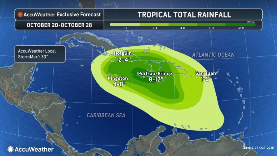
- Widespread rainfall amounts of 4-8 will occur from Jamaica to the Dominican Republic. Rainfall amounts of 8-16 inches can occur in Haiti, eastern Cuba, eastern Jamaica and western portions of the Dominican Republic, with an AccuWeather Local StormMax™ of 30 inches.
- This heavy rain can lead to widespread, life-threatening flash flooding and mudslides, especially across the varied terrain of the islands.
- Rainfall amounts will be highly dependent on the track of the storm, as a westward shift in the track can lead to higher rainfall amounts. Should the storm stall near the coast of one or more of the Greater Antilles, there could be a historic flooding disaster in that region due to repeated rounds of torrential tropical downpours.
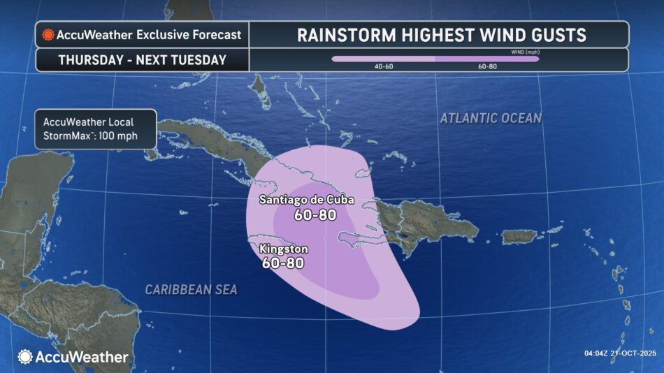

The strong winds can bring down trees and power lines and can cause some structural damage. Power outages can last for days where the strongest winds occur.
END
We have sent out a call to AccuWeather to see if we also should prepare
REPLY
The following information is available from AccuWeather Lead Hurricane Expert Alex DaSilva:
“Residents in the Cayman Islands need to keep a very close eye on Melissa as forecast trends over the last 24 hours have been further west in terms of storm track. The potential exists for a tropical storm or hurricane to be near the islands during the early or middle portions of next week. The storm could be moving very slowly at that time and significant rainfall, damaging winds and storm surge could be possible.”
Links for updates: