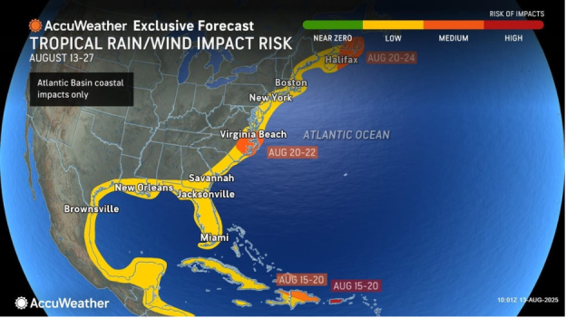
Increasing risk of coastal hazards in the mid-Atlantic and Puerto Rico as Erin intensifies
From AccuWeather

AccuWeather® hurricane experts expand the risk zone for storm surge, flooding rainfall and mudslides in the Caribbean
Elevated risk of beach erosion and strong rip currents next week across the Outer Banks of North Carolina and southeastern Virginia
AccuWeather® hurricane experts have issued a medium risk of tropical development potential in the Gulf through Friday
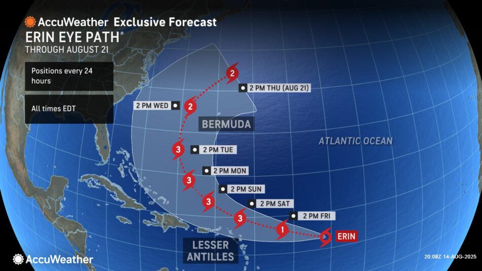
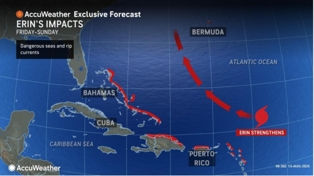
AccuWeather® Global Weather Center – Aug. 14, 2025 – Tropical Storm Erin is forecast to intensify into a hurricane over the next 24 hours before bringing wind, rain and storm surge impacts to parts of the Caribbean this weekend and Bermuda next week.
AccuWeather® Lead Hurricane Expert Alex DaSilva says the risk of direct impacts reaching parts of the mid-Atlantic coast next week is increasing.
“AccuWeather® expert meteorologists expect Erin to curve north and move out to sea. If the storm advances farther west, the likelihood of direct rain and wind impacts to the Outer Banks will increase,” DaSilva said. “Beach erosion and dangerous rip currents are a growing concern along the Outer Banks.”
Impacts expected in the Caribbean and Bermuda
Conditions northeast of the Lesser Antilles will favor additional strengthening and may support rapid intensification. Erin is expected to become a major hurricane this weekend.

“Erin is moving into an area of the Atlantic primed for rapid intensification. The waters are incredibly warm. There’s little disruptive wind shear, dry air or dust to slow this storm down,” DaSilva explained. “Erin is forecast to strengthen into a Category 1 hurricane on Friday and then rapidly intensify into a Category 3 hurricane by Saturday afternoon. There is a window of opportunity where Erin could explode into a Category 4 hurricane in the Atlantic.”


Locally heavy rain is expected from the northern Leeward Islands through Puerto Rico and the Turks and Caicos this weekend into early next week. General rain amounts will total 1-2 inches across the Turks and Caicos Islands and the northern portions of the Dominican Republic. Higher amounts of 2-4 inches are possible across Puerto Rico and the northern Leeward Islands, with an AccuWeather Local StormMax™ of 7 inches. This rainfall can lead to flash flooding and localized mudslides in the higher terrain.
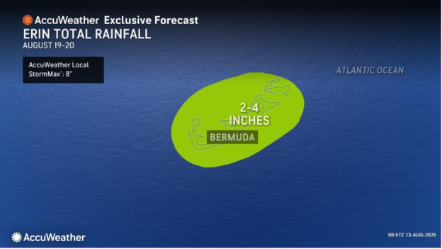
Heavy rain may also impact Bermuda next week as Erin progresses northward. General rainfall totals are expected to reach 2-4 inches, with an AccuWeather Local StormMax™ of 8 inches.
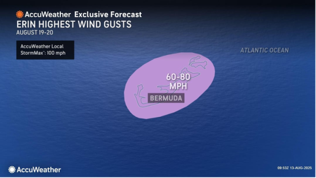
Erin may bring wind gusts of 40-60 mph, with an AccuWeather Local StormMax™ of 80 mph, from the northern Leeward Islands to the Turks and Caicos Islands this weekend into early next week. As Erin tracks northward next week and passes west of Bermuda, wind gusts are forecast to reach 60–80 mph, with an AccuWeather Local StormMax™ of 100 mph. These winds may cause tree and power line damage, leading to localized power outages.
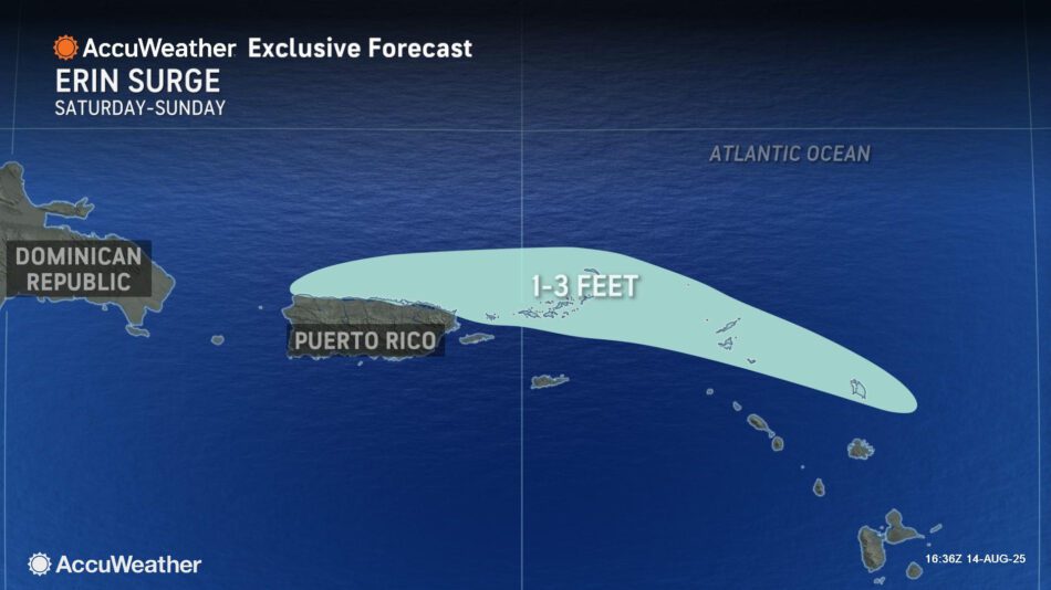
Localized flooding due to heavy rainfall and gusty winds is expected from Saint Martin through the northern half of Puerto Rico this weekend. Dangerous seas and rip currents are also expected.
AccuWeather® hurricane experts forecast 1-3 feet of storm surge from parts of the northern Leeward Islands of Antigua and Barbuda through the northern coast of Puerto Rico.
Due to expected impacts from rain, wind and storm surge, Erin currently rates as less than one on the AccuWeather RealImpact™ Scale for Hurricanes in the Caribbean.
A rating of less than one on the AccuWeather RealImpact™ Scale for Hurricanes indicates limited damage potential from wind and rain, as well as some coastal inundation capable of causing property damage.
Erin is forecast to track near Bermuda next week as it moves northward. Rainfall amounts are expected to reach 2-4 inches, with an AccuWeather Local StormMax™ of 8 inches.
Wind gusts of 60-80 mph are likely in Bermuda, with an AccuWeather Local StormMax™ of 100 mph. These winds may cause tree and power line damage, leading to localized power outages.
“People need to be prepared as we head into the heart of hurricane season,” DaSilva said. “An eastward shift in the track could bring Category 3 hurricane conditions to Bermuda next week.”
Increasing risk of hazardous impacts reaching the East Coast
AccuWeather® hurricane experts are urging people and businesses along the East Coast to closely monitor AccuWeather® forecast updates throughout the weekend as Erin continues to strengthen.
Rough surf and dangerous rip currents are likely at times next week from Florida to New England.
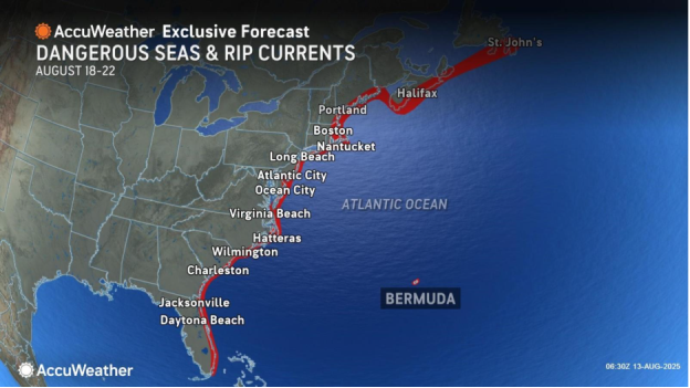
“Be vigilant if you’re going to an East Coast beach next week. Make sure you know the warning signs of rip currents and learn how to escape one by swimming parallel to the shore. Pay attention to the beach warning flags and only swim in areas with lifeguards on duty,” DaSilva said. “Do not underestimate the power of a major hurricane far off the East Coast. These massive storms produce very rough surf and lethal rip currents that can impact beaches hundreds of miles away.”
DaSilva says the risk of direct wind and rain impacts, as well as coastal erosion, reaching the Outer Banks next week is increasing.
“The current forecast track keeps Erin offshore, but the East Coast is not in the clear. A westward shift in the track could bring rain and wind impacts to eastern North Carolina, Long Island, and southeastern New England,” DaSilva said.
Eye on the Gulf
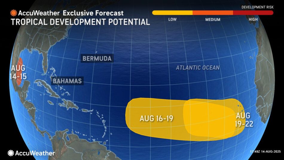
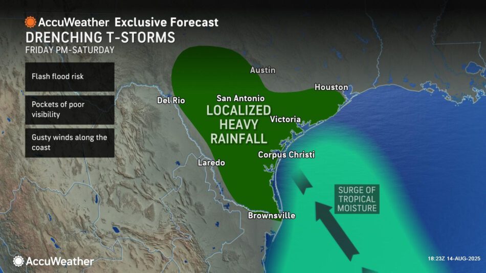
AccuWeather® hurricane experts have issued a medium risk of tropical development through Friday over the southwestern Gulf as a tropical wave moves across the Bay of Campeche today.
Regardless of tropical development, increased thunderstorm activity Friday and Saturday could bring a localized flash flooding risk to central and South Texas, includi
ng parts of the Texas Hill Country.
AccuWeather® hurricane experts are forecasting a low risk for tropical development across the eastern and central Atlantic from Aug. 16-19. As this feature moves westward across the Atlantic, it will need to be monitored for potential impacts on the Caribbean.
Additionally, forecasters are tracking another low risk area for tropical development in the eastern and central Atlantic from Aug. 19-22.
The AccuWeather® 2025 Atlantic Hurricane Season Forecast predicts 13 to 18 named storms, including seven to 10 hurricanes and three to five major hurricanes that reach Category 3 strength or higher on the Saffir-Simpson Hurricane Wind Scale. A Category 3 hurricane has sustained winds between 111 and 129 miles per hour.
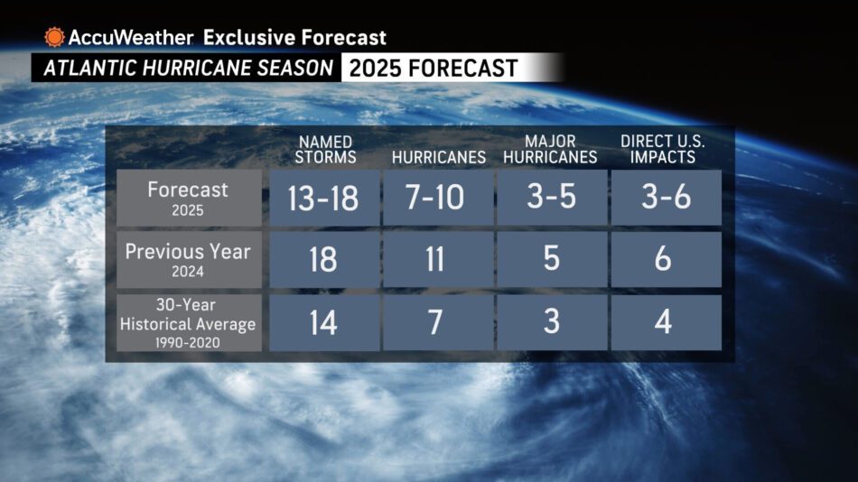
AccuWeather® is forecasting three to six direct impacts to the U.S. this year, which is the same range AccuWeather® forecast for the historic 2024 Atlantic hurricane season.
AccuWeather® was the first known source to issue an Atlantic hurricane season forecast in March.
AccuWeather® hurricane experts issued an update in May, urging people, businesses, officials and emergency responders to prepare for an increased risk of flooding and tornado impacts reaching far inland after landfall, similar to last year.
Additional AccuWeather® Resources:
Strengthening Erin to fuel dangerous surf, coastal flood risk from Carolinas to New England
Erin to track near Leeward Islands, Puerto Rico as a rapidly strengthening hurricane
Bermuda’s resiliency to hurricanes dates back 300 years
Historic hurricane landfalls in Bermuda
The last time we had a Hurricane Erin, it was on 9/11
How to avoid the potentially deadly grip of a rip current
Rip currents account for over 80% of beach rescues, but what are they and how can you stay safe?
‘Hurricane drought’ in the Northeast; is the region prepared?
Flooding and tornado impacts could reach far inland again this Atlantic hurricane season
AccuWeather® forecasting 3-6 direct storm impacts to the U.S. during the 2025 Atlantic Hurricane season
AccuWeather RealImpact™ Scale for Hurricanes
AccuWeather® Hurricane Tracker