Erin to soak parts of Puerto Rico before sending rough surf and dangerous rip currents to the U.S. East Coast
From AccuWeather

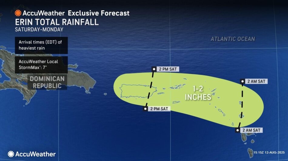
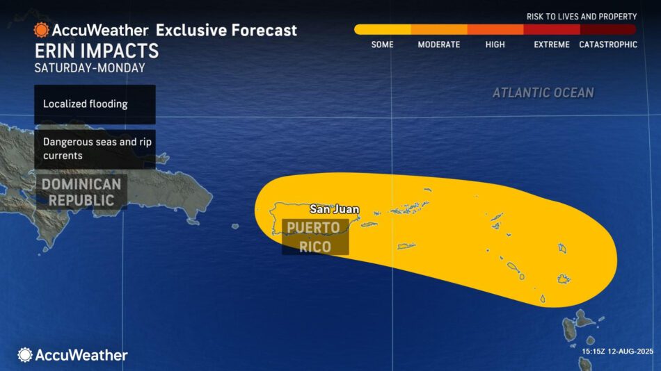
AccuWeather® forecasts Erin to impact parts of Puerto Rico this weekend with 1-2 inches of rainfall and 40- to 60-mph wind gusts
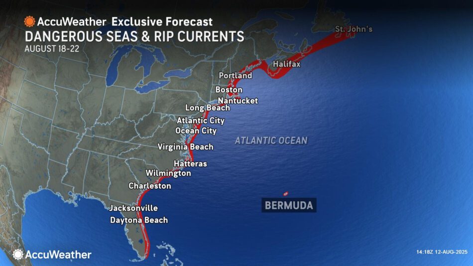
The storm will produce rough surf and rip currents that will likely impact Bermuda, the Bahamas, and along much of the U.S. East Coast
AccuWeather® Global Weather Center – Aug. 12, 2025 – AccuWeather® hurricane experts say Tropical Storm Erin is expected to strengthen into a major hurricane this weekend, bringing rain and wind impacts to parts of Puerto Rico.
“People and businesses in the northeast Caribbean should be on high alert. Erin will bring gusty winds and heavy rain to Puerto Rico as it passes to the north this weekend. A widespread 1 to 2 inches of rain is expected across Puerto Rico and the U.S. Virgin Islands. Some spots may see up to seven inches of rain, which could trigger flash flooding,” AccuWeather® Lead Hurricane Expert Alex DaSilva said. “Wind gusts of 40 to 60 mph are likely across the northern end of Puerto Rico. Some gusts could approach 80 mph. Gusty winds from Erin may trigger power outages.”
AccuWeather® hurricane experts are sounding the alarm about the growing risk of dangerous beach conditions across the Bahamas, Bermuda and much of the East Coast of the United States.
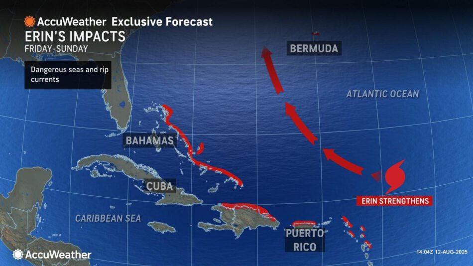
“Erin will churn up rough surf and dangerous rip currents along the Atlantic coastline from Florida all the way north to Maine starting this weekend into next week. Beach erosion is possible in some areas,” DaSilva warned. “A major hurricane in the open Atlantic can produce very rough surf that will impact beaches hundreds of miles away. Hazardous beach conditions are likely across parts of the Caribbean, Bahamas and Bermuda.”
Officials say more than 50 people across the United States and Puerto Rico have died in surf zones this year due to rip currents, high surf, or sneaker waves.
Impacts in the Caribbean
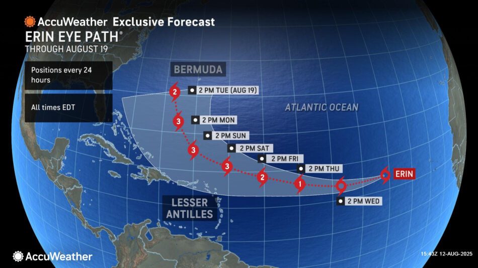
Tropical Storm Erin is expected to continue to strengthen and eventually become a hurricane while crossing the Atlantic later this week.
Environmental conditions northeast of the Lesser Antilles will be very conducive for intensification, and potentially rapid intensification. Erin is expected to intensify into a major hurricane this weekend.
Locally heavy rain will fall from Saint Martin through Puerto Rico from Saturday through Monday. General rain amounts will total 1-2 inches, with an AccuWeather Local StormMax™ of 7 inches.
Wind gusts of 40-60 mph with an AccuWeather Local StormMax™ of 80 mph are expected from Saint Martin through the northern portion of Puerto Rico Saturday through Monday.
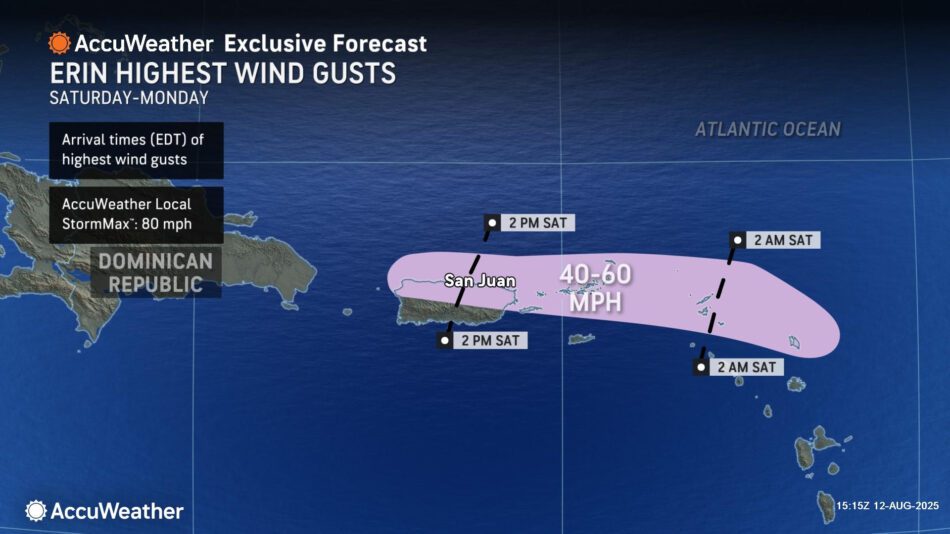
Localized flooding due to heavy rain and gusty winds are expected from Saint Martin through the northern half of Puerto Rico this weekend due to Erin. Dangerous seas and rip currents are also expected.
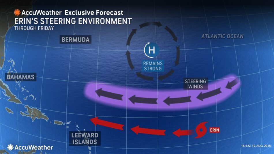
What will steer Erin?
People and businesses in the Bahamas, Bermuda, and along the East Coast of the United States should monitor Erin’s progress, as a shift in the track could directly impact these areas.
“The strength and positioning of the Bermuda High, a dip in the jet stream over the U.S., and a cold front pushing off the East Coast are expected to be the pivotal factors that will steer Erin over the weekend into next week,” DaSilva said.
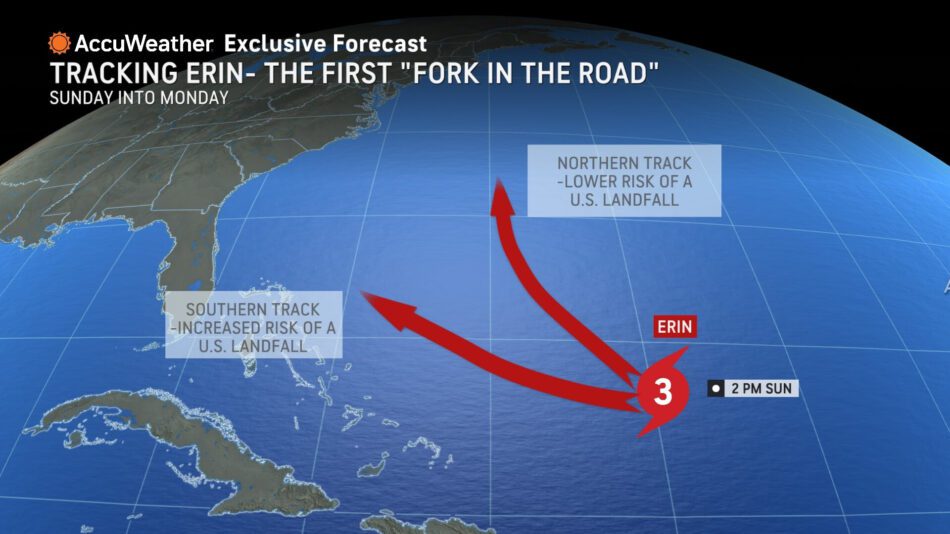
AccuWeather® hurricane experts say there are two likely scenarios that will steer Erin this weekend into next week once the storm reaches a “fork in the road”.
A faster-moving dip in the jet stream will guide Erin away from the U.S. East Coast, while a slower-moving dip in the jet stream could allow Erin to track closer to the coastline.
AccuWeather® hurricane experts say Erin will churn up rough surf and dangerous rip currents along much of the Atlantic coastline from Florida to New England and Atlantic Canada next week.
“At this time, Erin is forecast to curve north and track parallel to the U.S. East Coast hundreds of miles offshore. Many factors can change during that time. Everyone along the East Coast should closely monitor forecast updates this week,” DaSilva explained. “At this point in the hurricane season, everyone needs to be prepared. Make sure your emergency supplies are stocked up, review your safety plans and evacuation routes, and check your insurance coverage. The climatological peak of hurricane season is just four weeks away.”
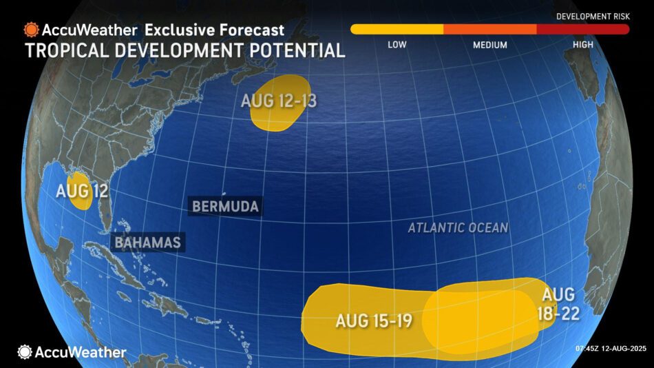
AccuWeather® hurricane experts are also monitoring four additional areas at low risk of tropical development potential in the Atlantic basin.
AccuWeather® hurricane experts say there is a high risk of tropical rain and wind impacts in Puerto Rico and the northern Leeward Islands starting Friday through Tuesday.
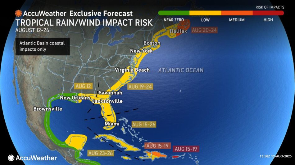
A medium risk of tropical rain and wind impacts extends across northern Hispaniola, the Lesser Antilles and eastern Bahamas from Aug. 15-19 as Erin passes near the area.
A medium risk of tropical rain and wind impacts from Erin is also forecast for eastern Nova Scotia from Aug. 20-24.
A low risk of tropical rain and wind impacts has been expanded from the central and eastern Gulf Coast, across Florida, and along the entire East Coast.
AccuWeather® hurricane experts are forecasting a low risk of tropical development on Aug. 12 over the Gulf. There can be localized flash flooding along the northern Gulf Coast through Tuesday night associated with this area.
Additional AccuWeather® Resources:
Caribbean, Bahamas on alert as Erin set to strengthen into hurricane
The last time we had a Hurricane Erin, it was on 9/11
How to avoid the potentially deadly grip of a rip current
Rip currents account for over 80% of beach rescues, but what are they and how can you stay safe?
‘Hurricane drought’ in the Northeast; is the region prepared?
Flooding and tornado impacts could reach far inland again this Atlantic hurricane season
AccuWeather® forecasting 3-6 direct storm impacts to the U.S. during the 2025 Atlantic Hurricane season
AccuWeather RealImpact™ Scale for Hurricanes
AccuWeather® Hurricane Tracker