15 Nov Weather in Cayman & Tropical Report, 1 H.C, 1 TD
Sun 15 Nov 2020
TROPICAL REPORT
ATLANTIC Tropical Weather Outlook
Atlantic – Caribbean Sea – Gulf of Mexico
Tropical Weather Outlook (en Español*)
700 AM EDT Sun Nov 15 2020
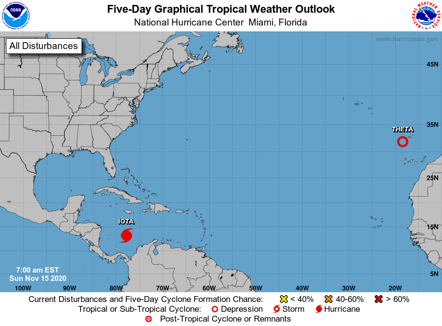
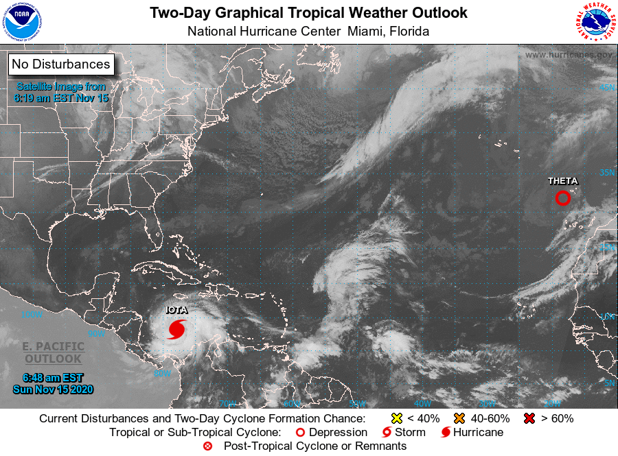
Tropical Weather Outlook
NWS National Hurricane Center Miami FL
700 AM EST Sun Nov 15 2020

For the North Atlantic...Caribbean Sea and the Gulf of Mexico:

The National Hurricane Center is issuing advisories on Tropical Depression Theta, located over the far northeastern Atlantic, and on Hurricane Iota, located over the southwestern Caribbean Sea.

Tropical cyclone formation is not expected during the next 5 days.

$$
Forecaster Brown
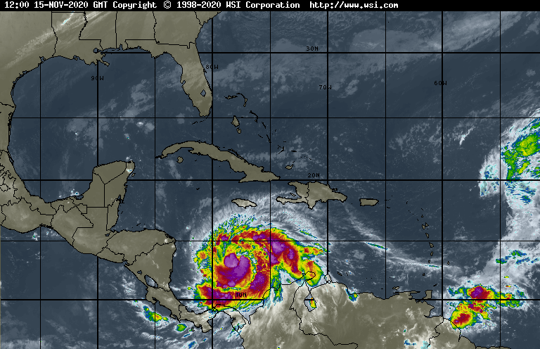
H.C. IOTA CONTINUES TO RAPIDLY STRENGTHEN… …EXPECTED TO BRING POTENTIALLY CATASTROPHIC WINDS, A LIFE-THREATENING STORM SURGE, AND RAINFALL IMPACTS TO CENTRAL AMERICA

TD THETA EXPECTED TO BECOME POST-TROPICAL LATER TODAY
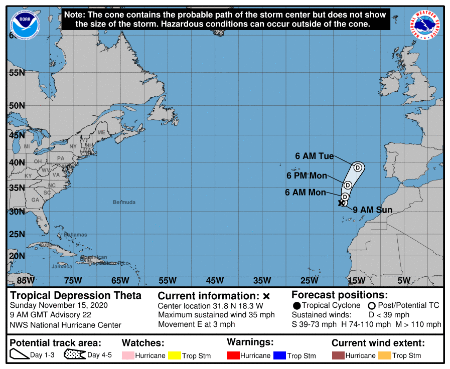
Tropical Depression Theta Discussion Number  22
NWS National Hurricane Center Miami FL       AL302020
900 AM GMT Sun Nov 15 2020

Theta is barely a tropical cyclone. The only remnants of deepconvection are a small area of warming cloud tops, located around 90 n mi to the southeast of Theta's exposed center. The cyclone has produced little central convection all day, so it is assumed that at least slight weakening has occurred and the intensity is set at 30 kt. This also agrees with a blend of the latest Dvorak Final-T and CI numbers from TAFB. If Theta does not redevelop substantial
inner-core convection soon, it will likely become a remnant low later today.

The cyclone has slowed down and is moving eastward with an initial motion of 090/4 kt. A continued slow eastward track is expected today, before a ridge centered over northwestern Africa begins to steer the cyclone northward on Monday. Although Theta could continue to produce intermittent bursts of convection, no significant redevelopment is anticipated due to surrounding dry air and cool underlying SSTs. The cyclone is forecast to become a remnant low
within 12 h and dissipate in 60 h. No major changes were made to the NHC track or intensity forecasts, both of which are based on the multi-model consensus aids.


FORECAST POSITIONS AND MAX WINDS

INIT  15/0900Z 31.8N  18.3W   30 KT  35 MPH
 12H  15/1800Z 31.9N  17.8W   30 KT  35 MPH...POST-TROP/REMNT LOW
 24H  16/0600Z 33.1N  17.5W   25 KT  30 MPH...POST-TROP/REMNT LOW
 36H  16/1800Z 35.5N  16.9W   25 KT  30 MPH...POST-TROP/REMNT LOW
 48H  17/0600Z 39.0N  14.8W   20 KT  25 MPH...POST-TROP/REMNT LOW
 60H  17/1800Z...DISSIPATED

$$
Forecaster Zelinsky
Eastern North Pacific (East of 140°W)
Tropical Weather Outlook (en Español*)
400 AM EDT Sun Nov 15 2020
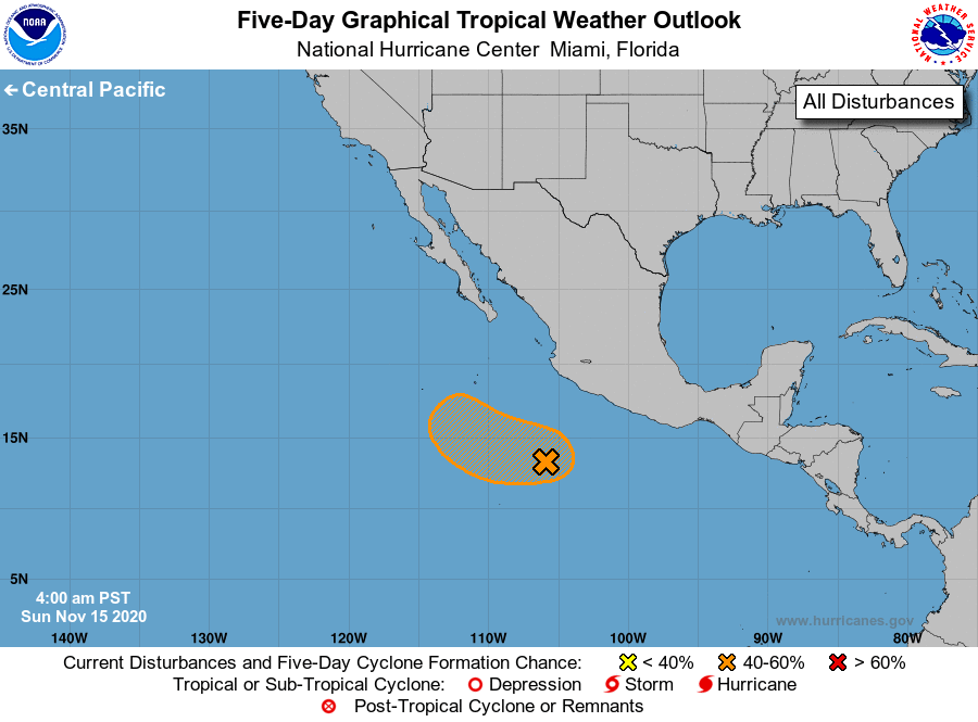
Tropical Weather Outlook
NWS National Hurricane Center Miami FL
400 AM PST Sun Nov 15 2020

For the eastern North Pacific...east of 140 degrees west longitude:

1. Shower and thunderstorm activity associated with a broad area of low pressure located several hundred miles southwest of the coast of southern Mexico has increased somewhat overnight. Although environmental conditions are only marginally favorable, some slow  development of this system is possible, and a tropical depression could form within a few days as the system moves slowly west-northwestward or northwestward away from the coast of Mexico. By mid week, conditions are expected to become unfavorable for further development.
* Formation chance through 48 hours...low...30 percent.
* Formation chance through 5 days...medium...40 percent.

Forecaster Blake/Brown
Weather in Cayman
SYNOPSIS
Fresh winds and rough seas will continue across the Cayman area as Hurricane Iota strengthens south of Jamaica and is expected to continue to move towards the west
Humidity: 86% (UP from yesterday)
UV: 7.2 HIGH (DOWN from yesterday)
Temperature: Today’s expected temperatures – 77 to 91°F. Yesterday: H 91.2°F L 76.8°F
Winds: ENE 15-25 mph Tonight: ENE 10-20 mph
Barometer: 1011.50 mb Rising slowly
Rain: Last month: 10.80 in
Last 24 hrs (since yesterday’s reading) 0.13in
This month: 13.72 in
0 days since rain, 9 rain days in Nov
2019 Season Total: 31.27 in
2020 Season Total: 77.52 in
Latest rainfall readings are from NORTH SOUND.
Average rainfall in Nov 4.6 in.
Average temperature in Nov: 75°F to 86°F
Sea Temperature in Nov: 82°F
MOON: 0% illumination

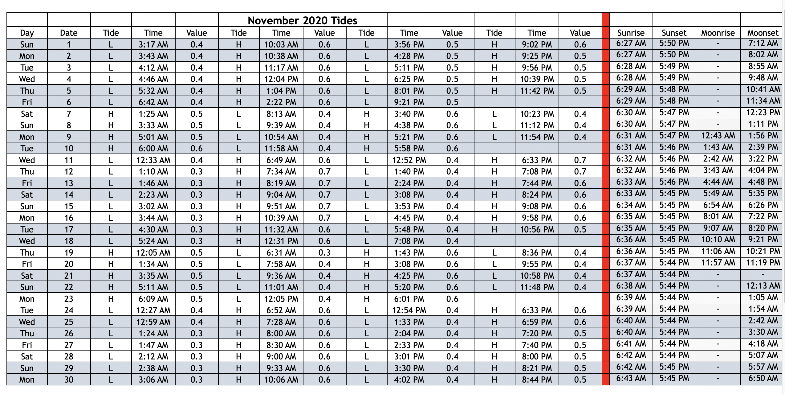
Tides, Moonrise, Moonset, and Moon Phases, NOV 2020
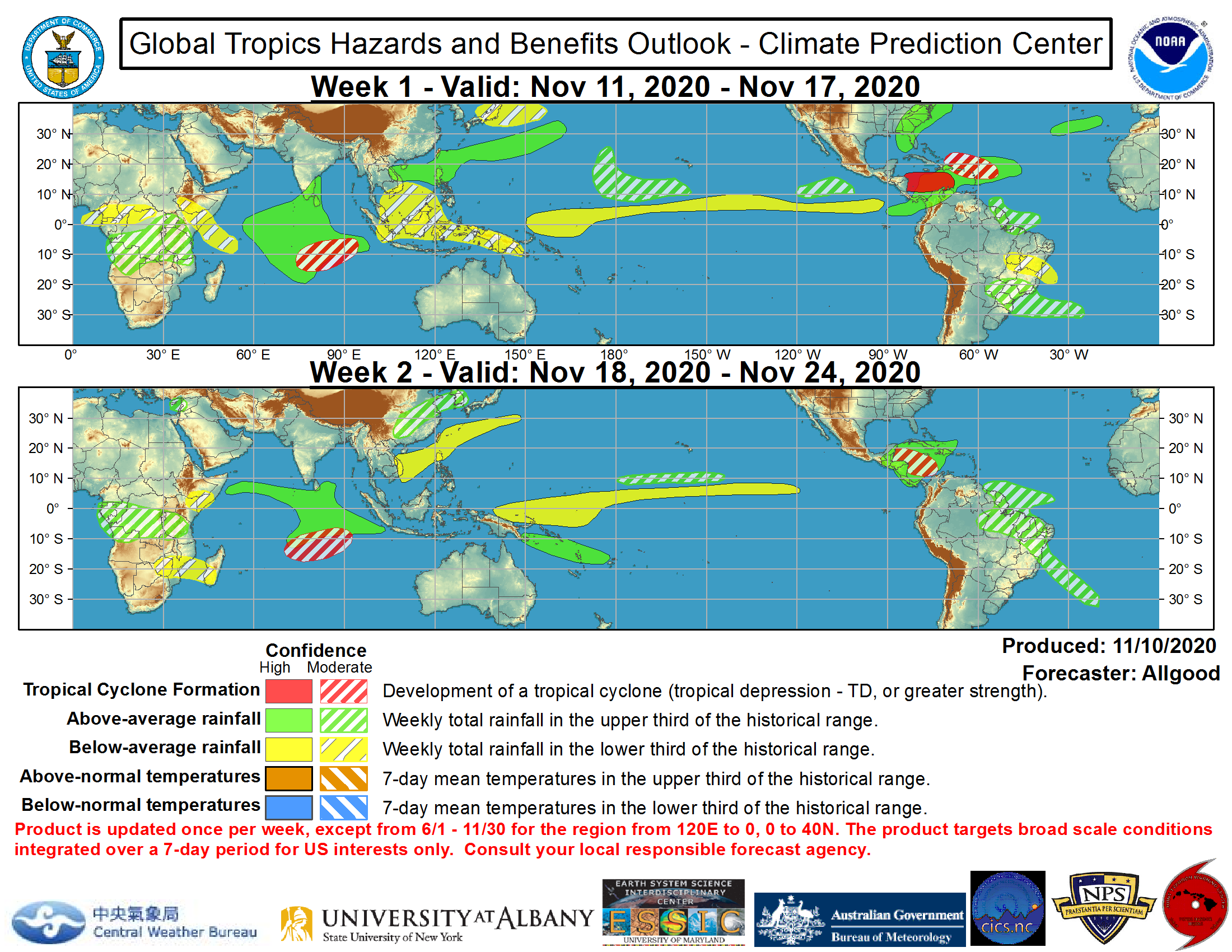
GLOBAL TROPICS HAZARDS -CLIMATE PREDICTIONS
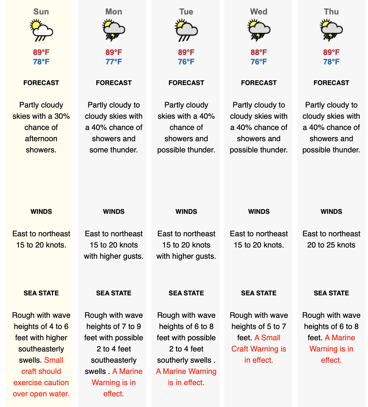
LOCAL 5 DAY FORECAST
See: http://www.weather.gov.ky/portal/page?_pageid=4421,7428393&_dad=portal&_schema=PORTAL
FOR RADAR IMAGE GO TO: http://www.weather.gov.ky/portal/page/portal/nwshome/forecasthome/rada
Also see Weather In Cayman: http://www.weatherincayman.com/
Moon info and graphic: https://www.timeanddate.com/moon/uk/georgetown
Tropical storm data and graphics from National Hurricane Center at: https://www.nhc.noaa.gov/
Weathernerds: http:// https://www.weathernerds.org/
Mikes Weather Page: http://www.spaghettimodels.com