Hurricane Warning issued as Tropical Storm Isaias takes aim at Carolinas, East Coast
From Weather.com
At a Glance
- Isaias will track into the Carolinas late Monday into early Tuesday.
- A hurricane warning is now in effect for parts of South Carolina and North Carolina.
- Storm surge flooding, strong wind gusts and heavy rain are all expected, there.
- Isaias will then sweep quickly through the mid-Atlantic and Northeast on Tuesday and Tuesday night.
- Flooding rain, damaging winds and some coastal impacts are expected in those regions.
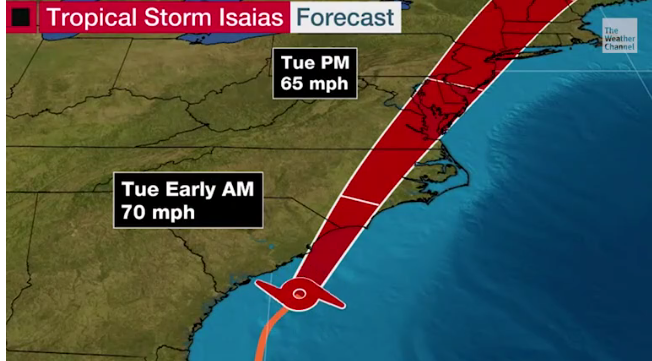
Tropical Storm Isaias (ees-ah-EE-ahs) is expected to regain hurricane strength before it pushes ashore into the Carolinas later Monday with damaging winds, flooding rainfall and storm surge flooding. The storm will then spread those impacts up the East Coast as far north as New England through Tuesday night.
Watches, Warnings and Current Conditions
A hurricane warning has been issued for a portion of the upper South Carolina and lower North Carolina coasts since Isaias is forecast to make landfall as a Category 1 hurricane tonight. The hurricane warning includes Myrtle Beach, South Carolina, and Wilmington, North Carolina.
Tropical storm warnings extend as far north as coastal Massachusetts. Tropical storm watches extend as far north as Maine.
The latest warnings and watches are depicted in the map below.
A watch means the respective conditions are possible within the next 48 hours. A warning means those conditions are expected within 36 hours.
(MORE: Hurricane Season Terms You Need to Know)

Isaias is currently centered south of the South Carolina coast. The storm is tracking to the north and will gradually turn toward the northeast.

Bands of rain with gusty winds are now rotating inland into the Carolinas. The rain will become more persistent and winds will grow stronger through tonight.

Latest Forecast
Isaias is forecast to briefly regain hurricane status before making landfall Monday night or early Tuesday on the upper South Carolina coast or in southeast North Carolina.
It’s important to note that impacts will be similar no matter whether Isaias is a strong tropical storm or a Category 1 hurricane at landfall.
From there, the storm will sweep quickly northeastward near parts of the Northeast Seaboard to as far north as New England Tuesday into early Wednesday.
(MORE: Mid-Atlantic, Northeast In-Depth Forecast)

Impacts
Wind
Hurricane conditions (winds 74 mph or greater) are possible in the hurricane warning area of South Carolina and North Carolina this evening and overnight.
Tropical storm conditions (winds 39 to 73 mph) will spread up the immediate East Coast through Tuesday night in areas under tropical storm warnings.

Remember, winds will be strongest near the coast and in high rise buildings.
There will be power outages and tree damage in locations that experience stronger wind gusts along the East Coast. This includes areas from the eastern Carolinas to the coastal mid-Atlantic, New York City, Long Island and parts of eastern New England.

Storm Surge
Dangerous storm surge flooding is possible in parts of the Carolinas.
A storm surge warning has been issued from Edisto Beach, South Carolina, to Cape Fear, North Carolina, the Pamlico and Albemarle Sounds, including the Neuse and Pamlico Rivers, and the North Carolina Outer Banks from Oregon Inlet to the border between North Carolina and Virginia.
A storm surge of 3 to 5 feet, above ground level, is expected if peak surge occurs at the time of high tide on the upper South Carolina and southeast North Carolina coasts. The highest surge should occur immediately to the east of where Isaias is expected to move ashore.
The high tide of most concern in the Carolinas is Monday evening.
According to the National Weather Service, the high tide Monday evening could hit major flood stage in Charleston, South Carolina.
Most other areas from northeast Florida to the coastal mid-Atlantic could see a storm surge of 1 to 4 feet above ground level, as depicted in the map below.

Swells generated by Isaias will ride up the East Coast ahead of Isaias, leading to high surf and the danger of rip currents. The high surf may only slowly fall after Isaias passes.
Rainfall Flooding
Isaias has the potential to produce the following rainfall totals along its path early this week, according to the National Hurricane Center.
-Carolinas and mid-Atlantic: 3 to 6 inches, with isolated maximum totals of 8 inches
-Southeast New York and much of New England: 2 to 4 inches, with isolated maximum totals of 6 inches.
The heavy rainfall could trigger significant flash flooding in some of these areas. Minor to isolated moderate river flooding is also possible in parts of the eastern states.
For more on possible impacts in the mid-Atlantic and Northeast,read our latest discussion here.

The threat of flooding rainfall has prompted the National Weather Service to issue flood watches from parts of the Carolinas to New England. These watches include Washington D.C., Baltimore, Philadelphia and the New York City Tri-State area.

Tornadoes
Isaias could also spawn short-lived tornadoes along its path up the East Coast.
An isolated threat is possible beginning late Monday and early Tuesday from eastern South Carolina into eastern North Carolina and far southeast Virginia.
The chance of isolated tornadoes could spread to the mid-Atlantic and Northeast coasts Tuesday into Tuesday night.
Storm History
Isaias is the earliest named ninth Atlantic tropical cyclone on record. The previous record was Irene on Aug. 7, 2005.
Typically the ninth named tropical system occurs in the Atlantic basin in early October, meaning this year’s pace is over two months ahead of average.
(MORE: The 2020 Atlantic Hurricane Season Is on a Record Pace)
The system developed from a large, vigorous tropical wave which emerged off the west coast of Africa around July 23-24.
On July 28, the National Hurricane Center designated the system “Potential Tropical Cyclone Nine”, a procedure allowing the issuance of tropical storm warnings for parts of the Lesser Antilles, Puerto Rico and the Virgin Islands before the system had actually become a tropical depression or storm.
Isaias finally became a tropical storm late on July 29, when it was centered about 150 miles south of Ponce, Puerto Rico.

Heavy rain triggered serious flash flooding in several areas of Puerto Rico. San Juan picked up 6.04 inches of rain from July 29-30. Parts of eastern Puerto Rico picked up over 10 inches of rain in 48 hour estimates from the National Weather Service.
Multiple fallen trees, mudslides and flooding were reported in southwest Puerto Rico, according to local emergency management. River flooding was recorded by USGS gauges in several locations in Puerto Rico.
(NEWS: Deadly Isaias Has Left Widespread Damage Across Dominican Republic, Puerto Rico)
Parts of the Dominican Republic picked up to 13 inches of rain from Isaias, according to the country’s national meteorological office.
Isaias’ center hopscotched across Hispaniola, then became a hurricane before brushing through the Inagua Islands.
Isaias then arrived in the Bahamas. Winds gusted to 56 mph at Nassau International Airport, and power was shut off to some parts of the island as a precaution on August 1.
(MORE: Isaias Impacts in the Bahamas)
The center of Isaias moved over northern Andros Island in the Northwest Bahamas, on August 1, where a gust to 69 mph was measured by a U.S. Navy site.
As it was doing so, wind shear temporarily blew thunderstorms away from Isaias, exposing the low-mid level core of Isaias in a stunning satellite loop.
Winds gusted to 62 mph Sunday morning in Freeport, Grand Bahama, hard hit 11 months ago from Hurricane Dorian.
What appeared to be at least a couple of feet of storm surge flooding was documented by Freeport resident Lean Burrows Sunday morning.
The Weather Company’s primary journalistic mission is to report on breaking weather news, the environment and the importance of science to our lives. This story does not necessarily represent the position of our parent company, IBM.
The Weather Company’s primary journalistic mission is to report on breaking weather news, the environment and the importance of science to our lives. This story does not necessarily represent the position of our parent company, IBM.