Why the western Caribbean Sea has been virtually hurricane-free since 2013
 By Jon Erdman From The Weather Channel
A region known for intense hurricanes has struggled to produce the past few years.
El Niño, wind shear and dry air have all worked against Caribbean Sea tropical cyclones recently.
The western Caribbean Sea, a notorious zone where some of the world’s most intense hurricanes are born, has been a relative tropical cyclone ghost town over the past three hurricane seasons.
Since the start of the 2013 hurricane season, only one of the 33 Atlantic Basin storms has managed to exist in the western Caribbean Sea, and that was a brief pulse from Tropical Storm Hanna in late October 2014.
The eastern Caribbean Sea has been only slightly more active during that period, with several tropical storms fizzling instead of intensifying: 2015’s Tropical Storm Erika, its immediate predecessor Hurricane Danny, and 2013’s Tropical Storm Chantal. Most other 2013-2015 tracks remained north of the Caribbean Sea.
Why the Caribbean Dearth?
In 2015, what would eventually become a record-tying strong El Niño had a heavy hand on the hurricane season.
Wind shear – the change in wind direction and/or speed with height, which tends to rip apart tropical cyclones – set a Caribbean Sea record for any June-October period in 2015, according to Colorado State University tropical scientist Dr. Phil Klotzbach.
An abundance of dry air, which disperses convection away from the center due to the production of stronger downdrafts, played a role in the eventual demise of both Danny and Erika in the Caribbean. Despite this, Erika still brought disastrous flooding to Dominica in late August 2015.
Danny was probably the best example of the Caribbean Sea “deflector shield,” ramming into a wall of wind shear and dry air upon approach to the Windward Islands, going from a brief Category 3 hurricane to completely fizzled before completely leaving the islands.
The previous season, thanks again to the combination of strong wind shear and dry air, only one hurricane formed anywhere near the Caribbean Sea. That was Hurricane Gonzalo, which brought hurricane-force winds to parts of the northern Leeward Islands in mid-October 2014.
In 2013, several strong outbreaks of dry air over the tropical Atlantic Basin, along with bouts of increased wind shear, led to the first season in 19 years without a single Category 3 or stronger hurricane. A pair of tropical storms was all the Caribbean Sea could muster.
The Luck Will Run Out
The recent lack of tropical systems means you can simply book your Caribbean getaway in August, September or October, put hurricanes out of your mind and save money on travel insurance, right?
Don’t bet on it.
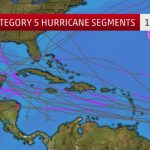
Since 1950, half of the 22 hurricanes that reached Category 5 status in the Atlantic Basin did so in the Caribbean Sea.
This includes the two strongest Atlantic hurricanes on record, in terms of central pressure: 2005’s Hurricane Wilma and 1988’s Hurricane Gilbert.
The last Category 5 Atlantic hurricanes, 2007’s powerful duo of Dean and Felix, were both in the Caribbean Sea.
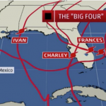
From 2004-2008 seasons, 14 hurricanes plowed through at least parts of the Caribbean Sea, an average of almost three per season. Among those were three notable hurricanes: Ivan, Wilma and Emily.
The western Caribbean Sea is home to one of the great reservoirs of deep, warm water on the planet to fuel tropical cyclones.
Once anomalous wind shear and dry air pull back, hurricanes and tropical storms will return to this recently forgotten but tropically notorious region.
Jonathan Erdman is a senior meteorologist at weather.com and has been an incurable weather geek since a tornado narrowly missed his childhood home in Wisconsin at age 7.
IMAGES:
Atlantic named storm tracks from 2004-2008, highlighting the active Caribbean Sea.
Category 5 track segments (purple) in the Atlantic Basin from 1950 through 2015.
Wind shear analysis in the Atlantic Basin on Sep. 5, 2015. Higher shear is shown by the purple and dark red contours. Note the enhanced wind shear in the Caribbean Sea, a time of year when wind shear is typically at its lowest.
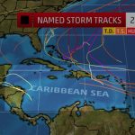
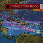
Named storm tracks (tropical storm or stronger) in the 2013 through 2015 Atlantic hurricane seasons, showing the relative dearth of activity in the Caribbean Sea.
For more on this story and video go to: https://weather.com/storms/hurricane/news/caribbean-sea-hurricane-drought-2013-2015


