Uptick in Atlantic tropical systems may continue as new features bear watching
 By Alex Sosnowski, AccuWeather senior meteorologist From Accuweather
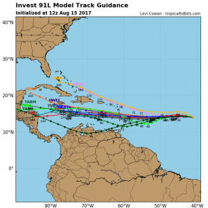
In the wake of Gert, a large batch of thunderstorms over the central Atlantic Ocean has the potential to spawn a tropical depression and storm this week.
Gert will turn away from North America but has become the second hurricane of the 2017 Atlantic season.
Thousands of miles farther to the southeast, a plume of moisture continues to grow westward from Africa to the south-central Atlantic.
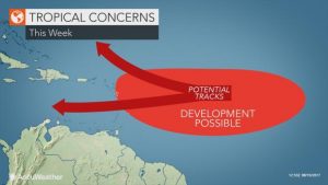
Interests from the northern islands of the Caribbean to the Bahamas and coastal areas in the southeastern and south-central United States may want to monitor the progress of this area of disturbed weather.
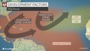
Most of the inhibitive dust, dry air and strong westerly winds aloft may remain north of the path of the area of concern through this week. The lead system may pave the way for others in the train.
“There is the potential for this large area of moisture to spawn a tropical depression or storm this week and perhaps as early as Wednesday,” according to AccuWeather Hurricane Expert Dan Kottlowski.
Additional systems may follow over the next several days, since there are three areas of disturbed weather over the south-central and southeastern Atlantic.
Part of this moisture plume was responsible for producing flash flooding and mudslides in Sierra Leone at the start of this week. Hundreds were killed, according to the Associated Press.
As is often the case this time of the year, “the area of disturbed weather will move in a general west or slightly north of west path this week,” Kottlowski said. “This will bring the lead system into the Lesser Antilles late in the week.”
Until any of the features develop, future paths of movement may be very misleading and should be used with caution at this point, Kottlowski stated.
There are a number of factors that could pull the features to the north on a path similar to Gert or allow a more westward track over the northern Caribbean and perhaps into the Gulf of Mexico.
The difference with the setup for Gert versus some of the new features is that a path into the Caribbean and Gulf of Mexico was not a significant option for Gert.
The strength of the features, geography and the position of other weather systems over the eastern United States and the Atlantic Ocean by next week are at the top of this list of factors that may affect movement.
For example, a weak feature may have a greater chance of staying on a westerly course for a longer period of time. A well-developed feature, such as a tropical storm or hurricane, may have a greater chance of taking a curved path to the northwest and north much sooner.
Most westward-moving, well-developed tropical systems tend to pass to the north or south of the Greater Antilles, due to the mountainous terrain.
More information on the path and strength of this new feature will become available as the week progresses.
IMAGES:
Static 91L still image Monday PM
Static Tropical Development Factors
Static Tropical Concerns This Week v 2
For more on this story go to: https://www.accuweather.com/en/weather-news/uptick-in-atlantic-tropical-systems-may-continue-as-new-feature-bears-watching/70002455
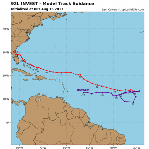
Graphics – Invest 91L & 92L From Mikes Weather Page http://www.spaghettimodels.com/https://www.accuweather.com/en/weather-news/uptick-in-atlantic-tropical-systems-may-continue-as-new-feature-bears-watching/70002455


