Tropical Depression 16 forms today (Wed 4). Forecast to be a hurricane
 From NHC
Tropical Depression Sixteen Discussion Number 1
NWS National Hurricane Center Miami FL AL162017
1100 AM EDT Wed Oct 04 2017
Satellite images indicate that the area of low pressure in the southwestern Caribbean Sea has become better organized since yesterday and is now a tropical depression. GOES-16 one-minute visible data suggest the center is in between two large curved bands of deep convection, not too far from San Andres Island. The initial wind speed is set to 30 kt, somewhat above the TAFB satellite classification, given recent microwave data. An Air Force Reserve Hurricane Hunter aircraft should be in the area this afternoon to provide a better estimate.
Other than land interaction between 24-36 hours, environmental conditions look conducive for intensification of the depression. A large mid/upper-level trough is forecast to drop over the SW Gulf of Mexico, providing a low-shear environment for the cyclone. Rapid intensification is a possibility over the northwestern Caribbean or southern Gulf of Mexico while the system is traversing rather warm and deep waters, although it remains to be seen how separate the depression becomes from a larger gyre over central America. The official intensity forecast is close to the SHIPS model, on the high side of the intensity guidance since much of the GFS-based tracks show much more land interaction than the official forecast.
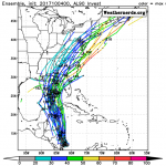
The depression is moving slowly northwestward this morning, around a distant mid-level ridge over the southwestern Atlantic Ocean. However the steering pattern should change quickly tomorrow as the aforementioned mid-tropospheric trough moves across the northwestern Caribbean into the southwestern Gulf of Mexico. Southerly flow on the eastern side of that trough should cause the cyclone to move much faster to the north-northwest by Friday and northward into the Gulf of Mexico on Saturday. As the trough moves away, a building ridge over the southwestern Atlantic is forecast to steer the system to the north-northeast or northeast toward the northern Gulf states. There is a fair bit of model spread for now, partly owing to the representation of the Florida Straits trough. The GFS-based guidance seems to over-amplify the trough, which causes the new tropical cyclone to be pulled northwestward longer than most of the rest of the models. Consequently, this forecast is closer to the
UKMET and ECMWF models, on the right side of the model consensus, but must be considered a low-confidence prediction at this time.
KEY MESSAGES:
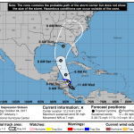
1. The depression is forecast to strengthen and bring tropical storm conditions and heavy rainfall to portions of Nicaragua and Honduras tonight through Thursday.
2. The system is forecast to continue strengthening over the Gulf of Mexico and could affect portions of the northern Gulf Coast as a hurricane this weekend, with direct impacts from wind, storm surge,
and heavy rainfall. However, it is too early to specify the timing or magnitude of these impacts. Residents along the Gulf Coast from Louisiana to Florida should monitor the progress of this system forthe next several days and heed any advice given by local officials.
FORECAST POSITIONS AND MAX WINDS
INIT 04/1500Z 12.2N 81.9W 30 KT 35 MPH
12H 05/0000Z 12.7N 82.6W 35 KT 40 MPH
24H 05/1200Z 13.8N 83.5W 40 KT 45 MPH…INLAND
36H 06/0000Z 15.3N 84.1W 35 KT 40 MPH…INLAND
48H 06/1200Z 17.9N 85.0W 45 KT 50 MPH
72H 07/1200Z 23.5N 87.0W 60 KT 70 MPH
96H 08/1200Z 29.0N 86.0W 70 KT 80 MPH
120H 09/1200Z 34.5N 82.5W 30 KT 35 MPH…POST-TROP/INLAND
Forecaster Blake