Matthew dumping extreme rains; threat to southeast U.S. growing
 By: Jeff Masters and Bob Henson , 6From Weather Underground
Very dangerous Hurricane Matthew is maintaining Category 4 strength as it heads northwards at 6 mph, and is already dumping potentially catastrophic rains on Haiti and the Dominican Republic. An unusual area of extra spin and low pressure that has been embedded on the east side of Matthew’s circulation for days is generating intense rains in excess of one inch per hour, as seen on microwave imagery (Figure 1.) A portion of this feature rotated ashore over southern Haiti and the Dominican Republic early Monday morning, and the mountainous terrain of this region undoubtedly caused additional uplift that resulted in rainfall rates much higher than one inch per hour. A personal weather station in Cabo Rojo, on the southern coast of the Dominican Republic near the border with Haiti, recorded 20.05” of rain in eleven hours between 3 am and 2 pm on Monday, including a remarkable 5.33″ in the hour from 6 am to 7 am. While PWS data is often suspect, these are believable rainfall amounts based on the satellite presentation of Matthew. The outer spiral bands of Matthew are also affecting Jamaica, as seen on Jamaican radar (see long loop saved by Brian McNoldy, Univ. of Miami, Rosenstiel School.)
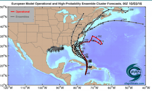

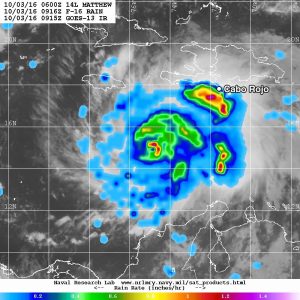
Figure 1. Microwave image of rainfall rates in Hurricane Matthew from the F-16 polar orbiting satellite taken at 5:16 am EDT October 3, 2016. At the time, Matthew was a Category 4 storm with 130 mph winds. Rainfall amounts in excess of 1”/hour (orange colors) were occurring along the coasts of Haiti and the Dominican Republic. This intense area of rainfall moved ashore a few hours later, bringing 5.33” of rain in one hour to Cabo Rojo. Image credit: NRL Tropical Cyclone Page.
An Air Force hurricane hunter aircraft made four passes through the eye of Matthew on Monday morning and early Monday afternoon, and found surface winds as high as 140 mph. The central pressure stayed in the 940 – 941 mb range during all the passes, so it does not appear that Matthew is undergoing intensification. Satellite loops on Monday morning showed that Matthew’s eye was clearing out and becoming more distinct, and the hurricane’s cloud pattern was becoming more symmetric–signs the storm may be about to intensify, though. Light wind shear of 5 – 10 knots is affecting the storm, and Matthew is over warm ocean waters of 29°C (84°F) and has plenty of moisture to work with: 70 – 75% relative humidity at mid-levels of the atmosphere, as analyzed by the SHIPS model.
Matthew passed over NOAA buoy 42058 early Monday morning, and top winds during passage of the weaker portion of the eyewall were 74 mph, gusting to 92 mph. Seas were 34 feet, and the buoy recorded a minimum pressure of 943 mb. The wind measurement height on the buoy was 5 meters, so an upwards correction of about 10 mph is needed to adjust these numbers to the standard 10-meter observing height for winds.
Figure 2. The GOES East satellite captured this image of Hurricane Matthew, located about 220 miles southeast of Kingston, Jamaica, at 9:15 am EDT on October 3, 2016. Image credit: NOAA Visualization Lab.
Intensity forecast for Matthew
The latest SHIPS model forecast predicts that wind shear will remain light to moderate, 5 – 15 knots, for the next five days. Ocean temperatures will be very warm, between 29 – 30° C (84 – 86°F) and the heat content of the ocean will be high to very high, which argues for intensification of Matthew. At any time, though, Matthew could undergo an eyewall replacement cycle (ERC), where the inner eyewall collapses and is replaced by a larger-diameter eye, with a new eyewall formed from an outer spiral band. This process usually causes a weakening to the storm’s top winds for a day or so. The down side of an ERC is that is spreads out the storm’s hurricane-force winds over a wider area, resulting in severe impacts over a wider area. Our top three intensity models–the HWRF, LGEM, and SHIPS models–were predicting on Monday morning that Matthew would be at Category 3 or 4 strength for the next four days. The SHIPS model gave Matthew an 11% chance of rapid intensification of 30 mph or more by Tuesday morning. Landfall in eastern Cuba/northwest Haiti on Tuesday could act to disrupt the hurricane and destroy its inner core, which might knock Matthew down to Category 2 strength for several days. However, Matthew will probably re-intensify by at least 20 mph in the two days after its landfall in Cuba/Haiti.
Three-day track forecast for Matthew
Matthew will make landfall or pass very close to the southwest tip of Haiti early Tuesday morning, then make a second landfall in eastern Cuba on Tuesday afternoon. Matthew will then traverse The Bahamas from southeast to northwest Tuesday evening through Thursday morning. In their 11 am EDT Monday Wind Probability Forecast, NHC gave highest odds of hurricane-force winds to Les Cayes in southwest Haiti (35%) and to Guantanamo Bay, Cuba (41%). Lower odds were given to Kingston, Jamaica (0%) and Port-Au-Prince, Haiti (2%). In The Bahamas, hurricane-force wind odds of 39% were given to Great Exuma, 24% to New Providence, and 35% to San Salvador. See our post from earlier Monday morning for more on how Matthew–a rare northward-moving major hurricane in the Caribbean–fits into the hurricane histories of Haiti, Jamaica, and Cuba.
98L: probably no steering influence on Matthew
An area of low pressure associated with a tropical wave that (designated Invest 98L by NHC on Sunday morning) is over the central tropical Atlantic several hundred miles north-northeast of the northern Lesser Antilles. Over 50% of the members of the 00Z Monday European ensemble forecasts predicted that this system would develop into a tropical depression or tropical storm as it heads west-northwest to northwest at 10 – 15 mph; the GFS model showed virtually no development. In their 2 pm EDT Monday Tropical Weather Outlook, NHC gave this system 2-day and 5-day odds of development of 50%. Satellite loops on Monday morning showed that 98L had a very limited amount of heavy thunderstorm activity that had acquired a respectable amount of spin. High wind shear of 30 knots was affecting 98L, and the 12Z Monday SHIPS model forecast predicted wind shear would rise even higher by Tuesday–in excess of 45 knots. This level of shear will likely keep any development of 98L rather limited, and we doubt 98L will be able to exert a significant steering influence on Matthew.
Figure 3. Track forecasts from the four European model ensemble members [gray lines] that most closely match the operational run [red line] during the first 72 hours, starting at 00Z Monday, October 3, 2016. The red line is a version of the 00Z Monday operational model track that has been adjusted and calibrated using a proprietary technique to account for systemic model errors. Four out of five of these forecasts showed Matthew making a double landfall in the U.S.: first in Florida, then farther north. The high-probability cluster (grey lines) perform better than other ensemble members at forecast times of five days and beyond. Image credit: Climate Forecast Applications Network (CFAN).
Beyond The Bahamas: landfall threat for Southeast U.S. increasing
A significant westward shift in computer model guidance on Hurricane Matthew has occurred, and this could have big implications for the hurricane’s potential impact on the U.S. East Coast. The main reason appears to be stronger ridging south of 98L and north of Matthew than earlier predicted, which may help to nudge Matthew far enough west for major impacts along the Southeast U.S. coast. Last night’s 50 ensemble runs from the 00Z Monday European model included a number of tracks making landfall along the U.S. East Coast. Most concerning is that, for the first time in Matthew’s life, all four members of the Euro “high-probability” cluster–the members that most closely match the operational run–depict Matthew making landfall on Florida’s East Coast. (The 12Z Monday run of the NAM model also depicts the stronger ridge and suggests a Florida landfall, but the NAM is not designed to handle tropical cyclones and should be avoided for hurricane prediction, unless perhaps you’re Bart Simpson.)
Lending further credence to the westward shift are the latest 12Z Monday operational runs of our other two top track models, the GFS and UKMET. The 12Z UKMET brings Matthew into the East Coast of Florida, while the GFS brings Matthew considerably closer to the Florida coast than earlier runs, with a projected landfall in northern South Carolina this weekend (see Figure 4 below) and a second landfall on Cape Cod less than 36 hours later. The several previous operational GFS runs had suggested that a Southeast landfall would be limited to the NC Outer Banks at most. Likewise, the 12Z Monday GFS ensembles (GEFS) now include a majority of runs making landfall somewhere between Florida and North Carolina, a major shift west from previous GFS ensembles. In addition, the 12Z Monday run of the HWRF model is tracking about 1 degree (roughly 60 miles) west of its previous two runs, now showing a potential landfall in eastern North Carolina by late Friday.
Figure 4. Comparison of GFS operational model output from (left) 06Z Monday and (right) 12Z Monday. Black lines denote surface air pressure; colors denote the height of the 500-millibar surface, roughly the midpoint of the atmosphere, in tens of meters. The more recent guidance (right) shows a stronger ridge (deeper orange colors) to the east and north of Matthew, keeping it further to the west as it moves northward. Long-range models such as the GFS are much less skillful at projecting hurricane intensities than hurricane tracks. Image credit: tropicaltidbits.com
In our next update this evening, we’ll look at results from the 12Z Euro and GFS ensemble runs and the 12Z Euro operational run. For now, it’s important to keep in mind that the uncertainty “cones” produced by NHC are not tailored specifically for a given hurricane: they are based on the average error in NHC forecasts over the preceding five years. On average, about two-thirds of all hurricanes stay within the cone, but some hurricanes are tougher to predict than others. Given the wide range of model guidance on Matthew, and the recent westward shift, the actual uncertainty for this hurricane may be wider than the 120-hour cone location implies. In any event, there is enough model support for various possibilities that people all the way from Florida to Maine should continue to take seriously the possibility of impacts from Matthew. As always, the NHC is the place to turn for official 5-day forecasts, including intensity and track guidance and cones of uncertainty.
Figure 5. WU depiction of official NHC hurricane forecast through 12Z (8:00 am EDT) Saturday, October 8.
Jeff Masters and Bob Henson
For more on this story go to: https://www.wunderground.com/blog/JeffMasters/comment.html?entrynum=3460


