Hurricane Hunters find hurricane-force winds in Matthew; wind shear attacking storm
 By Jeff Masters From Weather Underground
Tropical Storm Watches are posted for the ABC islands of the Netherlands Antilles—Aruba, Bonaire, and Curacao—as Tropical Storm Matthew advances westwards at 16 mph across the eastern Caribbean. An Air Force hurricane hunter aircraft was in Matthew on Thursday morning, and at 9 am EDT found hurricane-force winds of 75 mph in a small region to the northeast of the storm’s center. Surface winds were a bit lower in data from the airborne stepped frequency microwave radiometer (SFMR), and based on this, the National Hurricane Center held Matthew’s top sustained winds at 70 mph, just shy of hurricane strength, in its 11 am EDT advisory. Satellite loops on Thursday morning showed that Matthew was showing the classic signs of a storm struggling with high wind shear—the center was fully exposed to view, and Matthew’s heavy thunderstorms were limited to the northeast side, thanks to strong upper-level winds out of the southwest that were creating high wind shear of 20 – 25 knots.

Matthew has grown to impressive size, with its heavy thunderstorms extending from the northern coast of South America to the northern Lesser Antilles Islands, and if it weren’t for the high wind shear affecting it, Matthew would fill the entire eastern Caribbean. At upper levels, high cirrus clouds streaming to the north of Matthew show the presence of a powerful outflow channel, which is helping ventilate the storm and allowing it to hold its own in the face of the high wind shear. There is also evidence of a second outflow channel becoming established to Matthew’s south, which one can see in the latest Upper Level Winds analysis from the University of Wisconsin CIMSS group. If this second outflow channel becomes well-established, rapid intensification of Matthew becomes more likely if the wind shear affecting the storm relaxes. Aiding development today were warm ocean waters of 29.5°C (85°F). The 8 am EDT Thursday SHIPS model output analyzed 50 – 55% relative humidity at mid-levels of the atmosphere over Matthew, which is lower than optimal for tropical cyclone formation, and water vapor satellite loops showed Matthew was butting into a region of dry air.
Figure 1. Latest satellite image of Matthew.
Three-day forecast for Matthew
Matthew will continue west through Friday, slowing down from a forward speed of 15 mph on Thursday morning to 5 – 10 mph by Friday night. The core of the storm will make its closest approach to the ABC islands of the Netherlands Antilles—Aruba, Bonaire, and Curacao—on Friday. These islands will be on the weak (left) side of the storm, and may escape receiving tropical storm winds, though rains of 1 – 2” can be expected. Given the high wind shear currently affecting Matthew, no intensification is likely the remainder of Thursday, and we may even see a weakening of the storm’s winds. The latest SHIPS model forecast predicts that the wind shear will drop to the low range, less than 10 knots, by Saturday. If this forecast verifies, we should some some gradual intensification on Friday, followed by more rapid strengthening on Saturday and Sunday.
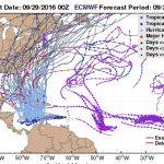
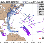
Figure 2. The 70 forecasts from the 00Z Thursday European (ECMWF) model ensemble (top) and GFS model ensemble (bottom) showed a wide variety of solutions for the track of Matthew. The operational (deterministic) versions of the models, run at higher resolution, are shown in red lines. The two models have grown closer together in their solutions compared to Wednesday, but the European model still shows a considerably slower and more westerly track for Matthew than the GFS model.
Longer-range forecast for Matthew
Huge differences continue in the longer-range model forecasts for Matthew. A large upper-level low pressure system has separated from the jet stream and will meander over east-central U.S. during the remainder of this week. The steering currents associated with this low are expected to be strong enough to pull Matthew sharply to the north by the weekend. This sharp turn is expected to occur on Friday night or on Saturday, and the exact timing of the turn has major implications for who experiences the peak wrath of the storm. An earlier turn is being predicted by the GFS model, with a landfall by the storm in eastern Cuba on Monday morning. Matthew is then predicted to move through the central Bahamas on Tuesday. The European model has Matthew heading northwards more than a day later than the GFS model, with a landfall in Haiti on Tuesday morning. As one can see from the latest set of ensemble model runs (Figure 2), the long-range uncertainties in Matthew’s long-range track are high. Hopefully, these forecast discrepancies will be resolved by Friday morning, when data from the NOAA Gulfstream-IV jet on the environment surrounding Matthew will be available. This aircraft (nicknamed “Gonzo”), whose dropsondes can improve track forecasts by as much as 20%, will make its first flight Thursday evening. It’s good to have “Gonzo” back, as it was down for extended maintenance in late August and early September due to a corrosion problem, and was not available at all during Hurricane Hermine.
Matthew is expected to have favorable conditions for intensification this weekend as it heads north, with low wind shear, very warm ocean waters, and a very moist atmosphere. The models are quite bullish on this storm being a hurricane when it makes its landfall early next week in the islands, and residents of Jamaica, Haiti, and eastern Cuba should anticipate the possibility of a Category 2 hurricane–possibly stronger–affecting them early next week.
Figure 3. How strong could Matthew get? On rare occasions, when wind shear is low and dry air is absent, a hurricane will become a “perfect storm”, reaching the maximum potential intensity (MPI) that physics will allow. This maximum is a function of how warm the ocean is and how unstable the atmosphere is. Last year’s Hurricane Patricia, which intensified to 215 mph sustained winds over record-warm waters of 31°C (88°F) off the Pacific coast of Mexico, was one example of such a rare “perfect storm.” Hurricane scientist Dr. Kerry Emanuel of MIT has developed a relatively simple set of equations which will determine the approximate MPI of a hurricane, and real-time plots of this are available at wxmaps.org. In the case of Matthew, its MPI if it was in the region between Jamaica and Haiti today would be approximately 150 knots (170 mph), seen in the dark blue colors. If Matthew were in the northeast Bahamas, where ocean temperatures are warmer and the atmosphere more unstable, the MPI is higher, near 165 knots (190 mph), seen in black colors. These MPI numbers will change slightly when and if Matthew reaches these areas several days from now. Keep in mind that “prefect storm” conditions are difficult to achieve, and it is quite unlikely that Matthew will reach its MPI.
For more on this story go to: https://www.wunderground.com/blog/JeffMasters/comment.html?entrynum=3450


