First predictions of 2019 hurricane season released
By Nick Austin from Freight Waves

Spring is only a few weeks old, and the last hurricane season ended just a little more than four months ago. But it’s already time to look ahead to the next Atlantic hurricane season which starts on June 1. Earlier this month, the hurricane research team at Colorado State University released its initial predictions for this year. The highly-respected team has been issuing its tropical outlook for more than 35 years, and right now it looks like the U.S. might catch a slight break this hurricane season, after some brutal weather this winter and so far this spring.
SOURCE: COLORADO STATE UNIVERSITY
First, A Look Into The Recent Past
In 2018, 15 named storms developed in the Atlantic basin, which includes the Caribbean Sea and the Gulf of Mexico. Eight were hurricanes, and two were major hurricanes (Category 3 strength or higher on the Saffir-Simpson wind scale), including Hurricane Michael. That storm made landfall in Mexico Beach, Florida on October 10 with winds of 155 mph, just shy of Category 5 strength. Michael was one of the most intense hurricanes to ever hit the U.S., and, in terms of central barometric pressure, it was the third-strongest hurricane on record to make landfall in the U.S. Michael had the strongest winds in a land-falling hurricane since Andrew hit southern Florida in August 1992. Economists predict Michael will cost $25 billion.
In September 2018, Hurricane Florence made a sluggish landfall in the Carolinas, dumping more than 30 inches of rainfall that flooded parts of the region for days. More than a dozen rivers crested at major flood stages, leading to evacuations and catastrophic property damage. Florence broke flooding records previously set during hurricanes Floyd in 1999 and Matthew in 2016, with damage estimated at around $25 billion.
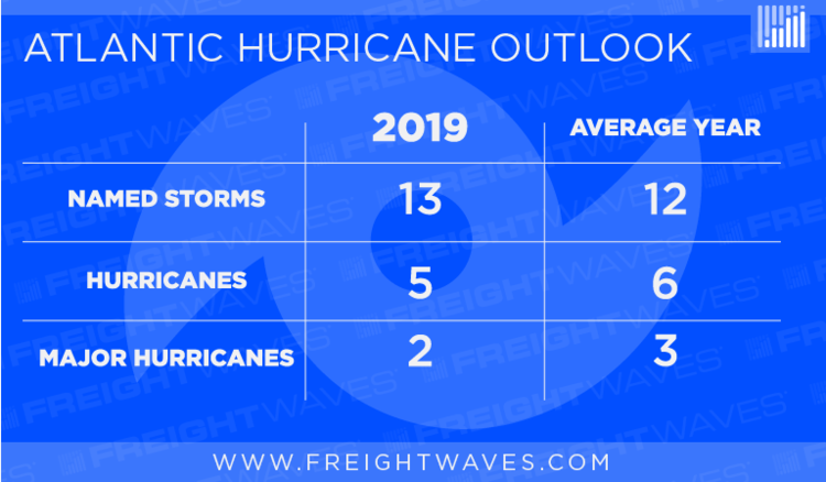
Now, The Look Ahead
The Colorado State team is forecasting a total of 13 named storms. A storm is named as soon its maximum sustained winds reach 39 to 73 mph, which is Tropical Storm status. More specifically, the outlook says that five of the named storms will become hurricanes (winds of at least 74 mph), and two of the hurricanes will become major hurricanes. It’s important to note that this outlook does not attempt to determine where storms might develop or how many might make landfall in the U.S.
This year’s outlook is similar to what’s considered an average season of 12 named storms (of those, six will become hurricanes and three will become major hurricanes). The number of predicted storms is close to normal, but the overall activity, which is based on the intensity of storms and their energy, is forecast to be slightly below average. The Colorado State University team has to consider the state of the current El Niño, as well as the setup of Atlantic Ocean temperatures when preparing its outlook. Both factors are pointing to a less-than-active season.
In general, El Niño conditions – warmer than average sea surface temperatures (SST) in the Pacific – tend to suppress Atlantic hurricane formation as a result of strong upper-level winds that “shred” developing hurricanes. Predicting changes in El Niño is extremely difficult during the spring. So, whether it will continue through the rest of the year is still to be determined.
The tropical Atlantic is currently slightly cooler than normal, while the far North Atlantic and subtropical Atlantic are much warmer than normal. This ocean temperature pattern is typically what is observed in less-active hurricane seasons, since strong hurricanes tend to form in the deep tropics.

SOURCE: NOAA
Stacking Up
Colorado State University’s early forecasts over the past few years have turned out to be fairly accurate. The 2018 forecast, for example, called for seven hurricanes. That season produced eight. In 2016, the forecast called for six hurricanes, and seven formed.
But like other forecasters, Colorado State underestimated the number of hurricanes that would be produced in the 2017 season. The team’s outlook predicted four hurricanes for a season that ended up with 10, including the massively destructive Harvey, Irma and Maria.
This year’s forecast from Colorado State is slightly more optimistic than the one released Wednesday by AccuWeather, a private weather service that predicted five to seven hurricanes. The forecast warned that even below-average seasons can produce catastrophic hurricanes.
April’s forecast is the first one issued by Colorado State University each year. These forecasts are updated in early June, July and August. The forecast accuracy increases closer to the peak of the season (August through October). Typically, the accuracy of El Niño forecasts also improve, and the SST pattern in the Atlantic has increased predictability from spring to summer. The Atlantic hurricane season runs from June 1 through November 30, but about 95 percent of all major hurricanes occur after August 1.
For more on this story go to; https://www.freightwaves.com/news/weather/first-predictions-of-2019-hurricane-season-released


