Category 2 Florence nears landfall in North Carolina; Catastrophic flooding expected
 By Dr. Jeff Masters From Weather Underground
Heavy rains from Category 2 Hurricane Florence are lashing the coast of North Carolina as the dangerous storm heads northwest towards an expected landfall on Friday. Florence may be a Category 2 hurricane by the Saffir-Simpson wind scale, but it is a Category 5 heavy rain and inland flooding threat. Florence will stall on Friday and move slowly west-southwest along the coast for several days, bringing a devastating rainfall and storm surge event.
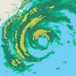
Radar data from the Morehead City, NC radar showed that Florence’s outer spiral bands began dumping heavy rains over the Outer Banks and much of Eastern North Carolina on Thursday morning. Rainfall amounts of 0.5 – 1.0 inch per hour were common, with a few heavy cells generating higher rainfall rates. A Personal Weather Station in Emerald Isle, NC picked up 2.9” of rain in just 40 minutes at 10 am EDT.

At 10:58 am EDT, winds at Beaufort, NC were sustained at 31 mph, gusting to 52 mph.
At 11 am EDT, winds at buoy 41063 20 miles south of Ocracoke Inlet, NC were sustained at 45 mph, gusting to 60 mph.
Florence forecast
Intensity forecast for Florence: little change before landfall
Florence’s environment is still conducive for intensification, but the storm is not well-structured to do so, and the hurricane is quickly running out of time for any intensification to occur. The SHIPS model predicts shear will remain a moderate 10 – 15 knots through Saturday, SSTs will be a warm 29°C (84°F) during this period, and ocean heat content will be lower than before, near 20 kilojoules per square centimeter. Given Florence’s lack of a complete eyewall, significant intensification is unlikely, and we can expect the hurricane to gradually weaken as land interaction increases and the slower motion of the storm upwells cold water from the depths. Our top three intensity models predict Florence will be a borderline Category 1/Category 2 hurricane with 95 – 105 mph winds at landfall.
Florence forecast
Track forecast: a stall near the North Carolina coast, then west-southwest to west motion
The latest 0Z Thursday runs of our top five track forecasting models were similar to their previous 12Z runs, agreeing that Florence would head towards the North Carolina coast through Thursday evening, as the clockwise flow around the Bermuda High pushes the storm northwest. But on Thursday night, Florence will put on the brakes and screech to a halt as the steering currents collapse. Given that the steering currents will be very weak Friday and beyond, slight changes in the balance between these forces guiding the hurricane will make a huge difference in where the hurricane makes landfall. This makes the exact landfall location a time difficult to predict accurately. Landfall will be between 2 am and 10 am EDT Friday, according to the five models.
The most concerning forecast continued to be from our top model for forecasting hurricanes, the European model, whose 0Z Thursday run predicted that Florence’s stall would occur very near shore along the NC/SC border, with the hurricane then traversing the northern half of the coast of South Carolina just offshore, until making landfall Saturday night near Charleston. This would allow Florence to keep its eye over water, greatly increasing the amount of rain it can generate, and would subject a very long stretch of coast to high winds and a destructive storm surge. Our other top models–the GFS, HWRF, UKMET, and HMON–all predicted Florence would move ashore near the NC/SC border, then turn to the west-southwest over land. On this track, Florence would still keep a large part of its circulation overwater and dump extreme rains, but would not bring a devastating storm surge and hurricane-force winds to a long stretch of coast. By Sunday, Florence should be headed due west towards the Appalachian Mountains.
Catastrophic flooding expected from extreme rainfall
Florence’s stall near the coast and slow motion will result in prodigious amounts of rain. If a significant portion of the storm’s circulation remains over water, as occurred last year with Hurricane Harvey’s stall over Southeast Texas, the rain from Florence may break all-time state records for rainfall from a hurricane or tropical storm. North Carolina’s state rainfall record from a hurricane is 24.06” from Hurricane Floyd of 1999, South Carolina’s is 18.51” from Tropical Storm Jerry of 1995, Virginia’s is 27.00” from Hurricane Camille of 1969. The 11 am EDT Thursday advisory from NHC warns of the potential for isolated totals of 40″ near the coast of North Carolina and far northeast South Carolina, which would smash the current record in either state. Soils are near saturation in some areas of Florence’s likely heavy rain zone, thanks to a record-wet summer. Heavy rains run off of wet soils and create bigger floods.
The bottom line: Florence’s rains are likely to bring catastrophic flooding to a large region along the track of the storm.
Storm surge warning for Florence, 15Z 9/13/18
Prolonged surge event to chew on the Carolina coast
Florence’s wind field has put a large region of ocean into motion, which is already increasing water levels along the coast of North and South Carolina. As of 11 am EDT Thursday, surge levels of 0.5 – 1.0 feet were being observed along the coasts of North and South Caolina (see the SURGEDAT storm surge update page for live storm surge values along the path of Florence). The surge threat from Florence is higher than you might expect from its Saffir-Simpson category, because the storm is large and will be affecting the coast for a prolonged period. For example, Hurricane Ike in 2008, another former Category 4 storm, also weakened to Category 2 before landfall on Galveston Island, but it produced a devastating and deadly storm surge. Residents in the storm surge warning area (see Figure 5) need to prepare for the possibility of water reaching these heights above ground level:
9-13 ft: Cape Fear NC to Cape Lookout NC, including the Neuse, Pamlico, Pungo, and Bay Rivers
6-9 ft: North Myrtle Beach SC to Cape Fear NC
6-9 ft: Cape Lookout NC to Ocracoke Inlet NC
4-6 ft: South Santee River SC to North Myrtle Beach SC
4-6 ft: Ocracoke Inlet NC to Salvo NC
2-4 ft: Salvo NC to North Carolina/Virginia Border
2-4 ft: Edisto Beach SC to South Santee River SC
It usually matters critically when the storm surge hits in relation to the tidal cycle, since the range between low and high tide along much of the coast of North Carolina is 4 – 5 feet. However, in the case of Florence, the storm is expected to slow down so much near landfall that the coast in the highest surge zone is almost guaranteed to get a near-peak surge during at least one high tide and low tide. Near Wilmington, NC, the worst storm surge flooding will occur near the high tides at 1:38 am Friday and 2:16 pm Friday. The difference between high and low tide is about five feet there. As we discussed in Friday’s post, Friday: Increased Storm Surge Damage From Florence Due to the Moon’s Phase, the tides late this week are higher than usual, due to the phase of the moon. In Morehead City, the high tides peak about two hours earlier than at Wilmington, and tidal range between low and high tide is about four feet.
The erosional effects of multiple high tides will be larger than that of a single high tide, so we can expect to see major impacts to the barrier-island landscape of North Carolina, especially from Cape Hatteras southwestward.
Florence’s slow motion also means that massive amounts of runoff will be flowing into coastal inlets, where it will have no place to go while the circulation around Florence is still pushing water into shore. This will greatly exacerbate the potential for flooding along and just inland from the coast, especially in southern North Carolina.
The Saffir-Simpson wind scale is an imperfect ranking of a hurricane’s storm surge threat, since it does not take into account the size of the storm and over how large an area the storm’s strong winds are blowing. At 11 am EDT, Florence was an above-average sized hurricane, with tropical storm-force winds that extended out up to 195 miles from the center, and hurricane-force winds that extended out 80 miles from the center. If we sum up the total energy of this wind field, we come with an Integrated Kinetic Energy (IKE) of 70 Terrajoules. At this level of wind energy, Florence will be able to generate a storm surge more characteristic of a Category 3 storm than a Category 2 storm. According to Mark Powell of hwind.com, Florence’s IKE peaked at 100 Terrajoules on Wednesday morning. For comparison, here are the peak IKE vales of some historic storms at landfall:
Sandy, 2012: 330
Irma, 2017: 118
Ike, 2008: 118
Katrina, 2005: 116
Rita, 2005: 97
Maria, 2017: 78
Frances, 2004: 70
Matthew, 2016: 45
Harvey, 2017: 27
Andrew, 1992: 17
Charley, 2004: 10
Bob Henson co-wrote this post.
IMAGES:
WU depiction of NWS/NEXRAD radar showing Hurricane Florence off the coast of North Carolina at 10:59 am EDT Thursday, September 13, 2018.
Figure 6. Tidal outlook for Beaufort, NC (top) and historical tides (below). One experimental model-generated prediction (not the official forecast) shows that storm surge at Beaufort, NC, could reach around 3 feet (gold line in top graphic) early on Friday, September 13, and then slowly recede later Friday through Saturday. This would produce two peaks, one each during the high tides around midnight Thursday night and noon Friday, with each peak (storm tide, the combination of high tide and storm surge) running about 3.5 feet (1.1 meters) above mean high high water (MHHW), or just over 5 feet above mean sea level. This peak is indicated by the blue arrow on the lower graphic at right. The only higher surge on record for Beaufort (lower graphic) was during Hurricane Hazel in 1954. Note that sea level in Beaufort has risen by close to 8 inches since Hazel struck. Image credits: NOAA Tides and Currents (top), NOAA/NWS/MDL (bottom).
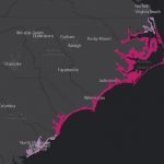
Figure 5. As of 11 am EDT Thursday, the NHC storm surge warning area covered a large swath of the coast of North and South Carolina. The warning extended well inland along the Pamlico and Albemarle sounds of North Carolina. Image credit: NHC.
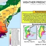
Florence rainfall forecast
Figure 4. Predicted 7-day rainfall amounts from Florence from 11 am EDt Thursday, September 13, 2018. Image credit: NOAA.
Figure 3. The 0Z Thursday, September 13, 2018 track forecasts by the operational European model for Florence (red line, adjusted by CFAN using a proprietary technique that accounts for storm movement since the time of the model run), along with the track of the average of the 50 members of the European model ensemble (heavy black line), and the track forecasts from the “high probability cluster” (grey lines)—the four European model ensemble members that have performed best with Florence thus far. These forecasts were very unified on Florence approaching the coast of North Carolina, then moving southwest along the coast and inland over South Carolina. Image credit: CFAN.
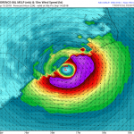
Figure 2. HWRF model winds and pressure forecast for 2 am EDT Friday, September 14, from the 6Z Thursday run of the model. The HWRF model was our top intensity model from 2017, and predicted that Florence would make landfall near the South Carolina/North Carolina border as a borderline Category 1/Category 2 hurricane with winds of 95 mph. Image credit: Levi Cowan, tropicaltidbits.com.
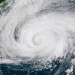
Florence satellite
Figure 1. GOES-16 image of Hurricane Florence at 10:30 am EDT September 13, 2018. Image credit: NOAA/RAMMB.
For more on this story go to: https://www.wunderground.com/cat6/Category-2-Florence-Nears-Landfall-North-Carolina-Catastrophic-Flooding-Expected


