90L in Western Caribbean slightly more organized; Development possible this weekend
 By Dr. Jeff Masters from Weather Underground
There has been a slight increase in organization over the past day to the area of disturbed weather (90L) associated with a broad surface low centered near the northeast coast of Belize in the western Caribbean. This system was spreading showers and thunderstorms over Cuba, Mexico’s Yucatan Peninsula, the Cayman Islands and Florida Straits on Wednesday afternoon. 90L was embedded in an unusually moist atmosphere (with precipitable water just under 2”), but the associated showers and thunderstorms were on the thin side and poorly organized, as seen on satellite loops. This activity will move slowly northward at about 5 mph through the central and eastern Gulf of Mexico over the next few days, where sea surface temperatures (SSTs) range from 25 – 28°C (77 – 82°F)—near the lower limit of 26.5°C (80°F) that is typically needed for a tropical depression form. The system will be moving over these marginally warm waters for several days, and has the potential to gradually acquire tropical characteristics and become a warm-cored tropical or subtropical depression during the weekend.Wind shear over the system was a high 25 – 30 knots on Wednesday, and was predicted to stay high through at least Friday, making development unlikely until this weekend.
The Madden-Julian Oscillation (MJO), a pattern of increased thunderstorm activity near the Equator that moves around the globe in 30 – 60 days, and which can increase the odds of tropical cyclone formation when it is strong and located in the proper location, is predicted to be in a location that favors tropical cyclone formation in the Gulf of Mexico and Western Caribbean during the coming week.
In a special 8 am EDT Wednesday Tropical Weather Outlook, The National Hurricane Center gave the system 2-day and 5-day odds of development of 0% and 60%, respectively. The first name on the Atlantic list of storms for 2018 is Alberto.
  |
| Figure 1. Predicted tracks of a potential tropical depression or tropical storm from the 0Z Wednesday European model ensemble forecast (left) and 0Z Wednesday GFS ensemble forecast (right). About 40% of the ensemble members of the European model, and 70% of the members of the GFS model, predicted that a depression would form by early next week. The purple dots show where the predicted storm is at tropical depression strength, and the blue dots, tropical storm strength. None of the ensemble members predicted that a hurricane-strength storm (light blue dots) would form. Image credit: cfanclimate.com. |
A Central American Gyre
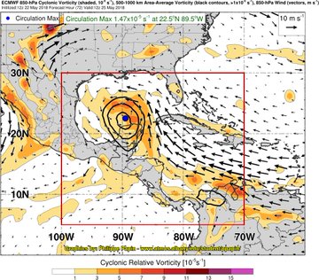
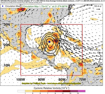
90L’s broad circulation, abundant moisture and origin location may qualify it to be classified as a Central American Gyre (CAG), as detailed by Philippe Papin in an excellent series of tweets on Tuesday evening (click on the tweet below to see his full chain of 9 tweets on the subject). Central American Gyres are common in May and June, and again in September – November. Last year’s Tropical Storm Cindy was born out of a CAG in mid-June, and four other named storms late the season also had their genesis from a CAG. The CAG that 90L is embedded in has an upper level trough on its east side, which is increasing precipitation on that side–over Cuba, the Cayman Islands and South Florida. About half of all CAGs end up spawning a tropical depression or subtropical depression; often an area of increased spin associated with a blow-up of thunderstorm activity on the northeast side of the large-scale CAG circulation will spiral into the center of the CAG, triggering development of a tropical depression. It will be interesting to follow 90L and see if that occurs.
Model predictions still very fuzzy
The 0Z Wednesday operational runs of our top three models for predicting tropical cyclone genesis–the European, GFS and UKMET models–all showed some weak development of 90L, but differed in the timing and location of development. The European model predicted that a tropical depression would form by Saturday in the central Gulf of Mexico, then make landfall by Sunday night over Louisiana. The 0Z and 6Z Wednesday operational runs of the GFS model showed development very close to Florida on Sunday morning, with the system moving northward into Georgia by Sunday night. The 0Z Wednesday run of the UKMET model predicted that development near the Florida Keys on Sunday, with the system tracking northwards a few hundred miles west of the west coast of Florida, making landfall in the Florida Panhandle on Tuesday.
About 40% of the 50 ensemble members of the 0Z Wednesday European model forecast and 70% of the 20 members of the 0Z Wednesday GFS forecast predicted that a tropical or subtropical depression would form over the eastern Gulf of Mexico by early next week. These solutions predominantly predicted a track that would result in landfall between Louisiana and the Florida Panhandle between Saturday and Monday. None of these ensemble forecasts predicted that a hurricane-strength storm would occur.
  |
| Figure 2. Predicted precipitation for the 7-day period ending at 8 am EDT Wednesday, May 30, 2018. Invest 90L is predicted to bring rainfall amounts 3 – 5 inches to much of the Southeast U.S. Image credit: National Weather Service. |
Heavy rains the main threat
Regardless of development, the counter-clockwise flow of air around this low-pressure system in combination with a very wet tropical airmass will funnel large amounts of tropical moisture over Cuba and the Southeast U.S., resulting in very heavy rains during the coming week. The latest guidance from the National Weather Service (Figure 2) shows a 3 – 5” of rain is expected over the next 7 days over much of the Southeast U.S. Much of the Southeast U.S. is abnormally dry or in moderate drought, though, which will make the region less prone to flooding than usual for this time of year.
The Weather Company’s primary journalistic mission is to report on breaking weather news, the environment and the importance of science to our lives. This story does not necessarily represent the position of our parent company, IBM.
IMAGE: GOES-East satellite image of 90L taken at 10:30 am EDT May 23, 2018. Image credit: NOAA/RAMMB.
For more on this story go to; https://www.wunderground.com/cat6/90l-western-caribbean-slightly-more-organized-development-possible-weekend


