Tropical Storm* [*HURRICANE] Michael headed into the Gulf of Mexico
 *NOTE: Since this story was written Michael is now a HURRICANE!
By Dr. Jeff Masters ·From Weather Underground
Tropical Storm* Michael is headed northward over the warm waters of the Western Caribbean, and is expected to make landfall along the U.S. Gulf Coast between Alabama and the Florida Panhandle on Wednesday, most likely as a Category 2 hurricane. An Air Force hurricane hunter airplane arrived in the storm Sunday afternoon found surface winds of 60 mph and a central pressure of 997 mb by the end of their flight.
Satellite images on Sunday afternoon showed that Michael was sloppily organized, with an elliptical low-level center of circulation that was partially exposed to view. The system did have an impressive area of very heavy thunderstorms, with cloud tops that were as cold as -80°C. Cloud tops this cold can only occur if the updrafts pushing them upwards are very vigorous. The thunderstorms were not well organized, though, with a clumpy appearance, although more low-level spiral banding was developing. Michael was under a moderately high 20 knots of wind shear, due to strong upper-level winds out of the west from an upper-level trough of low pressure. Michael was embedded in a moist atmosphere with a mid-level relative humidity of 70%, and was over very warm waters of 29.5°C (85°F). These warm waters extended quite deep, and had a very high heat content.
Michael was bringing heavy rains to western Cuba, as seen on Cuban radar. NHC was calling for total rainfall amounts of 3 – 7” over western Cuba, with isolated totals of 12”. Lower rainfall amounts of 2 – 4” were predicted for the Florida Keys and Mexico’s Yucatan Peninsula.
Michael is embedded on the north side of a large area of surface low pressure called a Central American Gyre, which is straddling Central America. The counter-clockwise flow of air around this low has brought a moist flow of Pacific air inland over Costa Rica, El Salvador, and Nicaragua, bringing 48-hour rainfall amounts in excess of 10” to portions of those nations. This low will continue to bring heavy rains to portions of the Pacific coasts of El Salvador, Nicaragua, Guatemala, and Honduras through Monday, bringing dangerous flash flooding and mudslides. Over 2700 people were in shelters in Costa Rica due to flooding, and over 1000 in Nicaragua.
[#TweetForScientists] Landfall point for #TD14 (future #Michael) is coupled to forward speed. As Rockies trough lifts northeastward, east coast ridge weakens and flow over GOM becomes more southwesterly. If Michael slower, this gives opportunity for right turn before landfall. pic.twitter.com/ttaNHt0Q1x
— Levi Cowan (@TropicalTidbits) October 7, 2018
Track forecast for Michael: Florida Panhandle at highest risk
There is fairly high model consensus on the general track of Michael, but some important details are yet to be resolved. Michael will be shuttled north to northeast between a summerlike ridge of high pressure along the U.S. East Coast and a seasonally strong trough across the West. The flow between the two features is pulling large amount of moisture across the Great Plains, where a corridor of heavy rain will drop 5” – 10” from Texas to Michigan early this week (a rainfall event that may be just as heavy and impactful as the rains from Michael).
The eastern ridge will be gradually weakening into midweek as the western trough moves into the heart of the country. Together, these features will pull Michael northward, then northeastward. With this steering, Michael will reach the central Gulf Coast by midweek and then head back off the Southeast or mid-Atlantic coast by late week; it’s possible that Michael will drop 1” – 3” of unwanted rain across parts of South and North Carolina that were inundated by Hurricane Florence last month. Similar amounts could fall from the mid-Atlantic toward southern New England, depending on exactly how Michael tracks.
Here’s the diagnosis from several of our top track models:
—The last several runs of the GFS model (though 12Z Sunday) brought Michael to the western Florida Panhandle coast on Wednesday, across the central Carolinas on Thursday, and off the mid-Atlantic coast by Thursday night.
—The experimental FV3-GFS model’s track is similar but a bit further to the northwest.
—Sunday’s 0Z and 12Z runs of the European model agreed on a western FL landfall, but not until Wednesday night or Thursday morning. The slower Euro solution also takes Michael on a more southerly inland track that would roll along or near the Carolina coast late Thursday into Friday and off the Outer Banks by late Friday.
—Sunday’s 0Z and 12Z UKMET tracks were similar to the Euro’s. The 12Z UKMET and Euro model runs were concerning, as they showed the potential for Michael to emerge over water off the coast of South Carolina. Michael thus has the potential to affect a large portion of the coast of South Carolina and North Carolina as a strong tropical storm or Catgeory 1 hurricane.
In general, the track solutions for the central Gulf Coast are close enough that they all fall comfortably within the NHC forecast cone, more so than usual for a prediction three days out. Michael’s greatest landfall impacts are likely to be along the Florida Panhandle coast, although residents of the Mississippi and Alabama coasts should remain on guard for now. Timing is a somewhat bigger uncertainty: Michael could make landfall as early as Wednesday morning (as predicted by NHC) or as late as Thursday morning. With this in mind, preparations should be completed on Monday wherever possible.
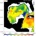
Oceanic heat content on 10/6/2018, Gulf of Mexico
Figure 1. Ocean Heat Content (OHC) levels in the Gulf of Mexico for October 6, 2018. Michael is predicted to pass over a cool eddy with low heat content on Monday night after it passes through the Yucatan Channel between Cuba and the Yucatan Peninsula. But on Tuesday, Michael’s center will pass just to the east of a warm Loop Current eddy with high heat content, and if the system is well organized when it passes over the warm eddy, rapid intensification is possible. Image credit: University of Miami Rosenstiel School of Marine and Atmospheric Science
Intensity forecast: a Cat 2 at landfall
The main impediment to intensification will be wind shear. An upper-level trough of low pressure was bringing 20 knots of shear to Michael Sunday afternoon. This trough is forecast to weaken to pull to the west, allowing shear to drop to 10 – 20 knots on Monday – Wednesday as the strongest upper-level winds arc around Michael’s north side. Shear of this magnitude and type should allow at least steady strengthening, and possibly rapid intensification. The 0Z Monday run of the SHIPS model gave a 23% chance that Michael would intensity into a 130 mph Category 4 hurricane by Wednesday night. However, the model’s most likely intensity estimate was for a Category 2 hurricane with 100 mph winds at that time. The 18Z Sunday run of our top intensity model from 2017, the HWRF model, predicted landfall on Wednesday morning as a Category 3 hurricane with 125 mph winds. Our other