Seabirds get caught up in Cyclone
 Seabirds get caught up in Post-Tropical Cyclone Hermine’s eye
BY MARIA GALLUCCI From Mashable
When hurricane-force winds are whipping violently over the ocean, the safest place for seabirds may be right in the eye of the storm.
Lease terns, royal terns, sooty terns and frigatebirds were spotted over Florida last Friday as Hermine — currently a post-tropical cyclone — made landfall over the Sunshine State.
Snapshots of weather radars showed flocks of birds trapped in Hermine’s eye, which likely provided a space of relative calm as the storm’s winds peaked at 80 miles per hour late last week.
Ryan Terrill, a bird watcher and doctoral candidate at Louisiana State University, said on Twitter that he spotted dozens of species of seabirds near Gainesville, Florida, on Sept. 1 and 2.
Terrill shared his findings on eBird, an online checklist and community data program run by the Cornell Lab of Ornithology and National Audubon Society.
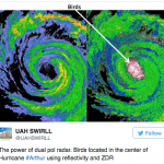
Bird and weather experts likened Hermine’s bird-catching winds to those of 2014’s Hurricane Arthur, which made landfall over North Carolina.
A radar grab from the Severe Weather Institute’s Radar and Lighting Laboratories in Alabama showed birds trapped in the eye of Arthur near Newport and Morehead, North Carolina.
Kenn Kaufman, a birding expert and field editor for the magazine Audubon, previously explained how birds get caught up in such storms:
The birds get into the end of the hurricane’s spiral and they move toward the eye of the hurricane. They may not necessarily do that in any organized way; more likely they’re out there in all this wild wind and when they chance into the calm of the eye they may make an effort to stay there and travel with it rather than fighting the winds again.
When the storm reaches land, some of them may start fighting the winds. Others may go with it and travel with the eye until the hurricane dissipates. The majority of seabirds, if they are not too weakened from having flown for so long without food, will probably find their way back to shore quickly. They have great powers of navigation.
Post-Tropical Cyclone Hermine isn’t projected to make landfall again as it continues its slow, erratic movements off the Atlantic coast, although the storm may still cause flooding and storm surge in the mid-Atlantic and southern New England states, the National Hurricane Center (NCH) said on Sunday.
NOTE: Since this story was writteb Hermine has now dissipated.
IMAGES:
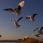
A flock of — you guessed it — seagulls.IMAGE: TOMOHIRO OHSUMI/GETTY IMAGES
Brad Panovich ✔@wxbrad
Birds trapped in the eye of #Hermine similar to previous systems like Arthur on the NC coast, seeking refuge there.
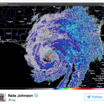
Nate Johnson ✔@nsj
Dual-pol radar detecting birds (birds!) in the eye of #Hermine. Happened with #Arthur, too. http://rtpi.org/hurricane-arthur/ …
UAH SWIRLL @UAHSWIRLL
The power of dual pol radar. Birds located in the center of Hurricane #Arthur using reflectivity and ZDR
For more on this story go to: http://mashable.com/2016/09/04/hurricane-hermine-seabirds/?utm_campaign=Feed%3A+Mashable+%28Mashable%29&utm_cid=Mash-Prod-RSS-Feedburner-All-Partial&utm_source=feedburner&utm_medium=feed#1c2vvcTBISqf