POTENTIAL TROPICAL CYCLONE TWENTY-SIX FORMS – CAYMAN IN PROJECTED PATH
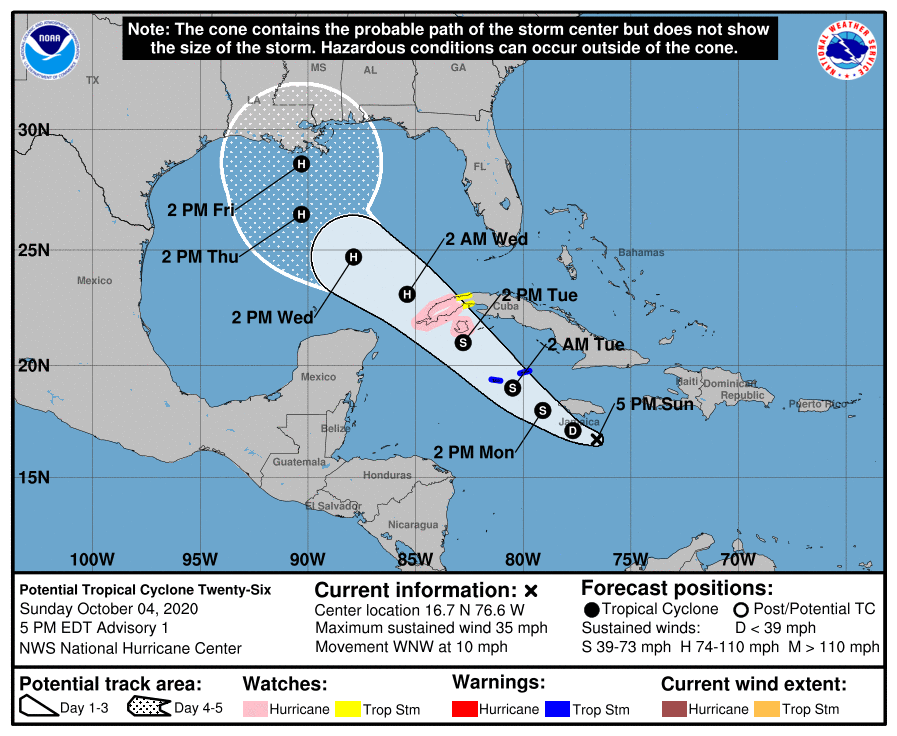
WARNINGS AND WATCHES ISSUED FOR THE CAYMAN ISLANDS AND WESTERN CUBA
Potential Tropical Cyclone Twenty-Six Discussion Number   1
NWS National Hurricane Center Miami FL
500 PM EDT Sun Oct 04 2020
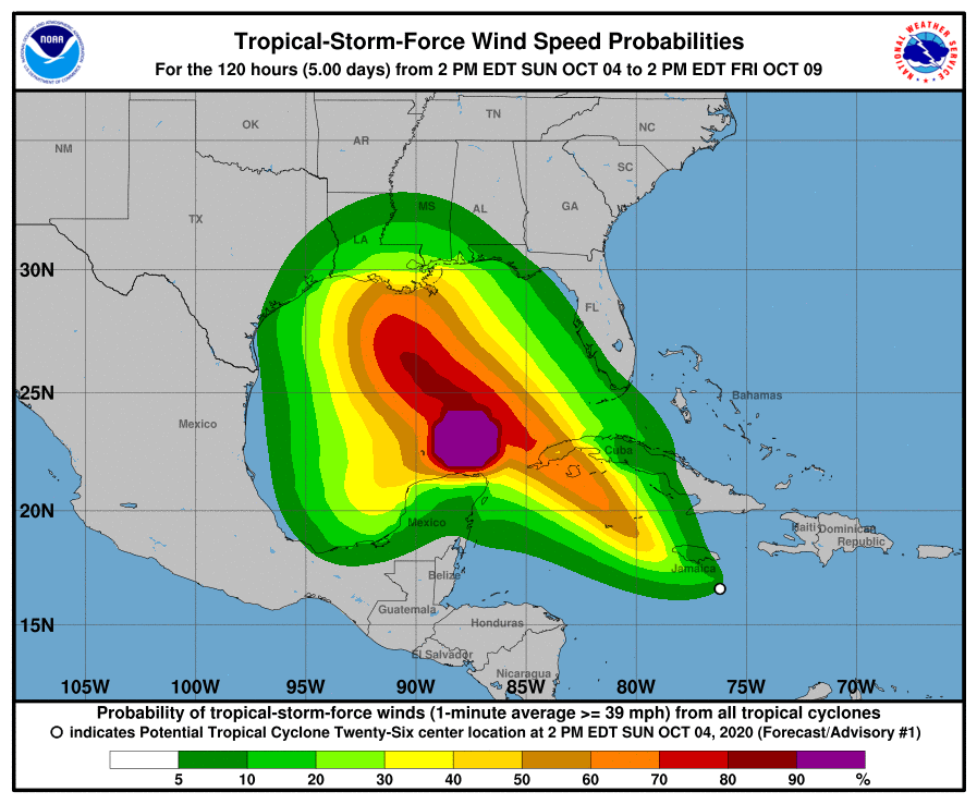
Visible satellite imagery and earlier scatterometer data indicated
that the circulation associated with the area of low pressure in the central Caribbean Sea has gradually become better defined.  The
associated deep convection does not yet have enough organization to
classify the system as a tropical depression, but there has been
some increase in convection just south of the estimated center.  The earlier ASCAT data revealed peak winds of around 30 kt over the
northeastern portion of the circulation, and that is the basis for
the initial intensity.  The disturbance is located over warm waters
and in a moist environment, but there is some modest northeasterly
shear over the system.  The global models indicate that the shear
will decrease overnight, and the oceanic and atmospheric environment is expected to quite favorable for both the development of a tropical cyclone and subsequent strengthening of the system over the northwestern Caribbean Sea during the next couple of days.  The intensity guidance is quite aggressive, but also assumes that the system already has a tropical cyclone structure.  Therefore, the NHC intensity forecast is a little below the intensity consensus during the first 24-48 hours, but does show the system at or near hurricane strength by the time is near western Cuba on Tuesday.  Environmental conditions are expected to remain favorable for strengthening over the southeastern Gulf of Mexico, and additional strengthening is predicted during that time.  Late in the period, conditions are forecast to become less conducive as the vertical wind shear increases and the system nears the cooler shelf waters of the northern Gulf of Mexico.

The disturbance is moving west-northwestward or 290/9 kt.  A mid-
to upper-level ridge over the western Atlantic is forecast to build
westward over the next few days, which should continue to steer the
system west-northwestward to northwestward over the northwestern
Caribbean Sea and southeastern Gulf of Mexico.  The forward speed
of the system is likely to increase in 48 to 72 hours while it
moves between the ridge and Tropical Storm Gamma to its southwest.
After 72 hours, the cyclone is forecast to slow down and turn
northward around the western portion of the ridge and a mid- to
upper-level trough over the south-central United States.  The track
guidance is in relatively good agreement during the first 48 to 72
hours, but there is increasing spread thereafter.  Users are
reminded that the average 4- and 5-day NHC track forecast errors
are about 160 to 200 miles at those time periods.

Key Messages:

1. Tropical storm conditions are expected in the Cayman Islands
beginning late Monday, and a Tropical Storm Warning is in
effect.

2. Dangerous storm surge and hurricane conditions are possible in
portions of western Cuba and the Isle of Youth by Tuesday
afternoon, and a Hurricane Watch is in effect.

3. Heavy rainfall will affect portions of Hispaniola, Jamaica, the
Cayman Islands, and western Cuba during the next few days and could
lead to life-threatening flash floods and mudslides.

4. The system is forecast to approach the northern Gulf Coast late
this week as a hurricane. While there is large uncertainty in the
track and intensity forecasts at these time ranges, there is a risk
of dangerous storm surge, wind, and rainfall hazards along the coast from Louisiana to the western Florida Panhandle. Residents in these
areas should monitor the progress of the system and check for
updates to the forecast during the week.

FORECAST POSITIONS AND MAX WINDS

INIT  04/2100Z 16.7N  76.6W   30 KT  35 MPH...POTENTIAL TROP CYCLONE
 12H  05/0600Z 17.1N  77.7W   30 KT  35 MPH...TROPICAL DEPRESSION
 24H  05/1800Z 18.0N  79.1W   35 KT  40 MPH
 36H  06/0600Z 19.0N  80.5W   45 KT  50 MPH
 48H  06/1800Z 21.0N  82.8W   60 KT  70 MPH
 60H  07/0600Z 23.1N  85.4W   70 KT  80 MPH
 72H  07/1800Z 24.7N  87.9W   80 KT  90 MPH
 96H  08/1800Z 26.5N  90.3W   85 KT 100 MPH
120H  09/1800Z 28.6N  90.3W   85 KT 100 MPH

$$
Forecaster Brown


