NYC when farmland
 Incredible photos of New York City when it was covered in farmland
By Leanna Garfield From Business Insider
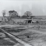
The Brennan farmhouse, at 84th and Broadway, 1879.Collection of The New-York Historical Society
Most New Yorkers today are living on what was once farmland.
As early as the 17th century, before Manhattan formed its famous street grid, the island contained farms in neighborhoods from Midtown to the Upper West Side.
The Museum of the City of New York’s online collection reveals what the city looked like at the time. The series, “The Greatest Grid,” features illustrations and photos of New York City’s former rolling hills, which were later demolished to create a flat streetscape.
Take a look at the city’s transformation:
The Bowery is the oldest thoroughfare on the island of Manhattan. When the Dutch settled there in 1654, they named the path Bouwerij — an old Dutch word for “farm” — because it connected cattle farms and estates on the outskirts to (what is today) Wall Street.
NYPL Digital Gallery
Source: The Encyclopedia of New York City
At the time, New York City (then known as New Amsterdam) featured rolling hills, forests, boulders, farms, and spaced-out homes. This 1776 illustration is of present-day University Heights in the Bronx.


A view of the attack against Fort Washington and rebel redoubts near New York on November 16, 1776, by the British and Hessian brigades, by Thomas Davies.The New York Public Library
Source: New York Public Library
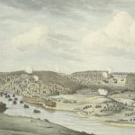
This 1862 illustration depicts a triangular farm on Manhattan’s Upper West Side during the Civil War. High property taxes discouraged landowners from building on their lots, and the area would not see full-scale development until the 1880s.
The junction of Broadway and Eighth avenues in 1861. Lithograph by George Hayward for D.T. Valentine’s Manual, 1862.The Museum of the City of New York
Source: The Museum of the City of New York
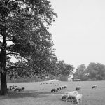
Sheep grazed on west Central Park’s Sheep Meadow from the 1860s until 1934, when they were moved to Brooklyn’s Prospect Park and later to a farm in the Catskill Mountains.
Pierre Martel, Central Park, 1864. Lithograph published by H. Geissler.The Museum of the City of New York
Source: Modern Farmer
The sheep’s owners relocated them because they feared that impoverished New Yorkers would eat the animals. City officials also wanted to build through-roads and the Tavern on the Green restaurant there.
Central Park’s Sheep Meadow, early 1900s.The Library of Congress
Source: NYC Travel Guide
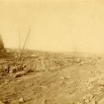
Beginning in the mid-19th century, Manhattan started demolishing the area’s hills — and thus farmland and some farmhouses — to make way for the city’s level thoroughfares. This 1869 photo shows a team of laborers excavating through a hillside to extend Eighth Avenue north.
Regulating and grading Eighth Avenue, looking north from 106th Street, circa 1869.Collection of The New-York Historical Society
Source: The Museum of the City of New York
“The time will come when New York will be built up, when all the grading and filling will be done, and when the picturesquely varied, rocky formations of the Island will have been converted into formations for rows of monotonous straight streets, and piles of erect buildings,” Frederick Law Olmsted, an NYC landscape architect, wrote at the time.
A view of the Brevoort Estate and Vicinity Between 54th and 55th streets, near First Avenue. Lithograph by Major & Knapp for D.T. Valentine’s Manual, 1866.The Museum of the City of New York
Source: The Museum of the City of New York
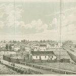
Patrick and Mary Brennan’s farmhouse, pictured below in 1879, lasted until about 1900. Edgar Allan Poe rented a room there, where he most likely wrote “The Raven.”
The Brennan farmhouse, at 84th and Broadway, 1879.Collection of The New-York Historical Society
Source: The Museum of the City of New York
T
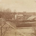
This photo was taken in 1882 from the roof of a mansion that belonged to George Ehret, a successful brewer and one of the first wealthy New Yorkers to move to Prospect Hill (now Carnegie Hill).
From the photographic series from the roof of George Ehret’s home at Park Avenue and 94th Street, 1882-83, by Peter Baab.Peter Baab/Museum of the City of New York
Source: The Museum of the City of New York
The photographer Peter Baab captured what he called the “march of improvement.” New row houses and mansions began to overrun the old factories, squatter homes, and farmhouses that once dominated the Upper East Side.
From the photographic series from the roof of George Ehret’s home at Park Avenue and 94th Street, 1882-83, by Peter Baab.Peter Baab/Museum of the City of New York
Source: The Museum of the City of New York
In the late 19th century, the city pushed to urbanize, and urban livestock — including hogs and dairy cows — were seen as a threat to the image and highbrow future of New York. According to CityLab, many members of Manhattan’s elite bought (or took) the city’s farmland, often owned by those of lower status, during this period.
Lenox Farm buildings, 1885.Museum of the City of New York
Source: CityLab
Irish pig farmers and German gardeners, as well as the African-American settlement of Seneca Village, worked and lived on the land that’s known today as Central Park. Most of their homes were destroyed in the 1860s to create the park.
Workers start the extension of New York’s Eastern Parkway in Brooklyn, 1896.NYC Parks
New York’s wealthy mostly funded the city’s parks and public spaces, in hopes of creating places where upper-class women could stroll without coming into contact with people of lower status, according to historians.
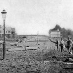
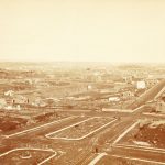
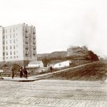
In this photo from 1890, 94th Street cuts through a hill next to a farmhouse.
The houses of Riverside Drive and 94th Street, looking west from 94th Street, June 1890.Museum of the City of New York
The newly graded streets attracted residents to upper parts of Manhattan. Within two decades, apartment buildings replaced the farmhouses in this 1898 photo.
A view of the southwest corner of Amsterdam Avenue and 124th Street, November 16, 1898, by James Reuel Smith.Collection of The New-York Historical Society
New York’s street grid became denser throughout the early 20th century. Though the grid was great for housing, city commissioners soon realized the master plan — and high land values — deprived residents of space and sunlight.
Manhattan’s tenement row, demolition in progress, circa 1934-1938.NYPL
The city moved toward a more modern urban plan called superblocks, which required demolishing tenement buildings and constructing larger apartment buildings with spacious green areas in between.
But New York City will most likely never be as grassy as it used to be.
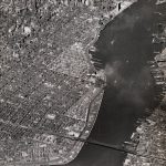
An aerial view of housing superblocks on the Lower East Side, April 30, 1952.Museum of the City of New York


