‘Extraordinary’: Iota becomes second category 4 hurricane to strike Central America in past two weeks
By Jeff Masters, Ph.D From YALE Climate Connections
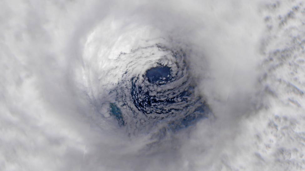
Hurricane Iota moved ashore Nov. 16 just 15 miles south of the location where Hurricane Eta made landfall Nov. 3.
Hurricane Iota roared ashore in northern Nicaragua as a high-end category 4 storm with 155 mph winds and a central pressure of 920 mb at 10:40 p.m. EST November 16. Iota is the strongest Atlantic landfalling hurricane so late in the year. The previous record was held by the 1932 Cuba Hurricane, which made landfall on Little Cayman Island with 155 mph winds on November 9, 1932.
Iota made landfall 30 miles south of Puerto Cabezas (population 40,000), just 15 miles south of where Hurricane Eta made landfall as a category 4 storm with 140 mph winds on November 3. In records going back to 1851, it is unprecedented for two Atlantic category 4 hurricanes to make landfall so close together, just two weeks apart. That they did so in November, when category 4 hurricanes are rare, is truly extraordinary. Only six category 4 or stronger hurricanes have ever been recorded in November or December, Eta and Iota in the past two weeks. Here is the very short list of these late-season hurricanes, sorted by highest lifetime wind speed:
Cuba Hurricane (175 mph; Nov. 6, 1932);
Iota (160 mph; Nov. 16, 2020);
Lenny (155 mph; Nov. 17, 1999);
Eta (150 mph; Nov. 3, 2020);
Paloma (145 mph; Nov. 8, 2008); and
Michelle (140 mph; Nov. 4, 2001)

Destructive flooding occurring in Nicaragua and Honduras
Torrential rains from Iota are causing widespread damaging flooding in Nicaragua and Honduras, including on the Bocay and Coco rivers in northern Nicaragua, and the Aguan, Iyas, and Tocoa rivers in northern Honduras.

Iota is expected to dump catastrophic rains of 10-20 inches, with isolated amounts of up to 30 inches, across a large region of Central America, with northern portions of Nicaragua, Honduras, and Guatemala at highest risk of devastating flooding. These are the same regions still recovering from catastrophic Hurricane Eta, which brought rains of more than 20 inches to portions of this region during the first week of November.
On Monday, Colombian President Iván Duque said that Iota damaged much of the infrastructure of the Colombian island of Providencia (population 5,000), about 145 miles east of Nicaragua’s coast, killing one person. Iota’s storm surge tore up huge blocks of pavement on ocean-facing roads on Providencia and nearby San Andres Island (see Tweet).
At 10 p.m. EST Monday, the Puerto Cabezas, Nicaragua, airport reported sustained winds of 70 mph, with a gust of 103 mph, and Iota’s winds tore off the city’s makeshift hospital, Reuters reported. The area’s primary New Dawn Hospital has been unsafe to use since Hurricane Eta, according to 100% Noticias El Canal

Iota rapidly weakening over Nicaragua
At 1 p.m. EST Tuesday, Iota was 105 miles east of the Honduras capital city of Tegucigalpa, headed west at 12 mph. Iota at that point was a tropical storm with top winds of 65 mph, and a central pressure of 988 mb.
Satellite imagery early Tuesday afternoon showed Iota was still well-organized, with a large area of heavy thunderstorms lashing Nicaragua, Honduras, El Salvador, Belize, Mexico, Guatemala, Panama, and Costa Rica.
Iota will move westward over the high terrain of Nicaragua and Honduras through Tuesday night, when it is predicted to weaken to a tropical depression. By Wednesday morning, Iota is expected to become post-tropical over El Salvador. Heavy rains from the remnant circulation of Iota still will continue over northern portions of Central America and southern Mexico through Thursday.

A tropical disturbance near Panama may develop late this week
Recent runs of the GFS and European models have consistently predicted that an area of low pressure capable of developing into a tropical storm will form late this week over the southwestern Caribbean Sea, off the coast of Panama. However, the models were less certain about development of this disturbance in their Tuesday morning runs than they were in their Monday runs.
Conditions for development will be favorable, with moderate wind shear of 10-20 knots, warm sea surface temperatures of 29 degrees Celsius (84°F), and a moist atmosphere. Steering currents favor a westerly to west-southwesterly motion at 5-10 mph, putting Costa Rica and Panama at most risk of experiencing a landfall. None of the 51 members of the 0Z Tuesday European model ensemble forecast, and none of the 31 members of the 12Z Tuesday GFS model ensemble forecast, predicted that the new disturbance would be a landfall threat for northern Nicaragua, where Iota and Eta hit.
The most recent model forecasts show the disturbance developing very close to the coast of Panama by Friday or Saturday, then potentially crossing into the eastern Pacific Ocean, bringing heavy rains to the Pacific coast of Central America early next week. The next name on the Atlantic list of storms is Kappa, the 10th letter of the Greek alphabet.
If Kappa does form, the storm is unlikely to have sufficient time over water to develop into a hurricane, and it would be a relatively small tropical storm. However, Kappa could be a significant heavy rain threat for southern Nicaragua, Costa Rica, and Panama, with 4-8 inches of rain possible Friday through Sunday.
October 2020 was fourth-warmest October on record, NOAA and NASA report
In a 1 p.m. EST Tuesday tropical weather outlook, the National Hurricane Center gave 2-day and 5-days odds of development of 0% and 30%, respectively, to this future disturbance.
Helping out the victims of the hurricanes of 2020
For those wanting to help out with charitable donations for the hurricanes of 2020, a reporter I’ve been working with in Honduras, Jeff Ernst, said in an email, “I think World Vision is doing a good job of responding to the disaster and I know several people in the local administration here and think highly of them.” I used World Vision’s Hurricane Eta donation link to help out in Honduras, and have also donated to Hurriup.org, the disaster relief charity founded by members of the Weather Underground user community. For those living in Miami, Mayor Suarez tweeted out locations where donated goods can be left for Honduras relief.
For more on this story go to: YALE Climate Connections