Desert on fire
 By Namak Khoshnaw and Daniel Silas Adamson From BBC
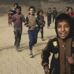
The families surrounded by smoke and flames visible from space
Early in summer 2016, the so-called Islamic State set fire to one of Iraq’s largest oil fields.
It has taken Iraqi firefighters 10 months to put the flames out.
The smoke has poisoned the air, the land, and the water across a vast region of Northern Iraq.
Photos from the charity Oxfam reveal how difficult life has been for the people of Qayyarah, since the Islamic State group fled their town.
Families
Ali Hassan, his wife Fatima Mahmoud and their three children have been living next to a burning oil well.
Black smoke from the blaze filled their home.

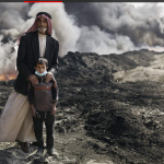
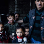
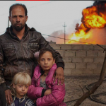
Fatima said she was always cleaning, but the dirt just kept coming.
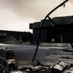
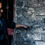
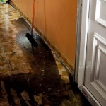
Mahmoud Ali’s house was ruined by an oil fire that raged for two months outside his front door.
The walls are blackened and the floors thick with tar.
Mahmoud used to be a policeman before the IS group took control of Qayyarah.
He was displaced by the conflict and recently returned to find his home in ruins.
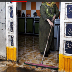
Oxfam has been trying to make Qayyarah’s water supply safe to drink with deliveries of chlorine to the local treatment plants.
The charity’s staff there have been told by local people that up to 60 homes were completely burned in the oil fires.
But many more became uninhabitable because of the oil bubbling in and around them.
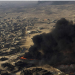
From above
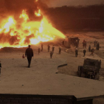
In summer 2016, with the Iraqi army and Kurdish forces advancing west towards Qayyarah, fighters from so-called Islamic State rigged the wellheads with explosives.
The jihadists then shot at them from the roofs of nearby houses. Their hope was that the smoke would provide cover against airstrikes.
As the fires took hold, the wellheads collapsed into craters of burning oil that darkened the sky and sent toxic fumes into the villages beyond.
Control of Northern Iraq
End of May 2016
Control area information:
Conflict Monitor by IHS Markit
Satellite imagery:
Google, Nasa, Unitar-Unosat
(Cnes\/Spot Image, DigitalGlobe,
Landsat\/Copernicus, Data SIO, NOAA, US Navy, NGA, Gebco)
Control area information:
Conflict Monitor by IHS Markit
Satellite imagery:
Google, Nasa, Unitar-Unosat
(Cnes/Spot Image, DigitalGlobe,
Landsat/Copernicus, Data SIO, NOAA, US Navy, NGA, Gebco)
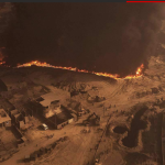
Nasa’s Landsat 8 caught the first signs of trouble in June 2016
The satellite spotted a cloud of dark smoke blooming in the desert of Northern Iraq – about 60km (37.5 miles) south of Mosul.
By October, around 20 oil wells were on fire.
As recently as 25 February 2017, Nasa’s heat-detecting satellites appeared to show several distinct clusters of fires.
Now, in early April, the last of the wells around Qayyarah have finally been extinguished.
But the landscape remains heavily polluted and the clean-up operation is expected to take many months.
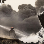
Extinguishing an oil fire is a major technical undertaking, even in peacetime.
But the Iraqi government fought these fires on the edge of a war zone, at a time when most of its resources are still deployed in the battle against the so-called Islamic State.
Before Iraqi engineers could even approach these flames, they had to clear the surrounding land of hundreds of improvised explosive devices planted by IS.
No-one knows how many IEDs remain.
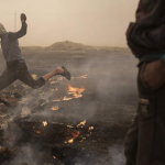
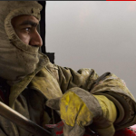
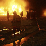
Firefighters
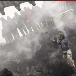
The men battling to put out the fires used to work in the oil fields that underpinned Qayyarah’s economy.
But in the past year they have been working eight-hour shifts on the edge of these apocalyptic craters, withstanding intense heat and breathing air that stinks of burning tar.
Close to the edge of craters, pockets of oil and gas ignited without warning.
Excavators dumped load after load of damp sand on to the flames, while men with high-pressure water hoses struggled to keep the machinery cool enough to function.
On some days in Qayyarah the air was so thick with black smoke that it completely blocked out the sun.
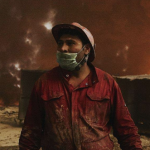
Fumes
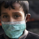
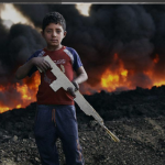
In the acrid smoke, children playing out of doors began to struggle for breath and scratch at rashes on their skin.
Their eyes reddened and their lungs burned from smoke that contained carbon dioxide, acidic aerosols, and toxic metals such as lead and mercury.
A film of stinging, abrasive grease settled on people’s clothes and hair.
Boys played on the smouldering remains of extinguished fires, or threw stones into lakes of crude oil that pooled on the surface.
When they cleaned their teeth, they spat blackened toothpaste into the sink.
The public health crisis was exacerbated in October last year when the IS group set fire to a sulphur factory in Al-Mishraq, just north of Qayyarah.
A cloud of sulphur dioxide and sulphuric acid spread across Iraq, reaching south as far as Baghdad and northwest into Turkey and Syria.
A UN report found that over a period of just three days in that month, when the sulphur fire was still burning, more than 1000 people were treated for respiratory complaints and skin conditions caused by smoke from the factory fire and oil wells.
Also in October, a doctor in the nearby village of Haji Ali, Basima Obnar Mohammed, told Oxfam that she was treating around 20 children every day for breathing difficulties and gastritis caused by drinking polluted water.
“They need steroid cream for their skin,” she told the charity, “but we have a shortage of medicine.”
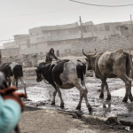
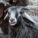
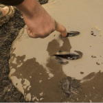
In the polluted air, the sheep on which many families in Qayyarah depend became black, sick and starving.
Soot settled on the animals’ grazing land and sank into the water they drank.
Full circle – a 360 view
See the smoke and flames in Qayyarah up close in this video from January 2017.
Use your mouse, trackpad or arrow buttons to look left, right, up and down.
It will not work in the Safari web browser – and is best experienced on the YouTube mobile app.
Some names have been changed to protect identities.
For more on this story and video go to: http://www.bbc.co.uk/news/resources/idt-sh/desert_on_fire


