Deadly fires on rampage in Southern California; Subtropical Storm Melissa forms off Northeast U.S. Coast
By Bob Henson From Weather Underground
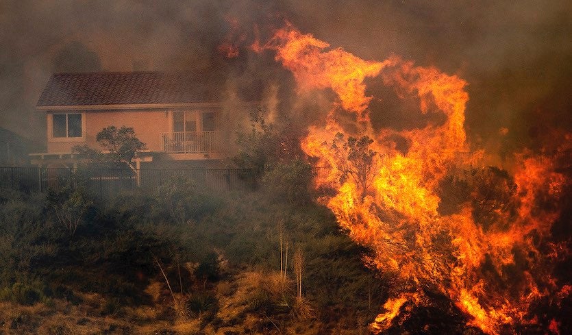
A major fire emergency—the highest possible alert level—has been declared by the Los Angeles Fire Department for the Saddleridge Fire, which was raging uncontained across 4700 acres at the north end of the San Fernando Valley on Friday afternoon. More than 23,000 homes have been evacuated, and Interstates 210 and 5 have been closed.
Meanwhile, the Sandalwood Fire consumed at least 73 manufactured homes on Thursday in Calimesa, about 65 miles east of Los Angeles. At least one death was reported in the blaze.
Extremely critical fire weather is predicted through Friday for areas in and near the coastal mountains from Los Angeles and San Diego. See the frequently updated article atweather.com for the latest on these fires.
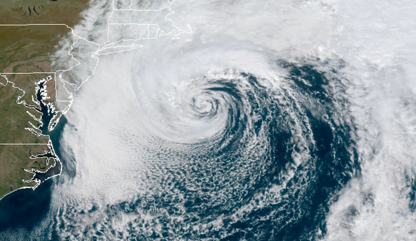
Melissa takes shape off U.S. East Coast
A slow-moving coastal storm with 65 mph winds centered about 200 miles southeast of southeast Massachusetts transitioned into Subtropical Storm Melissa at 11 am EDT Friday. Melissa’s formation brings the 2019 tally of Atlantic tropical cyclone activity to 13 named storms, 5 hurricanes, 3 major hurricanes, and an ACE index of 117. An average seasontypically has 12 named storms, 5 hurricane, 2 major hurricanes, and an ACE index of 89 by October 11.
Melissa has the hallmarks of a classic late-season subtropical storm. It has a warm core, like a tropical storm does, but the structure will be growing more asymmetric, as depicted in phase-space diagrams from Florida State University. Melissa looks much more like a midlatitude storm on satellite, with the characteristic comma shape and the most intense showers and thunderstorms (convection) wrapped around its north and west sides.
Unusually warm sea surface temperatures are giving Melissa a boost. The storm is sitting close to the edge of the Gulf Stream, and sea surface temperatures on Melissa’s south side are about 26°C (79°F). This is close to 2°C above average for this time of year, and near the benchmark minimum for tropical development.
Melissa is tucked within a weak upper-level low, instead of sitting beneath a ridge—another factor that has pushed toward subtropical rather than tropical development. Melissa will drift only slowly away from the coast until Saturday, when it will accelerate eastward under the influence of a much stronger upper-level trough, the same one that’s pushing a powerful cold front into the eastern U.S. The storm is predicted by NHC to steadily weaken over the next couple of days, with winds dropping below tropical-storm strength (39 mph) by Sunday.
Impacts from Melissa
The biggest U.S. impact from Melissa will be coastal flooding—the result of prolonged onshore fetch between Melissa and a zone of high pressure over far eastern Canada. Moderate coastal flooding is expected along the Atlantic coast from Virginia to western Long Island, including Delaware Bay and parts of Chesapeake Bay. Pockets of major coastal flooding are possible. High water levels will extend into the weekend over multiple tidal cycles, which will allow water to pile up in bays and estuaries well inland.
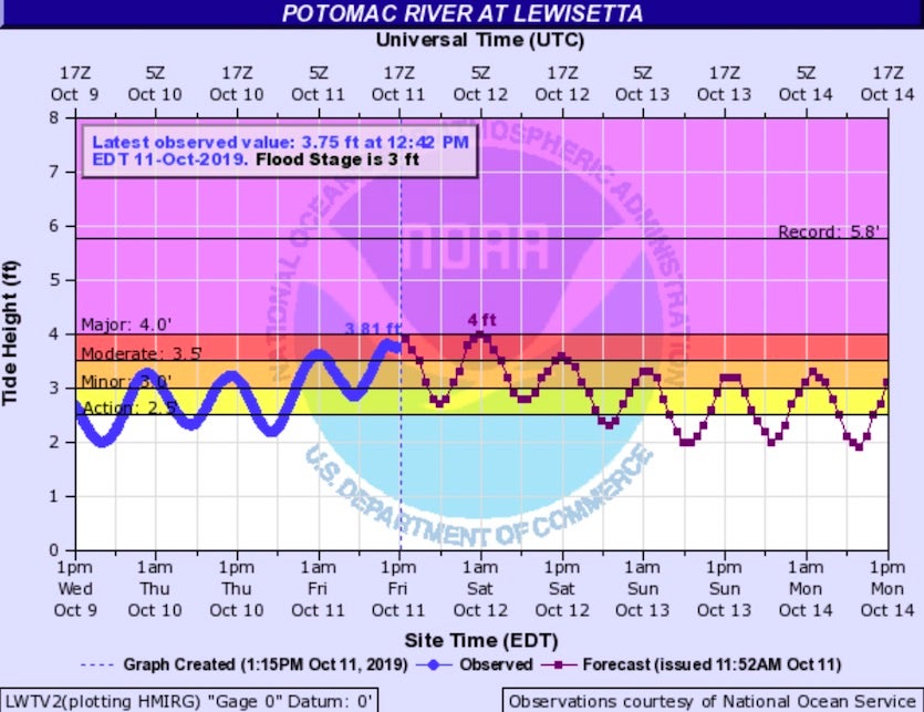
The following values of storm surge (high water associated with Melissa, on top of astronomical tides) were being reported around 12:30 pm EDT Friday.
Money Point, VA: 3.1’
Wachapreague, VA: 3.2’
Ocean City Inlet, MD: 2.8’
Atlantic City, NJ: 2.7’
Sandy Hook, NJ: 3.1’
The Battery, NY: 2.7’
Montauk, NY: 2.3’
Woods Hole, MA: 1.7’
Melissa will produce widespread beach erosion and rip currents, with surf of up to 9 feet possible on Friday. Wave heights at buoy 44011, about 200 miles east of Hyannis, Massachusetts, were averaging 20 to 25 feet on Friday morning.
Wind gusts brought down trees, branches, and some power lines across Cape Cod, Massachusetts and nearby islands on Thursday, and gusts to 50 mph are possible there today. Dry continental air has cut back on the expected rainfall amounts in southeast Massachusetts, although some 2-3” totals were reported near Harwich and Chatham. Another 1”-2” is possible there, with lower totals further inland.
For more on Typhoon Hagibis, which is expected to strike near Tokyo as a large and damaging Category 1 storm on Saturday, see the post from earlier today by Jeff Masters.
Jeff Masters contributed to this post.
For more on this story go to: https://www.wunderground.com/cat6/Deadly-Fires-Rampage-Southern-California-Subtropical-Storm-Melissa-Forms-Northeast-US-Coast


