Antique Maps: Grand and Lesser Caymans surveyed by British Admiralty
From Rare Maps
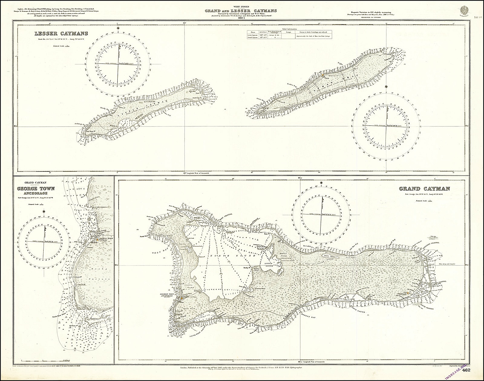
Description
“[T]he first chart of all 3 [Cayman] islands” – David Wells, A Brief History of the Cayman Islands
A rare separately issued chart of the Cayman Islands, first published by the British Admiralty in 1880. The image includes a map of the two Lesser Caymans, a separate map of the Grand Cayman, and an inset of the George Town anchorage area. The charts show extensive navigational information, including soundings, tidal information, reef channels, rip currents, and more.
Originally named Las Tortugas, and later renamed to reflect another species of reptile living on the island, the Caymans are one of the few places Columbus can be truly credited with discovering. Under British control since 1670, they are now a British Overseas Territory. The low-lying islands are a popular destination today, in part due to their Caribbean landscapes and crystal seas.
The Cayman Islands were increasingly isolated during the second half of the 19th century after a series of hurricanes and conflicts with the Spanish. This news coverage lead to a surge in public interest leading to the HMS Sparrowhawk sailing for the islands in 1880-1881. The crew of the Sparrowhawk produced the first navigational map of all three islands, seen here. In particular, they greatly increased the knowledge about the Lesser Caymans, Cayman Brac and Little Cayman. As such, the highest point on Little Cayman retains the name Sparrowhawk Hill, as it was labeled on the map.
The British Admiralty published some of the best available sea charts into the modern era. This can be seen in the extensive soundings and other notes that have been made. The navigability of the lagoon, back barrier areas, and the open ocean are well explained through this map to an extent where this chart could likely be used in the present day. Further, the signals from lighthouses, buoys and beacons are all explained in the upper right corner. Inland areas are equally well documented. Some notes are made on topography, and all major roads and buildings are annotated. George Town is still a small coastal town centered around Fort George. The chart goes so far as to document a cotton tree which has grown to a height of 50 feet, sketching it on the map.
In all, this is a good quality map of the Cayman Islands, remarkable for its visual simplicity while conveying extensive information.
For more on this story go to; https://www.raremaps.com/gallery/detail/67234/grand-and-lesser-caymans-surveyed-by-lieutenants-a-carpente-british-admiralty


