Revived Kirk heading for Lesser Antilles; Japan in Trami’s Sights
 By Bob Henson From Weather Underground
Tropical storm watches and warnings are in place across several eastern Caribbean islands ahead of strengthening Tropical Storm Kirk. As of 2 pm EDT Wednesday, Kirk’s top sustained winds were up to 60 mph. Kirk was located about 300 miles east of Barbados, moving just north of due west at a steady clip of 18 mph. Tropical storm warnings for Kirk were in effect for Barbados, St. Lucia, Dominica, Martinique, and Guadeloupe, with a tropical storm watch for St. Vincent and the Grenadines.
After forming on Saturday, fast-moving Kirk fell prey to strong wind shear and lost its closed circulation by Tuesday morning, when it was downgraded to a tropical wave by the National Hurricane Center. Strong winds remained on Kirk’s north side, though, and thunderstorms (convection) that had been racing to keep up with Kirk’s remnants began to consolidate around the center by Wednesday night. At the same time, surface wind data from the ASCAT scatterometer revealed that Kirk’s remnants again had a closed circulation, and NHC reinstituted advisories on Tropical Storm Kirk at 5 am EDT Wednesday. A reconaissance flight on Wednesday found top flight-level winds of 70 mph, and the Surface Frequency Microwave Radiometer (SFMR) showed near-surface winds of 59 mph, with a center that remainssomewhat elongated.


 Andy Hazelton@AndyHazelton
An AMSR2 microwave satellite of #Kirk from about an hour ago shows a mid-level eye (seen in the 89 GHz/ice scattering frequency). Not as pronounced at low/mid levels (the 36 GHz/warm rain frequency), perhaps due to tilt, but lines up nicely with the warm core the plane found.
Kirk’s structure improved on Wednesday morning, with a growing convective core and improving outflow at upper levels. Kirk is traveling over warm waters (sea surface temperatures around 29°C or 84°F) that extend to some depth, and wind shear is less than 10 knots, so Kirk might intensify a bit more and approach (or perhaps reach) hurricane strength by Wednesday night or Thursday. Kirk has only a brief window of time for intensification, though, as it will soon encounter the wall of wind shear that’s kept the Caribbean free of tropical cyclones in recent weeks. Satellite imagery early Wednesday afternoon showed early signs of the increasing shear to come. The 12Z Wednesday run of the SHIPS model projected that Kirk will encounter wind shear of greater than 30 knots (35 mph) from Thursday into the weekend. The strong shear will likely induce a weakening trend before Kirk reaches the Lesser Antilles, and further weakening can be expected afterward. The NHC predicts that Kirk will again be a remnant low by the time it reaches the central Caribbean on Sunday.
About 20% of the European ensemble members, and roughly half of the GFS ensemble members, show the potential for tropical cyclone development in the western Caribbean about 6 – 8 days from now. This would likely be separate from Kirk’s remnants, though, and continued wind shear in the northwest Caribbean may inhibit any such development.
 |
| Figure 1. WU depiction of radar-estimated rainfall from 98L as of 7:13 am EDT September 26, 2018. Rainfall amounts generally less than an inch fell across eastern North Carolina, with a few areas of 2+”. |
98L moving away from North Carolina
After dumping rainfall amounts of mostly less than an inch over portions of eastern North Carolina overnight, tropical disturbance 98L, which was located about 100 miles southeast of Cape Hatteras, NC at 8 am Wednesday morning, was headed northeast, out to sea. Rains of that magnitude won’t do much to much aggravate river flooding over the regions still recovering from Hurricane Florence’s floods, perhaps slightly slowing the fall of the rivers from peak flood stage. Satellite loops on Wednesday morning showed that 98L had plenty of dry air on its west side, and radar data showed the system’s heavy rain showers were well offshore. This disturbance is not likely to bring further rains to the coast. A more significant rain threat for the region comes on Thursday, when a cold front accompanied by showers, thunderstorms, and the threat of severe thunderstorms will bring widespread 2-day rainfall amounts of 1 – 3” to southern North Carolina.
With wind shear rising and dry air still hampering development, 98L is not expected to develop before merging with a frontal system on Thursday. In its Tropical Weather Outlook issued at 2 pm EDT Wednesday, the National Hurricane Center gave 98L 2-day and 5-day odds of development of near 0%.
Coming soon: The return of Leslie
The post-tropical cyclone that was once Subtropical Storm Leslie is now an elongated feature along a strong cold front in the central North Atlantic, but there is much more ahead for this system. Long-range models agree that part of the upper-level energy powering this front will help transform the post-tropical Leslie into an intense non-tropical storm with hurricane-force winds.


NWS OPC1445Z GOES16 visible satellite image of what was once #Leslie, now as a powerful extra-tropical low, expected to develop to #hurricane force #winds over the next 12 hours.
Eventually, Leslie will get cut off from the jet stream and drift southward over warmer waters, where it will likely again become a tropical or subtropical storm. In its 2 pm EDT tropical weather outlook on Wednesday, NHC gave 40 percent odds that Leslie would redevelop as a tropical or subtropical cyclone by Friday, and impressive 90 percent odds by Monday.
We may be dealing with Leslie for a long while to come. Both the European and GFS models from 00Z Wednesday keep a revived Leslie spinning over unusually warm waters between 30°N and 40°N throughout next week.
 Wednesday, September 26, 2018") |
| Figure 2. Natural-color visible wavelength image of Hurricane Rosa at 1620Z (12:20 pm EDT) Wednesday, September 26, 2018. Image credit: tropicaltidbits.com. |
Rosa vaults to hurricane strength in Northeast Pacific
The tenth hurricane of the busy Northeast Pacific season of 2018 is Rosa, which is rapidly strengthening well offshore about 500 miles south-southwest of Cabo San Lucas. With top sustained winds of 75 mph as of 11 am EDT Wednesday, Rosa is feeding on very warm waters (SSTs of around 29°C or 84°F) and a moist surrounding atmosphere (mid-level relative humidity around 75%) amid moderate wind shear of 10 – 15 knots. Wind shear will drop below 10 knots by Wednesday night, and Rosa has a good chance of becoming a Category 2 or 3 hurricane by Thursday. In classic Northeast Pacific fashion, Rosa should begin to weaken as it moves toward cooler waters this weekend.
Rosa could affect U.S. weather next week as it approaches Baja California. Models indicate a large slug of rich moisture will shoot into the Southwest U.S. around Monday. Some of this moisture may get all the way to the Corn Belt by midweek, where it could help stoke yet another round of heavy rains from Minnesota to Michigan.
 Wednesday, September 26, 2018") |
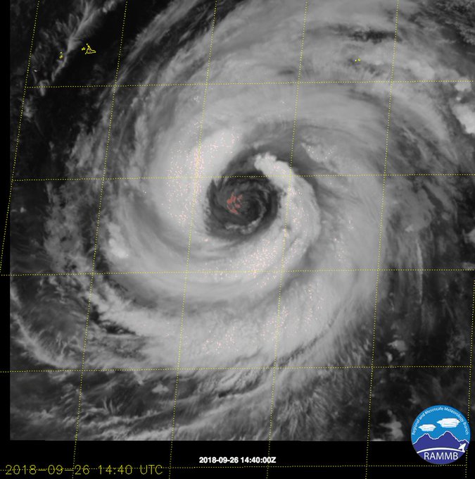
| Figure 3. VIIRS day/night satellite image of Typhoon Trami at 0429Z (12:29 am EDT) Wednesday, September 26, 2018. Image credit: RAMMB/CSU/CIRA. |
Trami on track for potential damaging winds and torrential rains in Japan
After significant weakening over the last day or so, Typhoon Trami will likely restrengthen over the next couple of days before it sweeps across Japan this weekend, posing one of the most significant threats in the nation’s busy typhoon season of 2018. Trami slowed to a crawl on Tuesday as dry air infiltrated the typhoon from the northwest. Together, these brought Trami’s top sustained winds down from 160 mph (Category 5 equivalent) at 8 pm EDT Monday to 105 mph (Category 2 equivalent) at 8 am EDT Wednesday. Trami’s weakening was evident in the dramatic warming of thunderstorm tops around its center. Trami’s circulation remained robust, though, and convection was gradually reintensifying in rain bands around Trami’s large eye on Wednesday.
“Eye” see you. Super Typhoon #Trami with a monstrous eye.
As Trami begins accelerating toward the northwest on Wednesday, it will enter a very potent environment for restrengthening, with a moister mid-level atmosphere, wind shear well below 10 knots, and SSTs around 28°C (82°F). The Joint Typhoon Warning Center predicted that Trami will again be a strong Category 3 typhoon by Saturday, when it will be recurving northward across the Ryukyu Islands of far southern Japan. JTWC then projects Trami to rip across the populous islands of central Japan on Sunday with a forward speed of 30 – 40 mph. On the forecast track, Trami’s strongest winds (perhaps well above hurricane force) would pummel areas from Kyoto to Tokyo, especially southeast of Trami’s center where the storm’s fast forward motion would exacerbate the winds. A track paralleling the islands is not ideal for widespread major storm surge, but significant local surge could still occur. Heavy rains could develop over Japan well ahead of Trami, and local totals of 10” – 20” are quite possible, especially across the higher elevations of Kyushu, Shikoku, and southern Honshu.
Dr. Jeff Masters wrote the 98L section of this post.
For more on this story go to: https://www.wunderground.com/cat6/Revived-Kirk-Heading-Lesser-Antilles-Japan-Tramis-Sights


1 COMMENTS