Hurricane Maria unleashes flooding, knocks out power in Puerto Rico
 From CBS News
Hurricane Maria made landfall in Puerto Rico early Wednesday as a powerful Category 4 storm with winds of 155 mph, and it was expected to punish the island with life-threatening winds for 12 to 24 hours, forecasters said.
The storm weakened slightly overnight, but officials there predict entire towns will have to be rebuilt.
Overnight, it pounded St. Croix, one of the U.S. Virgin Islands.
Puerto Rico had long been spared from a direct hit by hurricanes that tend to veer north or south of the island. The last Category 4 hurricane landfall in Puerto Rico occurred in 1932, and the strongest storm to ever hit the island was San Felipe in 1928 with winds of 160 mph.
Follow along below for live updates on the storm. All times are Eastern unless otherwise noted.
2:09 p.m.: Maria loses some strength, still a major hurricane
Hurricane Maria lost some strength as it raked across Puerto Rico but remained a major storm Wednesday afternoon, the National Hurricane Center said.
The center downgraded Maria from a Category 4 to a Category 3 hurricane, but the storm was expected to remain dangerous through Friday.
At 2 p.m., Maria had maximum sustained winds near 115 mph. Its eye was located about 15 miles west of Arecibo, Puerto Rico, and about 95 miles east of Punta Cana, Dominican Republic.
It was moving northwest at about 12 mph.
1:26 p.m.: Mayor: Maria destroyed most of neighborhood’s homes
Felix Delgado, mayor of the city of Catano on the northern coast of Puerto Rico, told WAPA Television that 80 percent of the homes in a hard-hit neighborhood known as Juana Matos are “destroyed.”
There were no immediate details from Delgado. That report came after forecasters said Hurricane Maria was approaching the northern coast with destructive winds after raking over the island.
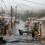
Maria, which left at least nine people dead in its wake across the Caribbean, blew ashore in the morning in the southeast coastal town of Yabucoa as a Category 4 hurricane with winds of 155 mph.
Maria slowly crossed the island, knocking down communication towers, snapping trees and unloading heavy rains. Widespread flooding was reported across the island, with dozens of cars half-submerged in some neighborhoods and many streets turned into rivers.
12:37 p.m.: Puerto Rico asks Trump for disaster declaration
Puerto Rico Gov. Ricardo Rossello has asked President Trump to declare the island a disaster zone, a step that would open the way to federal aid.
On Twitter, Rossello urged people to have faith: “We are stronger than any hurricane. Together, we will rebuild.”
Maria is one of the strongest hurricanes ever to hit Puerto Rico and could deepen the U.S. territory’s financial crisis.
12:21 p.m.: Roof, water tank take flight as Maria strikes
Some of the damage being reported in Puerto Rico include:
El Nuevo Dia newspaper reported that an emergency medical station in the north coastal town of Arecibo lost its roof.
People calling into local radio stations said that doors flew off hinges and a water tank flew away in the island’s southern region.
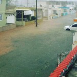
Widespread flooding was reported in the capital of San Juan.
About 90 percent of customers were without power.
A flooded road is seen after Hurricane Maria hit Puerto Rico Sept. 20, 2017, in this still image taken from social media.
11:44 a.m.: Parts of Puerto Rican capital lose communication
Parts of the Puerto Rican capital of San Juan have lost communication as Hurricane Maria moves over the U.S. island, law enforcement officials told CBS News.
CBS News correspondent David Begnaud reported on CBSN that winds from the Category 4 hurricane broke off the tops of palm trees and shattered windows.
The storm also caused trees to lean on power lines. The island’s power grid was heavily damaged by Hurricane Irma, which caused widespread devastation in the Caribbean.
11:01 a.m.: Maria a major hurricane over Puerto Rico
Hurricane Maria remained a Category 4 storm late Wednesday morning as it moved over Puerto Rico, the National Hurricane Center said.
As of 11 a.m., Maria had maximum sustained winds near 140 mph and its eye was located about 15 miles east-southeast of Arecibo and about 25 miles west of San Juan, the capital.
The hurricane was moving northwest at around 12 mph.
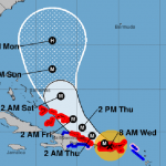
A map shows the probable path for Hurricane Maria as of 11 a.m. ET on Sept. 20, 2017. The M stands for “major hurricane.” The red areas represent hurricane warnings. The blue areas represent tropical storm warnings.
10:50 a.m.: Maria’s gusts turn streets into wind tunnels
Streets in the Puerto Rican capital of San Juan are like wind tunnels as Hurricane Maria barrels across the U.S. island, CBS News correspondent David Begnaud reports.
While reporting on CBSN, Begnaud said the storm was ripping off pieces of buildings and sending them through the air like projectiles.
The CBS News crew in San Juan recorded gusts of up to 120 mph with a wind speed gauge.
At the Marriott hotel, guests were ordered to the lobby for their safety and then into an emergency stairwell after pieces of the ceiling fell down.
10:15 a.m.: Trump on hurricanes: “It’s just one after another”
President Trump said “it’s just one after another” this hurricane season.
While meeting with Jordan’s King Abdullah in New York Wednesday morning, Mr. Trump spoke about Hurricane Maria as it was moving across Puerto Rico.
“We have a big one going right now,” Mr. Trump said. “I’ve never seen winds like this, and Puerto Rico, you take a look at what’s happening there, and it’s just one after another, but I think we are doing a good job.”
The king expressed his country’s condolences to the president for the victims of Hurricane Harvey, which hit Louisiana and Texas, and Hurricane Irma, which struck Florida and the Caribbean. He also praised the U.S. response to the devastating storms.
“For us sitting on the outside looking at how the Americans came together in a difficult time, it’s really an example to everybody else, and we’re very, very grateful for that,” the king said.
The king and Mr. Trump are in New York for the annual U.N. General Assembly.
9:23 a.m.: Maria moving across Puerto Rico
The eye of Hurricane Maria was expected to move across Puerto Rico throughout Wednesday morning, the U.S. National Hurricane Center said.
The center said the Category 4 storm’s eye would leave the island via its northern coast Wednesday afternoon. It was then expected to pass north of the northeast coast of the Dominican Republic Wednesday night or early Thursday.
As of 8 a.m. Wednesday, Maria had maximum sustained winds near 150 mph and was moving northwest near 10 mph. Its eye was about 15 miles south-southwest of Puerto Rico’s capital of San Juan.
8:49 a.m.: Maria’s death toll rises in Caribbean
An adviser to Dominican Prime Minister Roosevelt Skerrit says there have been seven confirmed deaths in the Caribbean country from Hurricane Maria.
Hartley Henry didn’t give details about how the deaths occurred. They raise the overall death toll to nine from the storm, including two on the French island of Guadeloupe.
Henry says the country is “in a daze” with no electricity or power and little to no communications.
He said in a statement Wednesday that there has been a “tremendous loss of housing and public buildings” in the mountainous island but the full extent of the damage isn’t known. The storm struck the country Monday and Tuesday and is now over Puerto Rico.
5:15 a.m.: New hurricane warnings posted
The government of the Bahamas has issued a hurricane warning for the Turks and Caicos Islands and the Southeastern Bahamas.
4:45 a.m.: Death toll ticks up
The prefect of the French island of Guadeloupe has raised the death toll stemming from Hurricane Maria from one to two people. Eric Maire said Tuesday night that in addition to one person who “did not comply with the confinement instructions” and was killed by a falling tree, another person died after falling “in the sea.”
The Guadeloupe prefecture has also said two people are reported missing after a shipwreck near the French island of Desirade.
France’s interior minister Gerard Collomb said there were three people wounded in Martinique, one seriously.
The extent of the damage from Tuesday’s hurricane is yet to be assessed on those French territories.
2:15 a.m.: Maria aiming at Puerto Rico
Hurricane Maria barreled toward Puerto Rico early Wednesday, and the National Hurricane Center warned the Category 5 storm could still be that strong when it unleashed its full fury there.
1:17 a.m.: Maria’s outer eyewall lashes St. Croix
The National Hurricane Center said Maria’s outer eyewall — the powerful ring that surrounds the core of the hurricane — was lashing St. Croix, one of the U.S. Virgin Islands, early Wednesday morning.
A sustained wind of 90 mph with a wind gust of 127 mph was reported in the western region of St. Croix, the National Hurricane Center said.
Tuesday, Sept. 19
10:50 p.m.: President Trump tweets about Puerto Rico
President Trump tweeted “our hearts are with” Puerto Rico, and wrote the island is about to be hit by a “new monster” hurricane.
In the past few weeks, Mr. Trump has visited several U.S. states hard-hit by hurricanes. Mr. Trump traveled to Texas and Louisiana twice in the wake of Hurricane Harvey. Then last week, he traveled to Fort Meyers and Naples, Florida, two of the places hardest hit by Hurricane Irma.
“I just want to tell you, we are there for you 100 percent. I’ll be back here numerous times. I mean, this is a state that I know very well, as you understand. And these are special, special people, and we love ’em,” Mr. Trump told reporters during his visit to Florida.
Irma did not directly hit Puerto Rico, but still battered the island with rain and wind and left 70 percent of the island without power.
IMAGES:
Hurricane Maria
A map shows the probable path for Hurricane Maria as of 8 a.m. ET on Sept. 20, 2017. The M stands for “major hurricane.” The red areas represent hurricane warnings. The blue areas represent tropical storm warnings. NATIONAL HURRICANE CENTER
A map shows the probable path for Hurricane Maria as of 11 a.m. ET on Sept. 20, 2017. The M stands for “major hurricane.” The red areas represent hurricane warnings. The blue areas represent tropical storm warnings. NATIONAL HURRICANE CENTER
A flooded road is seen after Hurricane Maria hit Puerto Rico Sept. 20, 2017, in this still image taken from social media. INSTAGRAM/HIGHASYOURDREAMS VIA REUTERS
For more on this story go to: https://www.cbsnews.com/news/hurricane-maria-path-track-puerto-rico-update-09-20-2017/


