Hurricane Florence is forecast to be as big as the whole state of North Carolina when it hits the US
 Hurricane Florence is surging toward the US East Coast with sustained wind speeds of 130 mph.
It is forecast to hit North Carolina later this week, by which time the storm could be as large as the state.
It is expected to strengthen to a Category 5 storm by Thursday.
The National Hurricane Center said it could bring devastating storms, rain, and floods.
1 million people have been ordered to evacuate.
Hurricane Florence is forecast to hit the US East Coast later this week, at which time the storm is expected to be about the size of North Carolina.


The hurricane was carrying sustained winds of 130 mph as of 11 a.m. ET on Tuesday, according to the National Hurricane Center.
“As it approaches North Carolina, Hurricane Florence will grow to the size of North Carolina,” the meteorologist Eric Holthaus tweeted.
Earlier Tuesday, the storm was forecast to strengthen into a Category 5 storm, the most intense category label on the Saffir-Simpson Hurricane Wind Scale, within 36 hours.
The graphs were produced by Tropical Tidbits, which used data from meteorological services in countries including the US, Canada, Germany, and Japan.
The storm, now considered a Category 4, was carrying sustained wind speeds of 140 mph earlier in the day. The NHC said the storm was likely to strengthen again soon.
As of Tuesday morning, it was moving toward the US coast at 16 mph from the northwestern Atlantic Ocean near Bermuda, southeast of the Carolinas.
The NHC reported at 5 a.m. Tuesday that Florence could approach “Category 5 strength within the next 24 to 36 hours.”
Category 5 is the highest level on the Saffir-Simpson scale, which is used to assess the intensity of hurricanes in the Atlantic and the northern Pacific. It is also used to estimate property damage and coastal flooding.
Storms with sustained wind speeds of 157 mph or higher are labeled Category 5.
The storm could remain powerful as it passes over the US mainland, and it could penetrate as far as Pittsburgh, in western Pennsylvania.
The NHC on Tuesday warned of a “life-threatening storm surge” and “damaging hurricane-force winds” along the coastlines of North Carolina, South Carolina, and Virginia.
It also said “life-threatening freshwater flooding” and “a prolonged and exceptionally heavy rainfall event” could take place in those states and move inland for hundreds of miles.
The main threat to life from Hurricane Florence is storm surge, which has historically accounted for half of all hurricane deaths, Holthaus said.
A buoy from the National Oceanic and Atmospheric Administration, located about 80 nautical miles north of the eye of the storm, reported tropical-storm-force winds over several hours on early Tuesday morning and sea levels as high as 23 feet.
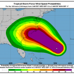
The map below shows the probable path of the storm center over the next few days. “Hazardous conditions,” such as heavy wind, rainfall, and floods, can take place outside the projected zone, the NHC said.
Hurricane Florence is poised to make landfall early Friday somewhere around North Carolina and South Carolina. It is expected to slow down as it approaches the coast and continue moving inland.
It could inflict the hardest hurricane on the Carolinas in recent history. North Carolina most recently experienced a Category 4 storm in 1954.
The two Carolinas as well as Virginia have declared a state of emergency as they make preparations.
About 1 million people have been ordered to evacuate their homes. Millions of others have been stockpiling supplies such as gas cans, generators, plywood, and sand bags, according to the Associated Press.
President Donald Trump on Monday night approved emergency declarations in the Carolinas and authorized the Department of Homeland Security and the Federal Emergency Management Agency to assist in response efforts.
Donald J. Trump
✔
@realDonaldTrump
My people just informed me that this is one of the worst storms to hit the East Coast in many years. Also, looking like a direct hit on North Carolina, South Carolina and Virginia. Please be prepared, be careful and be SAFE!
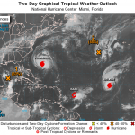
Two other hurricanes, Isaac and Helene, are also spinning in the Atlantic Ocean. The map below, published early Tuesday morning, shows their approximate locations.
IMAGES:
hurricane florence stockpiling
Larry Pierson, from the Isle of Palms, South Carolina, buying bottled water on Monday in preparation for Hurricane Florence. Mic Smith/AP
hurricane florence projected schedule
NOAA
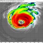
Hurricane Florence satellite image
Hurricane Florence gaining strength in the Atlantic Ocean, as seen in a photo taken by the NASA astronaut Ricky Arnold on Monday. NASA via Getty Images
saffir simpson hurricane scale
Samantha Lee/Business Insider
hurricane florence projected path sept 11 16
NOAA
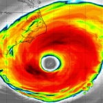
The GIF below visualizes the hurricane swirling over the Atlantic this week. The color scale on the right side shows the brightness temperature, which is a measurement of intensity.
hurricane florence eye sept 11
For more on this story go to: https://www.businessinsider.com/hurricane-florence-brings-winds-risk-of-floods-to-us-east-coast-2018-9?utm_source=feedburner&%3Butm_medium=referral&utm_medium=feed&utm_campaign=Feed%3A+businessinsider+%28Business+Insider%29
Related:
Hurricane, Storm Surge Warnings Up for Carolinas; Florence May Stall Near Coast
By Bob Henson · From Weather Underground
Sentinel3 image of Hurricane Florence from Tuesday afternoon, September 11, 2018. Image Credit: Copernicus EU.
Hurricane and storm surge warnings were issued Tuesday afternoon ahead of Hurricane Florence, which is increasingly likely to deliver one of the most destructive and prolonged disasters ever seen in the Carolinas. As of 8 pm EDT Tuesday, a hurricane warning was in effect from South Santee River, South Carolina, to Duck, North Carolina, including the Albemarle and Pamlico Sounds. A storm surge warning covered the same area, as well as the low-lying Neuse and Pamlico Rivers just inland. Hurricane and storm surge watches extended southward to Edisto Beach, SC, and north to the Virginia-NC border. A tropical storm watch covers the southeast Virginia coast up to Cape Charles Light and Chesapeake Bay south of New Point Comfort.
Florence was again on the upswing in intensity late Tuesday after its strength was briefly dented Monday night by an eyewall replacement cycle, as explained by Dr. Jeff Masters in our previous post. A new, larger eye (about 30 miles across) is now in place, and that will allow the hurricane’s wind field to expand as well. Satellite images on Tuesday night showed that Florence was still adjusting to its new eye, and had an asymmetric shape with a relatively thin area of heavy thunderstorms on the southwest side. Florence’s top sustained winds were raised to 140 mph by the National Hurricane Center at 5 pm Tuesday. Sustained hurricane-force winds now extend up to 60 miles out from Florence’s center, and tropical-storm-force winds extend out 175 miles. These numbers may grow even larger as Florence matures and expands. At its current size, Florence rates as an average-sized hurricane.
No hurricane-hunter flights gathered data from Florence on Tuesday afternoon, but an Air Force plane penetrated the eye at 9 pm EDT Tuesday, and found a central pressure near 944 mb, just 1 mb below what NHC was estimating in their 8 pm EDT advisory. The mission will last into the early morning hours Wednesday.
Conditions are close to ideal for Florence to strengthen further into Wednesday. Wind shear will be less than 10 knots, and Florence will be passing over a pocket of deep warm water with high oceanic heat content on Tuesday night. Two high-altitude outflow channels—one on each side of the storm’s center—will keep Florence well-ventilated. Dry air has been lurking around Florence, but the newly rebuilt core should keep that dry air at bay. The NHC forecast brings Florence’s sustained winds to 155 mph by Wednesday, just shy of Category 5 strength. With the conditions so supportive, it’s entirely possible that Florence might cross this threshold and become a Category 5 for at least a few hours on Wednesday. If so, it will enter the history books as the northernmost Category 5 on record.
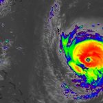
Infrared satellite image of the Southeast U.S. coast (left) with Hurricane Florence (right) at 8:57 pm EDT Tuesday, September 11, 2018
Figure 1. Infrared satellite image of the Southeast U.S. coast (left) with Hurricane Florence (right) at 8:57 pm EDT Tuesday, September 11, 2018. Image credit: NASA/MSFC Earth Science Branch.
As Florence nears the coast on Thursday night, wind shear may increase to a moderate 10 – 20 knots, and the shallower waters near the coast will provide less oceanic fuel. Florence will most likely be a Category 3 near landfall—assuming it crosses the coast, that is. The steering currents driving Florence toward the East Coast will collapse on Friday, and models now agree the storm is likely to stall somewhere within 100 miles on either side of the coast, perhaps for one or two days.
The 12Z Tuesday run of the European model introduced a new and very distressing possibility: Florence stalling just offshore of North Carolina near Wilmington for roughly a day, then moving southwestward along and just off the South Carolina coast on Saturday, and finally making landfall close to Savannah, Georgia, on Sunday—all while still a hurricane. This outlandish-seeming prospect gained support from the 18Z run of the GFS model. It painted a very similar picture, with a landfall a bit farther north, near Charleston, on Sunday. The 18Z track from the experimental GFS FV3 model is very similar to the GFS track.
The 12Z Tuesday, September 11, 2018, track forecast by the operational and ensemble members of the European model
Figure 2. The 12Z Tuesday, September 11, 2018, track forecast by the operational European model for Florence (red line, adjusted by CFAN using a proprietary technique that accounts for storm movement since the time of the model run), along with the track of the average of the 50 members of the European model ensemble (heavy black line), and the track forecasts from the “high probability cluster” (grey lines)—the four European model ensemble members that have performed best with Florence thus far. The forecasts agree strongly that Florence will move very near the coast of southern North Carolina, and all but one of the ensemble members then move the storm southwest along or near the coast into South Carolina, then well inland by Sunday/Monday. At right are the projected intensities in knots from each ensemble member; multiply by 1.15 for miles per hour. Image credit: CFAN.
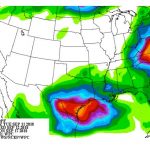
A high-confidence forecast: Biblical rains
Because the steering currents will be so weak from Friday onward, forecast models will struggle to capture their details, which may lead to big track changes from run to run for the period after Friday. Despite this uncertainty, we’re very confident that Florence’s slow movement from Friday into the weekend will lead to titanic rainfall amounts in at least some places. The 5-day rainfall outlook from the NOAA/NWS Weather Prediction Center (see below) includes a patch of 20”+ totals near the southernmost coast of North Carolina, including the Wilmington area. A much larger area of 10” – 20” includes the eastern third of the state. Local amounts could reach 35”, according to NHC; this would exceed the heaviest rains any tropical cyclone has produced in the contiguous U.S. outside of Texas, Mississippi, and Florida.
How far inland and southward the very heaviest rains extend will depend on Florence’s track from Friday onward, but widespread flash flooding will likely be a risk at least through the weekend, and river flooding well into next week. If Florence moves inland and up the crest of the Appalachians early next week, as is now suggested by the GFS and European models, the flood threat would expand even further.
NOAA’s 5-day precipitation outlook for the period starting at 8 pm EDT Tuesday, September 11, 2018
Figure 3. NOAA’s 5-day precipitation outlook for the period starting at 8 pm EDT Tuesday, September 11, 2018. If Florence ends up moving southward along the South Carolina coast, some of the heavier amounts shown here would shift in that direction. See below for discussion of the heavy rains along the Texas coast, which will be produced by a separate disturbance. Image credit: NOAA/NWS Weather Prediction Center.
The bottom line: There’s very high confidence that Florence will reach the southern coast of North Carolina on Thursday night as a very dangerous major hurricane. It now looks increasingly possible that Florence will stay near the coast (either inland or just offshore) for a day or longer, perhaps moving southwest along the coast. In this case, the coastline north of the center could experience storm surge during at least two 12-hour tidal cycles, rather than just one, and at least some surge could spread southwest with Florence. Florence’s track beyond Friday is still subject to major change as the weak steering currents evolve.
Preparing for a siege
Mandatory and voluntary evacuation orders were in place late Tuesday for large parts of the East Coast from South Carolina to Virginia. See weather.com’s state-by-state evacuation roundup for frequent updates. Surge flooding may push well inland through rivers across the coastal plain of North Carolina. As Florence’s rains pile up, inland flooding will become an increasingly serious threat. Referring to the expected rainfall totals, NHC warned: “This rainfall would produce catastrophic flash flooding and significant river flooding.”
If the latest GFS and European tracks came to pass, and Florence lingers just offshore for a day or more, surge damage and beach erosion could be truly devastating for parts of North Carolina. Even people living well inland, within 50 – 100 miles of the coast, could experience huge amounts of rainfall and a long period of tropical-storm-force winds capable of bringing down trees and power lines. Residents in these areas would be well advised to prepare for multiple days of power outages and limited mobility, even if they’re not in mandatory evacuation zones.
Above all, residents of the coastal and near-coastal Carolinas should keep in mind that Florence is a historic storm. Its strength, size, and potentially unorthodox track all point to outcomes that may lie outside historical experience.
Jeff Masters contributed to this post.
For more on this story go to: https://www.wunderground.com/cat6/Hurricane-Storm-Surge-Warnings-Carolinas-Florence-May-Stall-Near-Coast


