Hurricane Dorian: Scale of Bahamas devastation emerges
From BBC

Rescuers have begun to reach areas of the northern Bahamas devastated by Hurricane Dorian, with aerial images showing a trail of destruction.
PM Hubert Minnis said some areas had been “decimated” and expected the current death toll of seven would rise.
The hurricane winds that hit the Abaco Islands equalled the highest ever recorded at landfall, and Grand Bahama also suffered severe damage and floods.
Dorian has moved off north but still threatens the eastern US seaboard.
Forecasters have warned it could make landfall on the coast of South or North Carolina on Thursday.
- From the air – the destruction of the Abaco Islands
- Hurricane Dorian: Who’s at risk?
- Are you in the affected region? Email [email protected].

Although the hurricane has weakened to a category two storm with maximum sustained winds of 105mph (165km/h), it has grown larger in area.
What is the damage to the Abacos and Grand Bahama?
Mr Minnis confirmed the death toll had risen from five to seven, but added: “We can expect more deaths to be recorded. This is just preliminary information.”
He said the Bahamas was facing “one of the greatest national crises in our country’s history”.
Lia Head-Rigby, who runs a relief group and overflew the Abacos, said her representatives had told her there were “a lot more dead”.
“It’s total devastation. It’s decimated. Apocalyptic,” she told the Associated Press (AP) news agency.
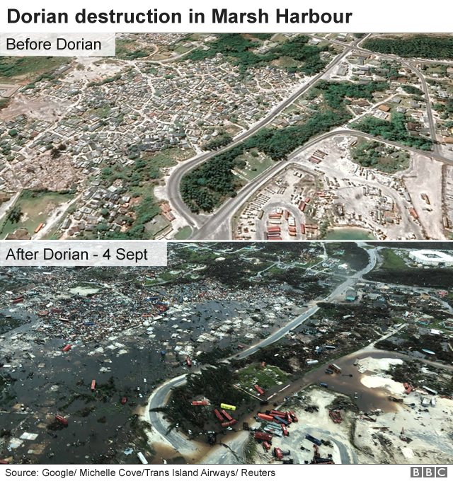
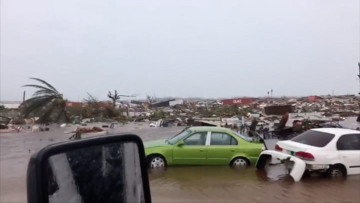
Aerial images over the Abacos, including the port town of Marsh Harbour, showed mile upon mile of destruction, with roofs torn off, scattered debris, overturned cars, shipping containers and boats, and high water levels.
Opposition leader Philip Brave Davis described the scenes from a flight over the islands as a “horrible sight”.
Parts of the Bahamas received up to 35in (89cm) of rain.
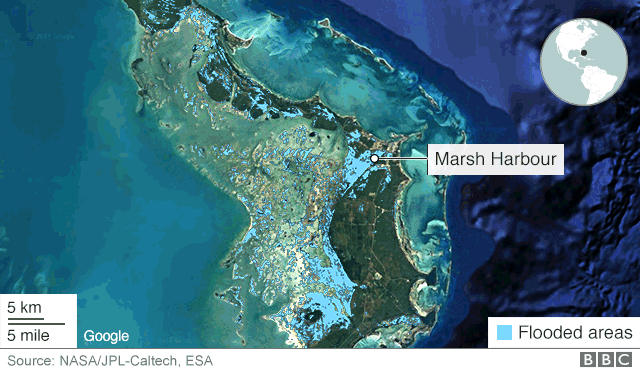
INTERACTIVESee extent of flooding in Abaco Islands caused by Hurricane Dorian
After Dorian
Before Dorian
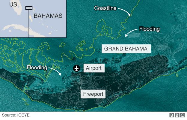
The situation on Grand Bahama is less clear, as Dorian only moved on late on Tuesday after nearly two days of pummelling, cutting many communication lines.
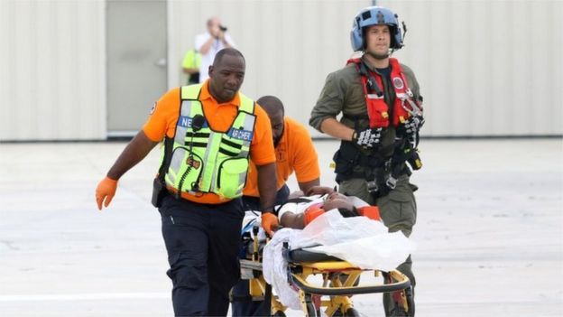
Most rescue work was being done on an ad hoc basis by locals using boats and jet skis, but it was being hampered by flooded roads, fallen trees and submerged debris.
Rescue teams were “beginning to get on the ground”, National Security Minister Marvin Dames said on Wednesday, according to AP.
One survivor in Freeport on Grand Bahama, crab fisherman Howard Armstrong, told CNN floodwaters had reached the roof of his house and his wife “got hypothermia and she was standing on top of the kitchen cabinets until they disintegrated… I kept with her and she just drowned on me”.
Mr Minnis said: “Our priority at this time is search, rescue and recovery. It will take all of us as a caring community – government, church, businesses and individuals – to help restore the lives of our people.”
People have taken to social media to post lists of those they have lost contact with during the storm.
The International Red Cross fears 45% of homes on Grand Bahama and the Abacos – some 13,000 properties – have been severely damaged or destroyed.
Some 60,000 people will need food aid and clean water, UN officials say.
A map from the Finnish satellite company ICEYE showed the extent of the flooding on Grand Bahama:
Where is the storm now?
At 15:00 GMT, the National Hurricane Center said Dorian was located about about 90 miles (140km) east of Daytona Beach in Florida and about 205 miles south of Charleston, South Carolina.
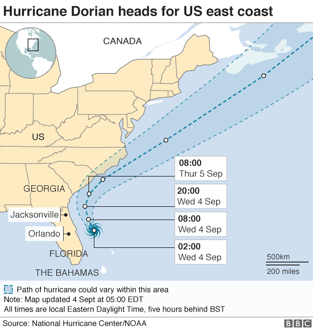
It is moving north-northwest at 9mph (15km/h) ad is expected to turn north on Wednesday evening, followed by a turn to the north-east.
The NHC said Dorian was expected to weaken over the next few days but would remain a powerful hurricane.
The storm would move parallel to the Florida and Georgia coasts through Wednesday night, then “near or over” the coasts of the Carolinas through Thursday and Friday, it said.
President Donald Trump tweeted that the US “may be getting a little bit lucky with respect to Hurricane Dorian, but please don’t let down your guard”.
Is climate change making hurricanes worse?
Scientists cannot say whether climate change is increasing the number of hurricanes, but the ones that do happen are likely to be more powerful and more destructive because of our warming climate, says BBC Weather’s Tomasz Schafernaker.
Here’s why:
- An increase in sea surface temperatures strengthens the wind speeds within storms and also raises the amount of precipitation a hurricane will dump
- Sea levels are expected to increase by one to four feet over the next century, bringing the potential of far worse damage from sea surges and coastal flooding during storms
For more on this story and video go to: https://www.bbc.com/news/world-latin-america-49574900


