2017 Atlantic Hurricane Season Forecast calls for less activity than 2016
 By Jon Erdman From Weather Underground
The 2017 Atlantic hurricane season forecast released Thursday from Colorado State University calls for the number of named storms and hurricanes to be slightly below historical averages.
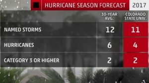
A total of 11 named storms, four hurricanes and two major hurricanes are expected this season, according to the forecast prepared by the CSU Tropical Meteorology Project, headed by Dr. Phil Klotzbach.
This is slightly below the 30-year average of 12 named storms, six hurricanes and two major hurricanes. A major hurricane is one that is Category 3 or stronger on the Saffir-Simpson Hurricane Wind Scale.


Though the official Atlantic hurricane season runs from June through November, occasionally we can see storms form outside those months, as happened last season with January’s Hurricane Alex and late May’s Tropical Storm Bonnie.
The CSU outlook is based on a combination of 29 years of statistical predictors, combined with analog seasons exhibiting similar features of sea-level pressure and sea-surface temperatures in the Atlantic and eastern Pacific Oceans.
Here are three questions what this outlook means.
Q: What Does This Mean For the U.S.?
There is no strong correlation between the number of storms or hurricanes and U.S. landfalls in any given season. One or more of the 12 named storms forecast to develop this season could hit the U.S., or none at all. Therefore, residents of the coastal United States should prepare each year no matter the forecast.
A couple of classic examples of why you need to be prepared each year occurred in 1992 and 1983.
The 1992 season produced only six named storms and one subtropical storm. However, one of those named storms was Hurricane Andrew, which devastated South Florida as a Category 5 hurricane.
In 1983 there were only four named storms, but one of them was Alicia. The Category 3 hurricane hit the Houston-Galveston area and caused almost as many direct fatalities there as Andrew did in South Florida.
In contrast, the 2010 season was active. There were 19 named storms and 12 hurricanes that formed in the Atlantic Basin.
Despite the large number of storms that year, not a single hurricane and only one tropical storm made landfall in the United States.
In other words, a season can deliver many storms, but have little impact, or deliver few storms and have one or more hitting the U.S. coast with major impact.
The U.S. averages one to two hurricane landfalls each season, according to NOAA’s Hurricane Research Division statistics.
In 2016, five named storms impacted the Southeast U.S. coast, most notably the powerful scraping of the coast from Hurricane Matthew, and its subsequent inland rainfall flooding.
Prior to that, the number of U.S. landfalls had been well below average over the previous 10 years.
The 10-year running total of U.S. hurricane landfalls from 2006 through 2015 was seven, according to Alex Lamers, a meteorologist with The National Weather Service. This was a record low for any 10-year period dating to 1850, considerably lower than the average of 17 per 10-year period dating to 1850, Lamers added.
Of course, the record-breaking 2005 hurricane season was outside that current 10-year running total. It was also the last season we saw a Category 3 or stronger hurricane (Wilma) hit the U.S., the longest such streak dating to the mid-19th century.
Bottom line: It’s impossible to know for certain if a U.S. hurricane strike, or multiple strikes, will occur this season. Keep in mind, however, that even a weak tropical storm hitting the U.S. can cause major impacts, particularly if it moves slowly, resulting in flooding rainfall.
Q: Will El Niño play a role?
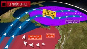
The odds are increasing for a return to a weak or moderate El Niño by the heart of the hurricane season.
This periodic warming of the central and eastern equatorial waters of the Pacific Ocean tends to produce areas of stronger wind shear (the change in wind speed with height) and sinking air in parts of the Atlantic Basin that is hostile to either the development or maintenance of tropical cyclones.
In the outlook, Klotzbach said the potential development of El Niño is different than anything seen since 1980, complicating the forecast.
“Current SST (sea-surface temperature) anomalies in the Nino 1+2 region are some of the warmest ever observed,” wrote Klotzbach.
“These warm SST anomalies off the west coast of South America may be a harbinger of a developing El Niño event.” Klotzbach also cautions there is considerable uncertainty regarding the eventual strength of El Niño, assuming it even occurs.
The most recent El Niño strengthened quickly during the 2015 season, which featured 11 named storms, 4 hurricanes and 2 major hurricanes. Hurricane Joaquin’s prolonged pummeling of the Bahamas was the most notable hurricane that season.
Strong wind shear near the Caribbean Sea and other parts of the Atlantic Basin contributed to the eventual demise of five named storms during the heart of the 2015 season.
Klotzbach found that June through October 2015 Caribbean wind shear was the highest on record dating to 1979. Klotzbach also said the magnitude of dry air over the Caribbean Sea in the peak season month of August and September also set a record.
Q: Any Other Factors in Play?
Dry air and wind shear can be detrimental to tropical storm or hurricane development no matter whether El Niño is present or not.
The 2013 and 2014 seasons featured prohibitive dry air and/or wind shear during a significant part of the season, but El Niño was nowhere to be found.
Klotzbach also said the northern Atlantic Ocean has water temperatures that are colder than average, and tropical Atlantic sea-surface temperatures have also cooled, both of which can cause atmospheric conditions to be unfavorable for the development and strengthening of Atlantic hurricanes.
This was the first April outlook issued since the passing of Dr. William Gray, noted hurricane researcher and emeritus professor of atmospheric science at Colorado State University.
Gray, who died in April, was the creator of the yearly Atlantic hurricane season outlooks, which have been published every year since 1984. He developed the parameters for these outlooks in the late 1960s, which was considered ground-breaking research at that time.
IMAGES:
Numbers of Atlantic Basin named storms, those that attain at least tropical storm strength, hurricanes, and hurricanes of Category 3 intensity forecast by Colorado State University compared to the 30-year average. (Forecast: Tropical Meteorology Project/Colorado State University)
The named storms that affected the U.S. in 2016 were clustered in the Southeast.
The effects of El Niño in the eastern Pacific, Caribbean and western Atlantic Ocean.
Named storm tracks in the 2016 Atlantic hurricane season.
2017 Atlantic hurricane season names.
For more on this story and video go to: https://www.wunderground.com/news/2017-hurricane-season-forecast-atlantic-colorado-state


